File:Hurricane Lane (MODIS 2018-08-25).jpg

Original file (5,797 × 4,896 pixels, file size: 2.55 MB, MIME type: image/jpeg)
Captions
Captions
Summary[edit]
.jpg&action=edit§ion=1)
| Description |
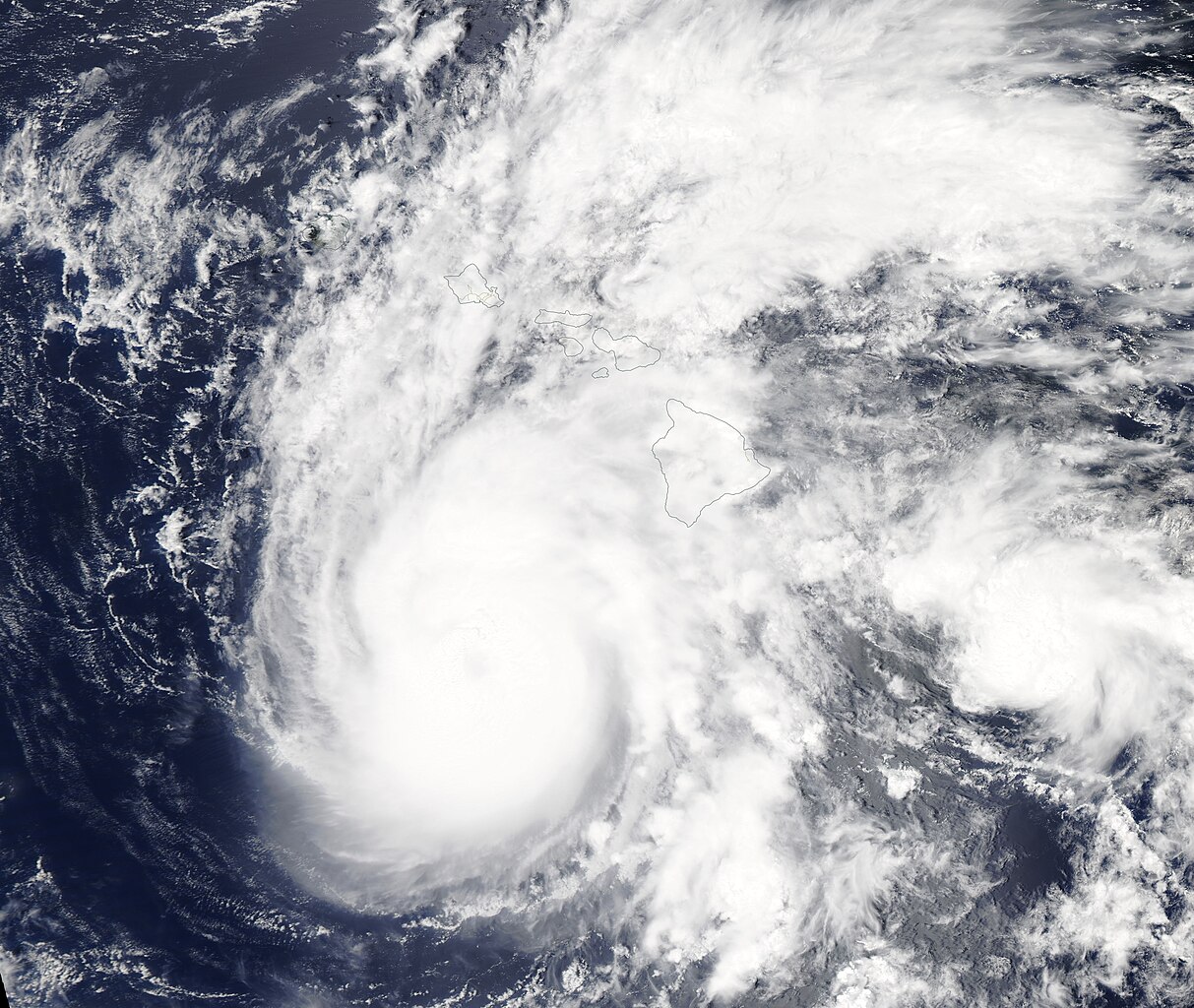
English: At 0600 UTC on August 21, 2018 (2:00 am EDT on August 22), Hurricane Lane strengthened to Category 5 strength as crossed the Pacific Ocean heading towards Hawaii. With maximum sustained winds of 160 mph (257.5 km/h) Lane became the strongest storm in the Central Pacific Ocean since Hurricane Patricia in 2015.
Lane maintained strength for about 24 hours before encountering increasingly adverse conditions south of the Hawaiian Islands. By 5:00 p.m. EDT on August 24, Hurricane Lane’s maximum sustained winds had dropped to 105 mph (169 km/h), making it a Category 2 storm on the Saffir-Simpson Hurricane Wind Scale. Only six hours later, at 11:00 p.m. EDT, maximum sustained winds had dropped to 70 mph (112.6 km/h), bringing Lane from hurricane to tropical storm status. It was located about 150 miles south of Honolulu. Even though Hurricane Lane was diminishing in strength as it passed well offshore of the Hawaiian Islands, the convective bands of the very large storm covered the Big Island, bringing catastrophic rain and flooding. On August 24, the National Weather Service Honolulu reported preliminary rain totals of 31.21 inches (791 mm) at Hakalau Station and 23.67 in (601.2 mm) at Waikea Experimental Station, both on the Big Island (Hawaii). On August 23, 2018, the Moderate Resolution Imaging Spectroradiometer (MODIS) on board NASA’s Aqua satellite acquired a true-color image of Hurricane Lane when it was still a major hurricane (Category 4). The eye of the storm is well south of the Hawaiian Islands but the rain bands reach far over the Big Island. |
||
| Date | Taken on 23 August 2018 | ||
| Source |
|
||
| Author | MODIS Land Rapid Response Team, NASA GSFC |
| This media is a product of the Aqua mission Credit and attribution belongs to the mission team, if not already specified in the "author" row |
Licensing[edit]
.jpg&action=edit§ion=2)
| This file is in the public domain in the United States because it was solely created by NASA. NASA copyright policy states that "NASA material is not protected by copyright unless noted". (See Template:PD-USGov, NASA copyright policy page or JPL Image Use Policy.) | ||
 |
Warnings:
|
File history
Click on a date/time to view the file as it appeared at that time.
| Date/Time | Thumbnail | Dimensions | User | Comment | |
|---|---|---|---|---|---|
| current | 01:33, 17 February 2024 | | 5,797 × 4,896 (2.55 MB) | OptimusPrimeBot (talk | contribs) | #Spacemedia - Upload of http://modis.gsfc.nasa.gov/gallery/images/image08252018_250m.jpg via Commons:Spacemedia |
You cannot overwrite this file.
File usage on Commons
There are no pages that use this file.
.jpg&oldid=852755216)