File:Hungarian autonomous province02.png
Jump to navigation
Jump to search
Size of this preview: 619 × 599 pixels. Other resolutions: 248 × 240 pixels | 496 × 480 pixels | 751 × 727 pixels.
Original file (751 × 727 pixels, file size: 60 KB, MIME type: image/png)
Captions
Captions
Add a one-line explanation of what this file represents

|
This map image could be re-created using vector graphics as an SVG file. This has several advantages; see Commons:Media for cleanup for more information. If an SVG form of this image is available, please upload it and afterwards replace this template with
{{vector version available|new image name}}.
It is recommended to name the SVG file “Hungarian autonomous province02.svg”—then the template Vector version available (or Vva) does not need the new image name parameter. |
Summary[edit]
| Description |
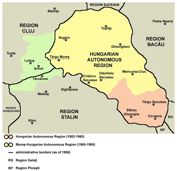
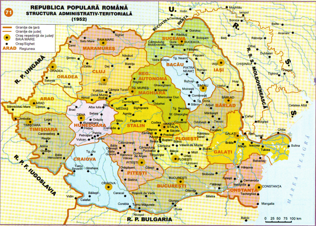
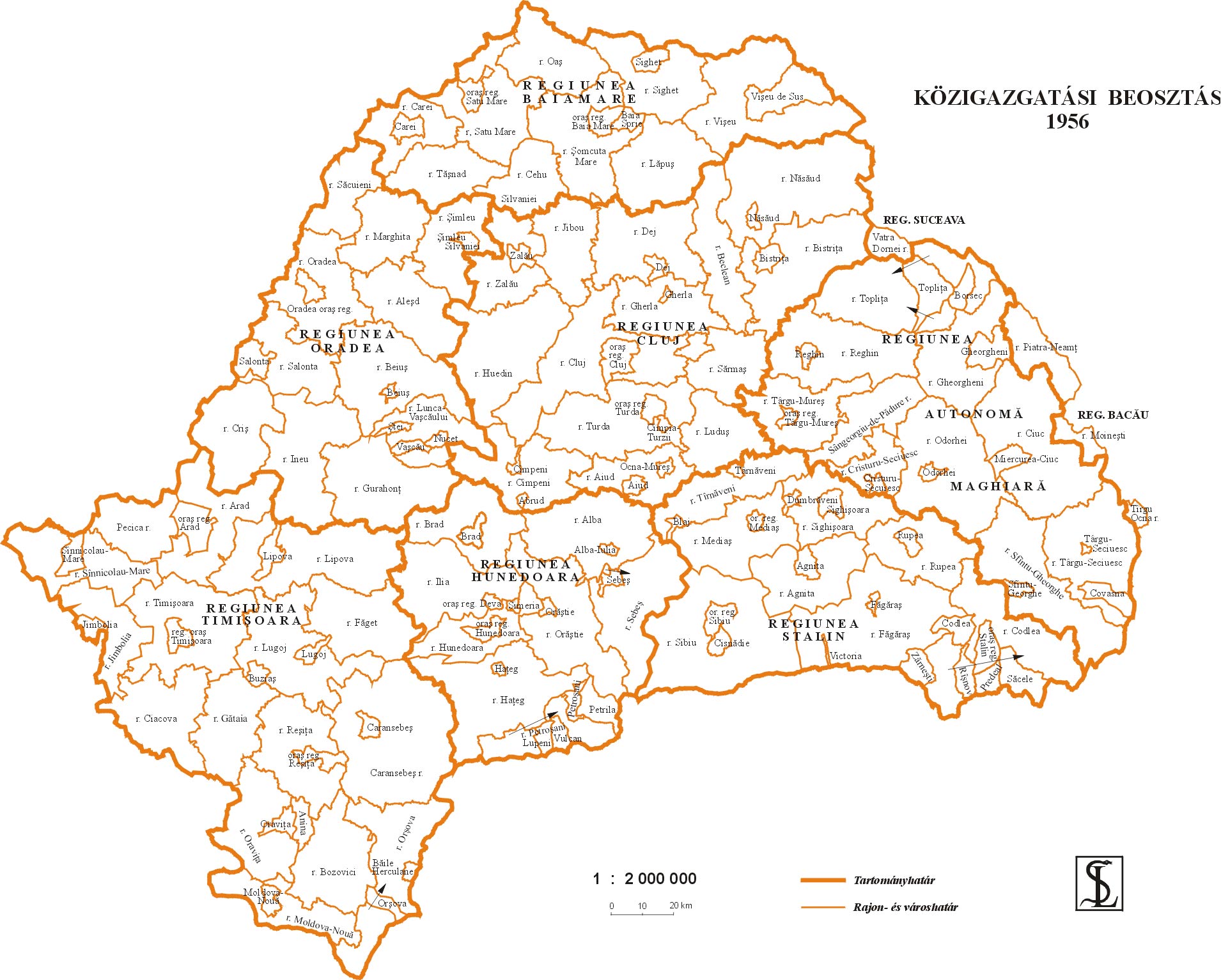
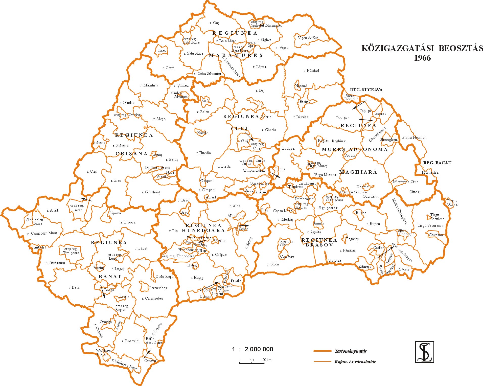
English: Map of the Hungarian Autonomous Region / Magyar Autonomous Region (1952-1960) and Mureş-Hungarian Autonomous Region / Mureş-Magyar Autonomous Region (1960-1968). |
| Date | |
| Source | Transferred from en.wikipedia |
| Author | PANONIAN (talk · contribs) |
Licensing[edit]
| I, the copyright holder of this work, release this work into the public domain. This applies worldwide. In some countries this may not be legally possible; if so: I grant anyone the right to use this work for any purpose, without any conditions, unless such conditions are required by law. |

|
This map has been uploaded by Electionworld from en.wikipedia.org to enable the |
References[edit]
Primary reference:
Secondary references:
- http://www.adevarul.ro/bbtcontent/clipping/ADVIMA20110612_0443/1.jpg
- http://www.hungarian-human-rights.eu/images/rpr_1952.jpg
- http://sebok1.adatbank.transindex.ro/kepek/erd1956.jpg
- http://sebok1.adatbank.transindex.ro/kepek/erd1966.jpg
- http://2.bp.blogspot.com/_yYcDY0o6YEA/SXaL1dSAXGI/AAAAAAAAAFk/21nu4zMSKJ8/s600/RO1960-1968.jpg
File history
Click on a date/time to view the file as it appeared at that time.
| Date/Time | Thumbnail | Dimensions | User | Comment | |
|---|---|---|---|---|---|
| current | 18:59, 26 March 2013 | | 751 × 727 (60 KB) | PANONIAN (talk | contribs) | Reverted to version as of 13:05, 24 October 2011 I do not agree with your changes, please upload your file under different name |
| 09:09, 26 March 2013 |  | 619 × 599 (103 KB) | Rgvis (talk | contribs) | Improved version with administrative borders changes shown during the existance of the Soviet-inspired administrative and territorial organisation in Communist Romania (1950-1968). | |
| 13:05, 24 October 2011 |  | 751 × 727 (60 KB) | PANONIAN (talk | contribs) | improved version | |
| 18:56, 28 December 2006 |  | 716 × 620 (11 KB) | Electionworld (talk | contribs) | {{ew|en|PANONIAN}} map of the Hungarian Autonomous Province (self made) {{PD-self}} Category:Maps of the history of Romania |
You cannot overwrite this file.
File usage on Commons
The following 5 pages use this file:
File usage on other wikis
The following other wikis use this file:
- Usage on ar.wikipedia.org
- Usage on be.wikipedia.org
- Usage on bg.wikipedia.org
- Usage on ca.wikipedia.org
- Usage on en.wikipedia.org
- Usage on es.wikipedia.org
- Usage on fr.wikipedia.org
- Usage on hu.wikipedia.org
- Usage on it.wikipedia.org
- Usage on mk.wikipedia.org
- Usage on nl.wikipedia.org
- Usage on pl.wikipedia.org
- Usage on pt.wikipedia.org
- Usage on ro.wikipedia.org
- Usage on ru.wikipedia.org
- Usage on sl.wikipedia.org
- Usage on sr.wikipedia.org
- Usage on uk.wikipedia.org
- Usage on www.wikidata.org