File:Hungarian-Romanian War.de.png
Jump to navigation
Jump to search

Size of this preview: 800 × 566 pixels. Other resolutions: 320 × 226 pixels | 640 × 453 pixels | 1,024 × 724 pixels | 1,280 × 905 pixels | 2,560 × 1,810 pixels | 15,154 × 10,715 pixels.
Original file (15,154 × 10,715 pixels, file size: 7.02 MB, MIME type: image/png)
Captions
Captions
Add a one-line explanation of what this file represents
Summary[edit]
| Warning | The original file is very high-resolution. It might not load properly or could cause your browser to freeze when opened at full size. |
|---|
| Description |
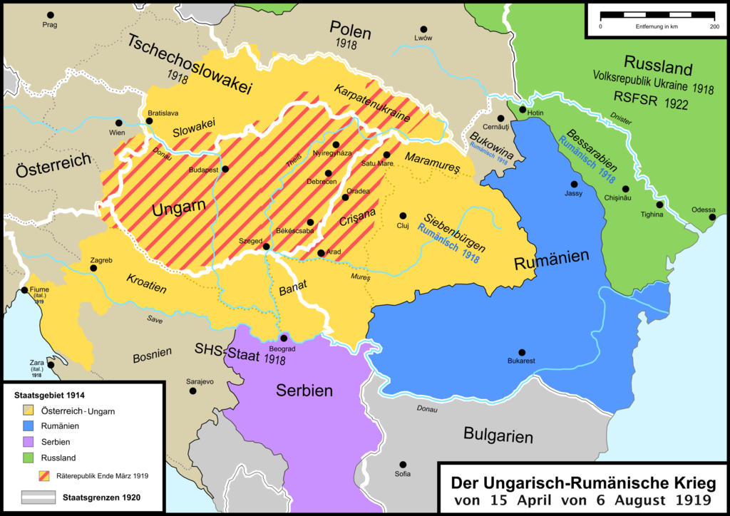
English: Map of the War between Hungary and Romania in 1919 in german. |
| Date | |
| Source | Own work; Territory of Hungarian Soviet Republic based on: Helga Weck (Hrsg.), Taschenlexikon Ungarn, Leipzig 1981, S. 203 |
| Author | Kryston |
Licensing[edit]
I, the copyright holder of this work, hereby publish it under the following licenses:
This file is licensed under the Creative Commons Attribution-Share Alike 3.0 Unported license.
- You are free:
- to share – to copy, distribute and transmit the work
- to remix – to adapt the work
- Under the following conditions:
- attribution – You must give appropriate credit, provide a link to the license, and indicate if changes were made. You may do so in any reasonable manner, but not in any way that suggests the licensor endorses you or your use.
- share alike – If you remix, transform, or build upon the material, you must distribute your contributions under the same or compatible license as the original.

|
Permission is granted to copy, distribute and/or modify this document under the terms of the GNU Free Documentation License, Version 1.2 or any later version published by the Free Software Foundation; with no Invariant Sections, no Front-Cover Texts, and no Back-Cover Texts. A copy of the license is included in the section entitled GNU Free Documentation License. |
You may select the license of your choice.
File history
Click on a date/time to view the file as it appeared at that time.
| Date/Time | Thumbnail | Dimensions | User | Comment | |
|---|---|---|---|---|---|
| current | 13:44, 18 March 2019 | | 15,154 × 10,715 (7.02 MB) | Julieta39 (talk | contribs) | Weitere Details. Räterrepublik : rot. Differenziert internationale Grenzen vs innen Trennungen und österreich-Ungarn vs anderen Staaten. |
| 19:08, 3 September 2016 |  | 15,154 × 10,715 (6.83 MB) | Julieta39 (talk | contribs) | Genauer - More precise | |
| 09:50, 13 July 2016 |  | 15,154 × 10,715 (6.24 MB) | Kryston (talk | contribs) | plus territory of Hungarian Soviet Republic minus campaigns | |
| 15:06, 14 August 2014 |  | 2,993 × 2,117 (974 KB) | Terek (talk | contribs) | an error corrected: Russland (RSFSR) -> Sowjetukraine | |
| 16:21, 17 August 2009 |  | 2,993 × 2,117 (926 KB) | Olahus (talk | contribs) | m | |
| 09:43, 29 June 2009 |  | 2,993 × 2,117 (998 KB) | Kryston (talk | contribs) | {{Information |Description={{en|1=Map of the War between Hungary and Romania in 1919 in german.}} |Source=Own work by uploader |Author=Kryston |Date=2009-06-29 |Permission= |other_versions= }} <!--{{ImageUpload|full}}--> [[Category:Hunga |
You cannot overwrite this file.
File usage on Commons
The following page uses this file:
File usage on other wikis
The following other wikis use this file:
- Usage on de.wikipedia.org
- Usage on nl.wikipedia.org
- Usage on pt.wikipedia.org
- Usage on ro.wikipedia.org
- Usage on sr.wikipedia.org
- Usage on uk.wikipedia.org