File:Hunga Tonga-Hunga Ha-'apai in Tonga, South Pacific Ocean (MODIS 2015-01-29).jpg

Original file (600 × 800 pixels, file size: 141 KB, MIME type: image/jpeg)
Captions
Captions
Summary
[edit].jpg&action=edit§ion=1)
| Description |
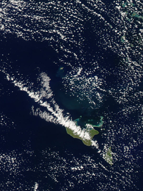
English: On January 28, 2015 Tonga�s Ministry of Information and Communications announced that the volcanic eruption between Hunga Tonga and Hunga Ha�apai, located in the South Pacific Ocean 65 km from Nuku�alofa had ceased � and confirmed an official visit to the newly formed island. The site expedition was sponsored by the New Zealand High Commission and conducted on January 24. At that time, there were no signs of any emissions of ash, gas or steam from the vent of the newly formed island, nor any smells of volcanic gases within 100 m of the island.
On December 19, 2014, an undersea volcano located between the two small islands of Hunga Tonga and Hunga Ha�apai in the Polynesian island kingdom of Tonga began erupting. About 60 kilometers (40 miles) north of Tongatapu, the two small islands sit atop a large seamount. These volcanic islands stand just 128 and 149 meters (420 and 490 feet) above sea level. Initially the eruption�s most visible effect was spectacular blues and green colors in the water between the two islands. The colors could easily be seen from space, and were likely caused by the volcanic ash and debris pouring into the ocean from the undersea vents. Soon ash and volcanic debris began to grow on the undersea cone, eventually rising above the water line and creating new land. The new island is joined with Hunga Ha�apai, the western-most of the two original islands, and less than 200 meters away from Hunga Tonga, which lies northeast of it. The new island is reported to be about 120m tall, 1.5km wide from north to south, and 2.0 km long from west to east. It is estimated to be over 1 km in diameter with the crater diameter estimated at between 400 � 500 meters. The Moderate Resolution Imaging Spectroradiometer (MODIS) flying aboard NASA�s Aqua satellite captured this true-color image on January 21, as the eruption was winding down. The large islands of Tongatapu (largest) and Eua lie under a streak of cloud in the southeast section of the image. In the northern section of the image a dark brown circular dot can be seen. This dot sits between two small, kidney-shaped islands. The round area is the newly formed land. It also appears that a fine volcanic fog (vog) originates from the volcano and drifts to the southeast towards the island of Tongatapu. |
||
| Date | Taken on 21 January 2015 | ||
| Source |
Hunga Tonga-Hunga Ha\'apai in Tonga, South Pacific Ocean (direct link)
|
||
| Author | Jeff Schmaltz, MODIS Land Rapid Response Team, NASA GSFC |
| This media is a product of the Aqua mission Credit and attribution belongs to the mission team, if not already specified in the "author" row |
Licensing
[edit].jpg&action=edit§ion=2)
| This file is in the public domain in the United States because it was solely created by NASA. NASA copyright policy states that "NASA material is not protected by copyright unless noted". (See Template:PD-USGov, NASA copyright policy page or JPL Image Use Policy.) | ||
 |
Warnings:
|
File history
Click on a date/time to view the file as it appeared at that time.
| Date/Time | Thumbnail | Dimensions | User | Comment | |
|---|---|---|---|---|---|
| current | 22:01, 8 February 2024 | | 600 × 800 (141 KB) | OptimusPrimeBot (talk | contribs) | #Spacemedia - Upload of http://modis.gsfc.nasa.gov/gallery/images/image01292015_250m.jpg via Commons:Spacemedia |
You cannot overwrite this file.
File usage on Commons
There are no pages that use this file.
.jpg&oldid=850132641)