File:Holy Roman Empire 1000 map-de.svg
Jump to navigation
Jump to search

Size of this PNG preview of this SVG file: 488 × 599 pixels. Other resolutions: 196 × 240 pixels | 391 × 480 pixels | 626 × 768 pixels | 834 × 1,024 pixels | 1,669 × 2,048 pixels | 1,000 × 1,227 pixels.
Original file (SVG file, nominally 1,000 × 1,227 pixels, file size: 458 KB)
Captions
Captions
Add a one-line explanation of what this file represents
Summary[edit]
| Description |
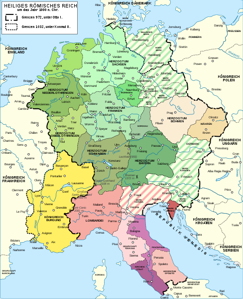
Deutsch: Karte des Heiligen Römischen Reiches um das Jahr 1000. English: Map of the Holy Roman Empire near year 1000. German version. Español: Mapa del Sacro Imperio Romano Germánico hacia el año 1000. Français : Carte du Saint-Empire romain germanique vers l'an mille (version allemand). Русский: Карта Священной Римской империи около 1000 года. |
|||
| Date | ||||
| Source |
Own work. Source :
|
|||
| Author | ||||
| Permission (Reusing this file) |
I, the copyright holder of this work, hereby publish it under the following licenses:
This file is licensed under the Creative Commons Attribution-Share Alike Attribution-Share Alike 4.0 International, 3.0 Unported, 2.5 Generic, 2.0 Generic and 1.0 Generic license.
You may select the license of your choice. |
|||
| Other versions |
Derivative works of this file: []
| |||
| Attribution (required by the license) | © Sémhur / Wikimedia Commons / | |||
| SVG development |


| Camera location | | View this and other nearby images on: OpenStreetMap |
|---|
File history
Click on a date/time to view the file as it appeared at that time.
| Date/Time | Thumbnail | Dimensions | User | Comment | |
|---|---|---|---|---|---|
| current | 12:58, 19 August 2016 | | 1,000 × 1,227 (458 KB) | Furfur (talk | contribs) | == {{int:filedesc}} == {{Information |Description={{Multilingual description |de=Karte des Heiligen Römischen Reiches um das Jahr 1000. |en= Map of the Holy Roman Empire near year 1000. Germa... |
You cannot overwrite this file.
File usage on Commons
The following 15 pages use this file:
- User:JMvanDijk
- File:Holy Roman Empire 1000 map-bg.svg
- File:Holy Roman Empire 1000 map-de.png
- File:Holy Roman Empire 1000 map-de.svg
- File:Holy Roman Empire 1000 map-es.svg
- File:Holy Roman Empire 1000 map-fr.svg
- File:Holy Roman Empire 1000 map-ka.svg
- File:Holy Roman Empire 1000 map-ko.svg
- File:Holy Roman Empire 1000 map-ru.svg
- File:Holy Roman Empire 1000 map-uk.svg
- File:Holy Roman Empire 1000 map with more colours-fr.svg
- File:Holy Roman Empire 11th century map-en.svg
- File:Holy Roman Empire 11th century map-hu.svg
- File:Holy Roman Empire 11th century map-zh-hans.svg
- Template:Other versions/Holy Roman Empire 1000 map
File usage on other wikis
The following other wikis use this file:
- Usage on azb.wikipedia.org
- Usage on de.wikipedia.org
- Usage on de.wikibooks.org
- Usage on it.wikipedia.org
- Usage on rm.wikipedia.org
- Usage on ro.wikipedia.org
- Usage on ru.wikipedia.org
- Usage on sv.wikipedia.org
- Usage on uk.wikipedia.org