File:History of Beijing Subway.gif
Jump to navigation
Jump to search
Size of this preview: 681 × 599 pixels. Other resolutions: 273 × 240 pixels | 546 × 480 pixels | 750 × 660 pixels.
Original file (750 × 660 pixels, file size: 111 KB, MIME type: image/gif, looped, 25 frames, 38 s)
Captions
Captions
Add a one-line explanation of what this file represents
Summary[edit]
| Description |
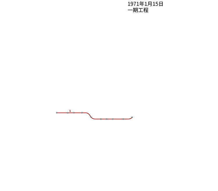
English: An animation that shows the history of Beijing Subway.
中文(中国大陆):表示北京地铁的历史的动画 |
| Date | |
| Source | Made on File:Beijing-Subway-Plan.svg |
| Author | Hat600 |
| Other versions |

|
This transport map image could be re-created using vector graphics as an SVG file. This has several advantages; see Commons:Media for cleanup for more information. If an SVG form of this image is available, please upload it and afterwards replace this template with
{{vector version available|new image name}}.
It is recommended to name the SVG file “History of Beijing Subway.svg”—then the template Vector version available (or Vva) does not need the new image name parameter. |
Licensing[edit]
I, the copyright holder of this work, hereby publish it under the following licenses:

|
Permission is granted to copy, distribute and/or modify this document under the terms of the GNU Free Documentation License, Version 1.2 or any later version published by the Free Software Foundation; with no Invariant Sections, no Front-Cover Texts, and no Back-Cover Texts. A copy of the license is included in the section entitled GNU Free Documentation License. |
This file is licensed under the Creative Commons Attribution-Share Alike Attribution-Share Alike 4.0 International, 3.0 Unported, 2.5 Generic, 2.0 Generic and 1.0 Generic license.
- You are free:
- to share – to copy, distribute and transmit the work
- to remix – to adapt the work
- Under the following conditions:
- attribution – You must give appropriate credit, provide a link to the license, and indicate if changes were made. You may do so in any reasonable manner, but not in any way that suggests the licensor endorses you or your use.
- share alike – If you remix, transform, or build upon the material, you must distribute your contributions under the same or compatible license as the original.
You may select the license of your choice.
|
File history
Click on a date/time to view the file as it appeared at that time.
| Date/Time | Thumbnail | Dimensions | User | Comment | |
|---|---|---|---|---|---|
| current | 10:24, 29 January 2019 | | 750 × 660 (111 KB) | Hat600 (talk | contribs) | update & redraw |
| 17:14, 30 December 2016 |  | 750 × 576 (64 KB) | Hat600 (talk | contribs) | upd | |
| 16:02, 26 December 2015 |  | 750 × 576 (62 KB) | Hat600 (talk | contribs) | upd | |
| 13:42, 1 January 2015 |  | 750 × 576 (66 KB) | Hat600 (talk | contribs) | upd | |
| 16:59, 27 December 2013 |  | 750 × 576 (62 KB) | Hat600 (talk | contribs) | update. there might be a remake before a next line comes to operation. | |
| 16:18, 4 May 2013 |  | 750 × 576 (58 KB) | Hat600 (talk | contribs) | hope it can still make a thumbnail | |
| 16:09, 29 December 2012 |  | 750 × 576 (55 KB) | Hat600 (talk | contribs) | upd | |
| 11:34, 1 January 2012 |  | 750 × 576 (48 KB) | Hat600 (talk | contribs) | update: 2011-12-31 | |
| 03:59, 25 July 2011 |  | 750 × 576 (66 KB) | Hat600 (talk | contribs) | mistaken date of 2000-06-28; some other changes. | |
| 14:07, 27 January 2011 |  | 750 × 576 (70 KB) | Hat600 (talk | contribs) | update per 2010-12-30 |
You cannot overwrite this file.
File usage on Commons
The following 10 pages use this file:
- User:Chumwa/OgreBot/Potential transport maps/2016 December 21-31
- User:Chumwa/OgreBot/Potential transport maps/2019 January 21-31
- User:Chumwa/OgreBot/Public transport information/2015 December 21-31
- User:Chumwa/OgreBot/Public transport information/2016 December 21-31
- User:Chumwa/OgreBot/Public transport information/2019 January 21-31
- User:Chumwa/OgreBot/Transport Maps/2015 December 21-31
- User:Chumwa/OgreBot/Transport Maps/2016 December 21-31
- User:Chumwa/OgreBot/Transport Maps/2019 January 21-31
- User:Chumwa/OgreBot/Travel and communication maps/2016 December 21-31
- User:Chumwa/OgreBot/Travel and communication maps/2019 January 21-31
File usage on other wikis
The following other wikis use this file:
- Usage on ja.wikipedia.org
- Usage on zh.wikipedia.org