File:High Speed Railroad Map Europe 2011.png
Jump to navigation
Jump to search

Size of this preview: 785 × 600 pixels. Other resolutions: 314 × 240 pixels | 628 × 480 pixels | 1,005 × 768 pixels | 1,280 × 978 pixels | 1,793 × 1,370 pixels.
Original file (1,793 × 1,370 pixels, file size: 294 KB, MIME type: image/png)
Captions
Captions
Add a one-line explanation of what this file represents
Summary[edit]
| Description |
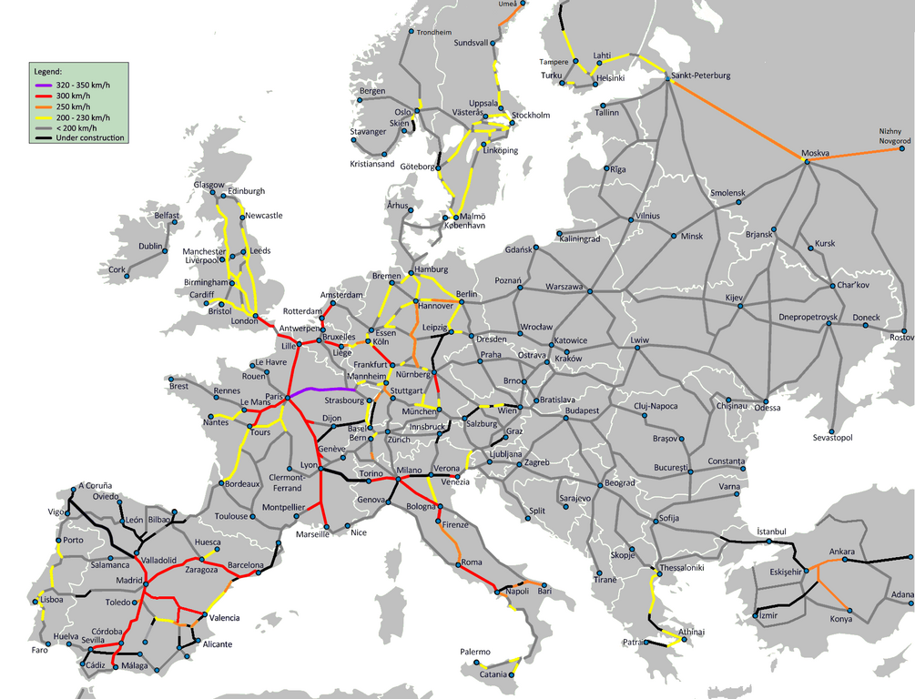
English: High Speed Railroad Network in Europe in 2011. Note: this map only includes tracks in operation in 2011, and is labeled with maximum allowed speed, not designed speed. Use maximum allowed speed, even if no trains have this speed for now. For clarity, some lines have been omitted. Deutsch: Europäisches Hochgeschwindigkeits-Bahnnetz (2011). Farben nach Höchstgeschwindigkeit. Español: Red de ferrocarriles de alta velocidad y velocidad alta en 2011. Nota: el mapa sólo incluye la máxima velocidad operativa (y no la efectiva o comercial) de las vías en el momento de realizarse |
| Date | (UTC) |
| Source | |
| Author |
|
| Other versions | High_Speed_Railroad_Map_Europe_2009.gif |
Licensing[edit]
This file is licensed under the Creative Commons Attribution-Share Alike 3.0 Unported license.
- You are free:
- to share – to copy, distribute and transmit the work
- to remix – to adapt the work
- Under the following conditions:
- attribution – You must give appropriate credit, provide a link to the license, and indicate if changes were made. You may do so in any reasonable manner, but not in any way that suggests the licensor endorses you or your use.
- share alike – If you remix, transform, or build upon the material, you must distribute your contributions under the same or compatible license as the original.
File history
Click on a date/time to view the file as it appeared at that time.
| Date/Time | Thumbnail | Dimensions | User | Comment | |
|---|---|---|---|---|---|
| current | 15:26, 25 July 2011 | | 1,793 × 1,370 (294 KB) | FlyAkwa (talk | contribs) | French line "Etampes-Vierzon" is also a 200 km/h line. Another Color change for 320-350 km/h lines for better visibility |
| 07:29, 10 July 2011 |  | 1,793 × 1,370 (412 KB) | Emturan (talk | contribs) | Color change for 250 km/h lines for better visibility | |
| 00:56, 19 June 2011 |  | 1,793 × 1,370 (411 KB) | Emturan (talk | contribs) | Design speed and maximum allowed speed on Turkish High Speed Network is 250 kmph. (Reference: http://hizlitren.tcdd.gov.tr/) | |
| 13:56, 8 June 2011 |  | 1,793 × 1,370 (411 KB) | Skgxt2 (talk | contribs) | Greece is "in". Please don't change it... | |
| 22:58, 20 May 2011 |  | 1,793 × 1,370 (320 KB) | Camoka4 (talk | contribs) | ||
| 23:59, 15 May 2011 |  | 1,793 × 1,370 (410 KB) | Skgxt2 (talk | contribs) | {{Information |Description={{en|1=High Speed Railroad Network in Europe in 2011. Note: this map only includes tracks in operation in 2011, and is labeled with maximum allowed speed, not designed speed. Use maximum allowed speed, even if no trains have thi | |
| 22:09, 21 December 2010 |  | 1,793 × 1,370 (409 KB) | BIL (talk | contribs) | Updated based on en:High-speed rail in Spain and de:Schnellfahrstrecke. Changes in Spain and Finland. | |
| 21:41, 12 December 2010 |  | 1,793 × 1,370 (411 KB) | BIL (talk | contribs) | Updated based on en:High-speed rail in Europe and de:Schnellfahrstrecke. Changed in Finland, Russia, Greece. Spain should still be updated. | |
| 12:01, 12 December 2010 |  | 1,793 × 1,370 (409 KB) | BIL (talk | contribs) | {{Information |Description={{en|1=High Speed Railroad Network in Europe in 2011. Note: this map only includes tracks in operation in 2011, and is labeled with maximum allowed speed, not designed speed. Use maximum allowed speed, even if no trains have thi |
You cannot overwrite this file.
File usage on Commons
The following 2 pages use this file:
File usage on other wikis
The following other wikis use this file:
- Usage on it.wikibooks.org