File:Heavy Sediment in the Adriatic Sea (MODIS).jpg
Original file (1,545 × 1,114 pixels, file size: 249 KB, MIME type: image/jpeg)
Captions
Captions
Summary
[edit].jpg&action=edit§ion=1)
| Description |
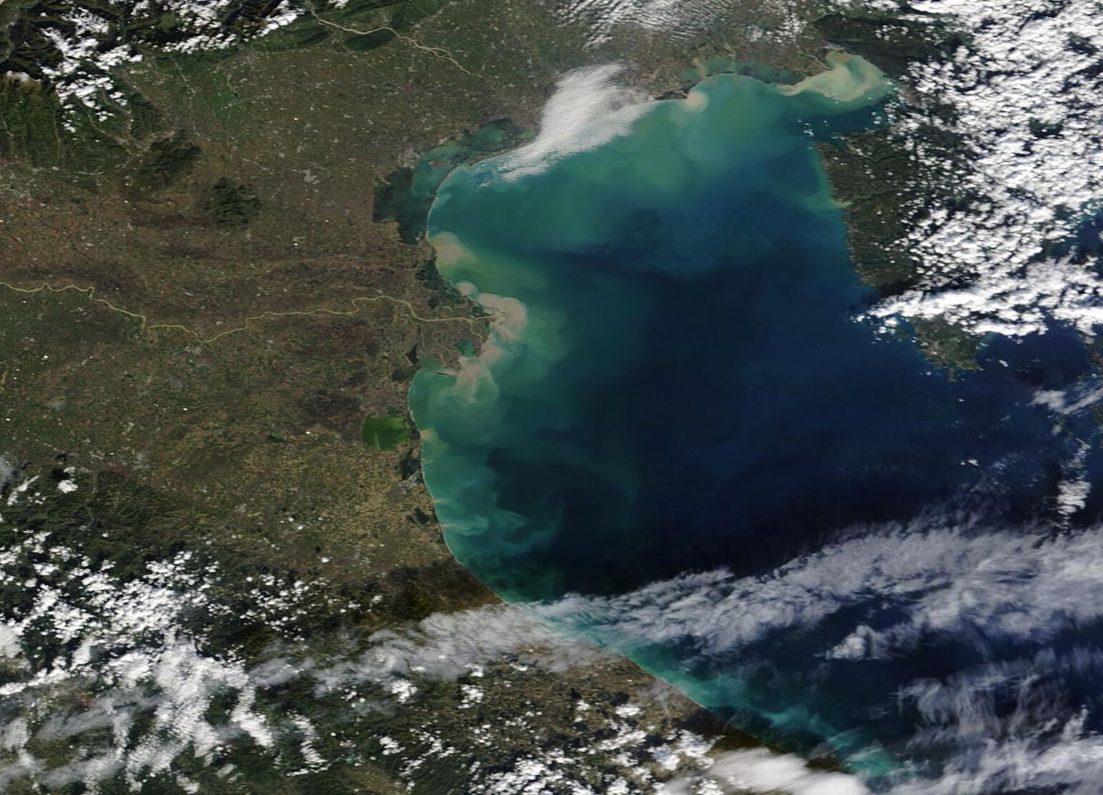
English: Storm Ciarán struck parts of Europe in late 2023, bringing extremely strong winds and heavy rain across a wide area. Peak winds of about 160 mph (260 km/h) were reported in the Channel Islands, an archipelago located in the English Channel off the Normandy coast of France. More than 1 million homes in France were left without electricity, according to media reports.
Italy was hit particularly hard. According to the Global Disaster Alert and Coordination System (GDACS), the heavy rainfall and strong winds affected northern Italy, especially Tuscany, Veneto, Liguria, and Emilia-Romagna regions, starting November 1. The storm caused widespread damage, including floods, overflowing rivers, landslides, and wind-related destruction, especially in Tuscany. On November 3, Floodlist reported that officials in Tuscany had declared a state of emergency after the region received torrential rain of about 200 mm (7.9 inches) in only 4 hours. At that time, several people were missing. As of November 6, GDACS reported that 1,200 people remained evacuated from their homes, seven people were confirmed as killed, and one person remained missing. The Moderate Resolution Imaging Spectroradiometer (MODIS) on NASA’s Terra satellite acquired a true-color image of the northern Adriatic Sea on November 6. Italy is located on the north and west of the Adriatic Sea. Sediment swirls along the shoreline due to the recent action of severe wind on coastal erosion as well creating waves that stirred up mud from the shallow areas of the Sea. Tan-colored sediment also spills into the Adriatic from the many rivers overburdened by mud from the recent floods and rain. The largest swirls are seen near the delta of the Po River, while the Po itself is filled with mud-colored water. Another eddy of brown just north of the Po delta comes from the Adige and Brenta Rivers. Further north, the sediment-laden Piave River can be seen flowing eastward toward the Adriatic Sea. |
||
| Date | Taken on 6 November 2023 | ||
| Source |
Heavy Sediment in the Adriatic Sea (direct link)
|
||
| Author | MODIS Land Rapid Response Team, NASA GSFC |
| This media is a product of the Terra mission Credit and attribution belongs to the mission team, if not already specified in the "author" row |
Licensing
[edit].jpg&action=edit§ion=2)
| This file is in the public domain in the United States because it was solely created by NASA. NASA copyright policy states that "NASA material is not protected by copyright unless noted". (See Template:PD-USGov, NASA copyright policy page or JPL Image Use Policy.) | ||
 |
Warnings:
|
File history
Click on a date/time to view the file as it appeared at that time.
| Date/Time | Thumbnail | Dimensions | User | Comment | |
|---|---|---|---|---|---|
| current | 05:05, 11 November 2023 | | 1,545 × 1,114 (249 KB) | OptimusPrimeBot (talk | contribs) | #Spacemedia - Upload of http://modis.gsfc.nasa.gov/gallery/images/image11112023_250m.jpg via Commons:Spacemedia |
You cannot overwrite this file.
File usage on Commons
There are no pages that use this file.
.jpg&oldid=820643382)