File:Havana on the Island of Cuba WDL10080.png
Jump to navigation
Jump to search

Size of this preview: 800 × 576 pixels. Other resolutions: 320 × 231 pixels | 640 × 461 pixels | 1,024 × 738 pixels | 1,280 × 922 pixels | 1,421 × 1,024 pixels.
Original file (1,421 × 1,024 pixels, file size: 2.33 MB, MIME type: image/png)
Captions
Captions
Add a one-line explanation of what this file represents
Summary
[edit]
| Author |
Русский: Винкебунс, Джоан, 1617—1670 гг.
Français : Vinckeboons, Joan, 1617-1670
English: Vinckeboons, Joan, 1617-1670
中文:琼·维奇布斯,1617-1670 年
Português: Vinckeboons, Joan, 1617-1670
العربية: جون فينكيبونز، 1617-1670
Español: Vinckeboons, Joan, 1617-1670 |
| Title |
Русский: Гавана на острове Куба
Français : La Havane sur l'île de Cuba
English: Havana on the Island of Cuba
中文:古巴岛上的哈瓦那
Português: Havana na ilha de Cuba
العربية: هافانا على جزيرة كوبا
Español: La Habana en la isla de Cuba |
| Description |
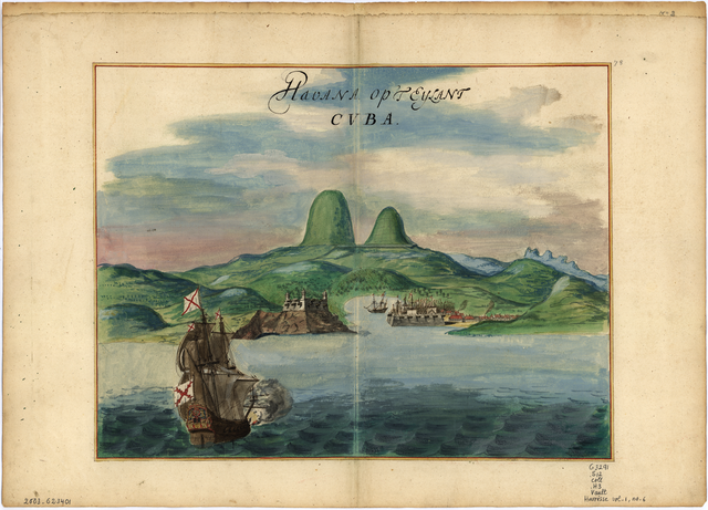
Русский: Джоан Винкебунс (1617—1670 гг.), голландский картограф и гравер, родился в семье художников фламандского происхождения. Он работал на голландскую Вест-Индскую компанию и в течение более 30 лет составлял карты, которые использовались для торговых и военных транспортных перевозок. Он также был деловым партнером Джоана Блау, одного из самых известных издателей карт и атласов того времени. Винкебунс создал целую серию из 200 рукописных карт, которые использовались для составления атласов, в том числе и знаменитого атласа Блау "Atlas Maior". На этой карте, выполненной около 1639 г. с помощью пера, туши и акварели, представлен панорамный вид порта Гаваны и окрестностей. На карте выделены мощные укрепления, защищающие город, и отмечены городские строения, корабли, бухта и близлежащие окрестности, а также географически неточно размещенные горные пики, нависающие над бухтой. Рельеф изображен как графически, так и с помощью гипсометрической окраски. Карта была частью рукописного атласа, принадлежавшего голландской фирме Герарда Хюлста ван Келена, которая публиковала морские атласы и справочники судоходства на протяжении двух столетий. После передачи фирмы по наследству атлас приобрел и разобрал на отдельные карты книготорговец из Амстердама Фредерик Мюллер, который в 1887 г. продал 13 карт из атласа, автором которого считается Винкебунс, коллекционеру и библиографу Генри Харриссу. Карта является частью коллекции Генри Харрисса, хранящейся в Библиотеке Конгресса.
Крепости и фортификационные сооружения; Острова; Рукописные карты; Иллюстрированные карты; Корабли Français : Joan Vinckeboons (1617-1670) était un cartographe et graveur néerlandais issu d'une famille d'artistes d'origine flamande. Employé de la Compagnie néerlandaise des Indes occidentales, il a produit pendant plus de 30 ans des cartes destinées à la marine militaire et marchande néerlandaise. Il a travaillé avec Joan Blaeu, l'un des plus importants éditeurs de cartes et d'atlas de l'époque. Vinckeboons a dressé une série de 200 cartes manuscrites qui ont été reproduites dans plusieurs atlas, dont le célèbre Atlas Maior de Blaeu. Cette carte, datant de 1639 environ, dessinée à la plume et à l'encre et peinte à l'aquarelle montre une vue panoramique du port de La Havane et ses alentours. Elle met en évidence les fortifications imposantes protégeant la ville et montre les bâtiments de la ville, des navires, le port et le paysage environnant, avec des pics géographiquement inexacts surgissant au-dessus du port. Le relief est représenté par des images et des dégradés de nuances. Cette carte faisait partie d'un atlas manuscrit appartenant à l'entreprise néerlandaise de Gerard Hulst van Keulen, qui publia des atlas marins et des manuels de navigation pendant plus de deux siècles. À la disparition de l'entreprise, l'atlas fut racheté et fragmenté par le libraire d'Amsterdam Frederik Muller qui, en 1887, vendit 13 cartes de l'atlas attribuées à Vinckeboons au collectionneur et bibliographe Henry Harrisse. Cette carte fait partie de la collection Henry Harrisse à la Bibliothèque du Congrès.
Forts et fortifications; Îles; Cartes manuscrites; Cartes picturales; Navires English: Joan Vinckeboons (1617–70) was a Dutch cartographer and engraver born into a family of artists of Flemish origin. He was employed by the Dutch West India Company and for more than 30 years produced maps for use by Dutch mercantile and military shipping. He was a business partner of Joan Blaeu, one of the most important map and atlas publishers of the day. Vinckeboons drew a series of 200 manuscript maps that were used in the production of atlases, including Blaeu’s Atlas Maior. This pen-and-ink and watercolor map from around 1639 shows a panoramic view of Havana harbor and vicinity. The map emphasizes the strong fortifications protecting the city, and shows city buildings, ships, the harbor, and the nearby countryside, with geographically inaccurate peaks looming over the harbor. Relief is shown pictorially and by gradient tints. The map was once part of a manuscript atlas belonging to the Dutch firm of Gerard Hulst van Keulen, which published sea atlases and navigational handbooks for over two centuries. With the demise of the firm, the atlas was acquired and broken up by the Amsterdam book dealer Frederik Muller, who in 1887 sold 13 maps from the atlas attributed to Vinckeboons to the collector and bibliographer Henry Harrisse. This map is part of the Henry Harrisse Collection in the Library of Congress.
Forts and fortifications; Islands; Manuscript maps; Pictorial maps; Ships 中文:琼·维奇布斯(Joan Vinckeboons,1617-1670 年)是荷兰人,出生于一个传统的佛兰芒艺术家庭,是一位制图师和雕刻师。他曾受雇于荷兰西印度公司,绘制地图逾 30 年,供荷兰的商业和军事运输使用。他是当时最重要的地图与地图集出版商之一琼·布劳 (Joan Blaeu) 的商业伙伴。维奇布斯绘制了一个系列的 200 张手绘地图,用于制作地图集,包括布劳的《大地图集》。这张 1639 年左右的笔墨水彩地图绘制的是哈瓦那港及周边地区的全景。地图重点标示了保护城市的坚固工事,并显示了城市的建筑物、船舶、海港、附近的乡村,以及俯视着海港、具体地理位置不正确的山峰。地势由图示和渐变的色彩示出。这张地图曾经是属于杰勒德·赫尔斯特·范格伦 (Gerard Hulst van Keulen) 荷兰公司的手绘地图集的一部分,范格伦出版各种海洋地图和导航手册的历史有两个多世纪。随着该公司的消亡,地图集被阿姆斯特丹书商弗雷德里克·穆勒 (Frederik Muller) 收购和分开,他在 1887 年向收藏家和书志编纂家亨利·哈里斯 (Henry Harrisse) 出售了该地图集中维奇布斯绘制的 13 张图。此地图是美国国会图书馆亨利·哈里斯收藏集的一部分。
堡垒和防御工事; 岛屿; 手绘地图; 图示地图; 船舶 Português: Joan Vinckeboons (1617-1670) foi um cartógrafo e gravador holandês nascido em uma família de artistas de origem flamenga. Ele foi empregado pela Companhia Holandesa das Índias Ocidentais e por mais de 30 anos produziu mapas para utilização pela marinha mercantil e militar holandesa. Ele foi parceiro de negócios de Joan Blaeu, um dos mais importantes editores de mapas e atlas até então. Vinckeboons desenhou uma série de 200 mapas manuscritos que foram usados na produção de atlas, incluindo o Atlas Maior de Blaeu. Este mapa em bico de pena e aquarela de cerca de 1639 mostra uma vista panorâmica do porto de Havana e arredores. O mapa destaca as sólidas fortalezas que protegem a cidade e mostra os edifícios da cidade, navios, o porto e a zona rural nas proximidades, com picos geograficamente imprecisos cercando o porto. O relevo é mostrado pictoricamente através de matizes gradientes. O mapa já fez parte de um atlas manuscrito que pertencia à empresa holandesa de Gerard van Keulen Hulst, que publicou atlas marítimos e manuais de navegação por mais de dois séculos. Com o fim da empresa, o atlas foi adquirido e fragmentado pelo revendedor de livros de Amsterdã Frederik Muller, que em 1887 vendeu 13 mapas do atlas atribuídos a Vinckeboons ao colecionador e bibliógrafo Henry Harrisse. Este mapa é parte da Coleção Henry Harrisse da Biblioteca do Congresso.
Fortes e fortificações; Ilhas; Mapas manuscritos; Mapas pictóricos; Navios العربية: كان جون فينكيبونز (1617–1670) رسام خرائط ونحاتاً هولندياً وُلِد في عائلة من الفنانين من أصل فلمنكي. قامت شركة داتش ويست إنديا بتعيينه، ولمدة تزيد عن 30 عاماً أَنتج جون خرائط استُخدِمَت في الشحن البحري التجاري والعسكري. كان شريكاً تجارياً لجون بلو، أحد أهم ناشري الخرائط والأطالس حينئذ. رَسَم فينكيبونز مجموعة مكونة من 200 خريطة مخطوطة استُخدِمَت في إنتاج أطالس، بما في ذلك أطلس مايور الخاص بِبلو. تُظهِر هذه الخريطة، المرسومة بالقلم الجاف والحبر والألوان المائية من حوالي العام 1639، منظراً بانورامياً لميناء هافانا والمناطق المجاورة له. تُبرِز الخريطة الحصون القوية التي تحمي المدينة، وتُظهِر مباني المدينة وسفنها وميناءها، والمنطقة الريفية المجاورة، مع قمم غير دقيقة جغرافياً تطل على الميناء. تَظهر التضاريس بشكل تصويري وباستخدام درجات من الألوان. كانت الخريطة جزءاً من مخطوطة أطلس ترجع ملكيته إلى شركة جيرارد هالست فان كويلن الهولندية، التي نَشَرَت أطالس بحرية وكتيِّبات ملاحية على مدار أكثر من قرنين. مع انهيار المؤسسة، حصل متعهد الكُتُب فريدريك مولر من أمستردام على الأطلس وفككه، حيث باع 13 خريطة من الأطلس المنسوب إلى فينكيبونز لجامع الأعمال وعالم الكُتُب هنري هاريس عام 1887. توجَد هذه المخطوطة ضمن مجموعة هنري هاريس في مكتبة الكونغرس.
الحصون والتحصينات; الجزر; الخرائط المخطوطة; خرائط مصورة; السفن Español: Joan Vinckeboons (1617-1670) fue un cartógrafo y grabador holandés proveniente de una familia de artistas de origen flamenco. Estaba empleado en la Compañía Neerlandesa de las Indias Occidentales y confeccionó mapas por más de 30 años para su utilización en el transporte mercantil y militar holandés. Fue compañero de negocios de Joan Blaeu, uno de los editores de mapas y atlas más importantes de la época. Vinckeboons dibujó una serie de 200 mapas manuscritos que se utilizaron en la producción de atlas, incluida la obra de Blaeu, Atlas Maior. Este mapa en pluma y tinta y acuarela que data de alrededor de 1639 muestra una vista panorámica de La Habana y sus alrededores. El mapa destaca las fortificaciones que protegían la ciudad, y muestra edificios de la ciudad, barcos, el puerto y la campiña cercana, con picos que se ciernen sobre el puerto colocados sin exactitud geográfica. El relieve se muestra gráficamente y por tonos degradados. En algún momento el mapa fue parte de un atlas manuscrito perteneciente a la empresa holandesa de Gerard Hulst van Keulen, que publicó atlas marinos y manuales de navegación por más de dos siglos. Cuando se disolvió de la empresa, el atlas fue adquirido y dividido por Frederik Muller, un comerciante de libros de Ámsterdam. Muller desarmó el atlas y, en 1887, vendió al coleccionista y bibliógrafo Henry Harrisse 13 de los mapas del atlas que se atribuye a Vinckeboons. Este mapa pertenece a la Colección Henry Harrisse de la Biblioteca del Congreso.
Fuertes y fortificaciones; Islas; Mapas manuscritos; Mapas pictóricos; Buques |
| Date | 1639 |
| Medium |
Русский: Карты
Français : Cartes
English: Maps
中文:地图
Português: Mapas
العربية: خرائط
Español: Mapas |
| Dimensions |
English: 1 manuscript : color, paper backing ; 41 x 54 centimeters |
| Collection |
Русский: Библиотека Конгресса
Français : Bibliothèque du Congrès
English: Library of Congress
中文:国会图书馆
Português: Biblioteca do Congresso
العربية: مكتبة الكونغرس
Español: Biblioteca del Congreso |
| Current location |
Русский: Коллекция Генри Харрисса
Français : Collection Henry Harrisse
English: Henry Harrisse Collection
中文:亨利·哈里斯收藏集
Português: Coleção Henry Harrisse
العربية: Henry Harrisse Collection
Español: Colección Henry Harrisse |
| Place of creation |
Русский: Гавана
Français : La Havane
English: Havana
中文:哈瓦那
Português: Havana
العربية: هافانا
Español: La Habana |
| Notes |
Original language title: Havana op 't Eyland Cvba Русский: Масштаб не указан.
Français : Échelle non indiquée.
English: Scale not given.
中文:未提供比例尺。
Português: Escala não fornecida.
العربية: المقياس غير معروف.
Español: No se da la escala. |
| References | http://hdl.loc.gov/loc.wdl/dlc.10080 |
| Source/Photographer |
|
Licensing
[edit]
|
This is a faithful photographic reproduction of a two-dimensional, public domain work of art. The work of art itself is in the public domain for the following reason:
The official position taken by the Wikimedia Foundation is that "faithful reproductions of two-dimensional public domain works of art are public domain".
This photographic reproduction is therefore also considered to be in the public domain in the United States. In other jurisdictions, re-use of this content may be restricted; see Reuse of PD-Art photographs for details. | ||||
File history
Click on a date/time to view the file as it appeared at that time.
| Date/Time | Thumbnail | Dimensions | User | Comment | |
|---|---|---|---|---|---|
| current | 10:13, 10 March 2014 | | 1,421 × 1,024 (2.33 MB) | Fæ (talk | contribs) | =={{int:filedesc}}== {{Artwork |artist = |author ={{ru|1=Винкебунс, Джоан, 1617—1670 гг.}} {{fr|1=Vinckeboons, Joan, 1617-1670}} {{en|1=Vinckeboons, Joan, 1617-1670}} {{zh|1=琼·维奇布斯,1617-1670 年}} {{pt|1=Vinckeboons, Joa... |
You cannot overwrite this file.
File usage on Commons
The following 2 pages use this file:
File usage on other wikis
The following other wikis use this file:
- Usage on eu.wikipedia.org