File:Hannover Stadtbahn B Sued.png
Jump to navigation
Jump to search
Size of this preview: 371 × 600 pixels. Other resolutions: 148 × 240 pixels | 297 × 480 pixels | 475 × 768 pixels | 1,169 × 1,890 pixels.
Original file (1,169 × 1,890 pixels, file size: 634 KB, MIME type: image/png)
Captions
Captions
Add a one-line explanation of what this file represents
| Description |
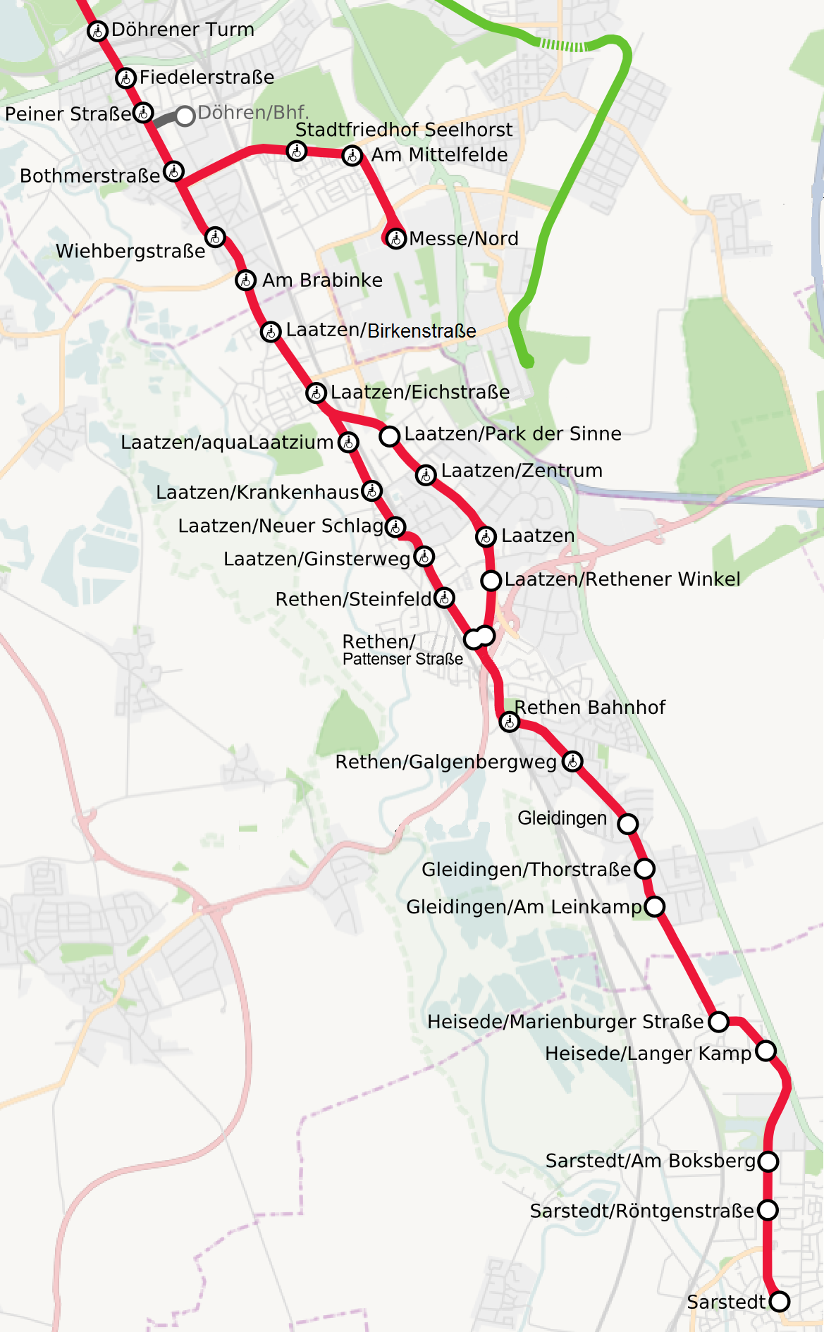
English: Light rail of Hannover, Germany. B South
Deutsch: Stadtbahn Hannover, Teilnetz B Süd |
||||||||||||
| Date | |||||||||||||
| Source | Own work, background: OpenStreetMap data | ||||||||||||
| Author | Jeremiah21 | ||||||||||||
| Permission (Reusing this file) |
|

|
This transport map image could be re-created using vector graphics as an SVG file. This has several advantages; see Commons:Media for cleanup for more information. If an SVG form of this image is available, please upload it and afterwards replace this template with
{{vector version available|new image name}}.
It is recommended to name the SVG file “Hannover Stadtbahn B Sued.svg”—then the template Vector version available (or Vva) does not need the new image name parameter. |

|
This map has been made or improved in the German Kartenwerkstatt (Map Lab). You can propose maps to improve as well.
|
File history
Click on a date/time to view the file as it appeared at that time.
| Date/Time | Thumbnail | Dimensions | User | Comment | |
|---|---|---|---|---|---|
| current | 16:52, 12 February 2024 | | 1,169 × 1,890 (634 KB) | NordNordWest (talk | contribs) | upload for User:Nixblicker |
| 22:35, 6 August 2023 |  | 1,169 × 1,890 (668 KB) | Nixblicker (talk | contribs) | Schleife und Haltestelle Rethen aufgegeben | |
| 23:00, 18 November 2022 |  | 1,169 × 1,890 (853 KB) | Nixblicker (talk | contribs) | Hochbahnsteig Rethen/Steinfeld | |
| 18:57, 17 December 2020 |  | 1,169 × 1,890 (853 KB) | Nixblicker (talk | contribs) | Hochbahnsteig Rethen/Galgenbergweg eröffnet | |
| 23:59, 15 December 2019 |  | 1,169 × 1,890 (853 KB) | Nixblicker (talk | contribs) | Laatzen/Eichstraße ohne Zusatz Bahnhof | |
| 10:45, 15 October 2018 |  | 1,169 × 1,890 (855 KB) | Nixblicker (talk | contribs) | Hochbahnsteig Laatzen eröffnet | |
| 00:22, 19 December 2017 |  | 1,169 × 1,890 (855 KB) | Nixblicker (talk | contribs) | Laatzen/Werner-von-Siemens-Platz umbenannt in Laatzen/Birkenstraße | |
| 23:05, 27 November 2015 |  | 1,169 × 1,890 (731 KB) | Nixblicker (talk | contribs) | Hochbahnsteige Rethen/Bahnhof eingefügt | |
| 13:10, 2 August 2013 |  | 1,179 × 1,902 (984 KB) | Nixblicker (talk | contribs) | Grafikfehler entfernt | |
| 13:06, 2 August 2013 |  | 1,179 × 1,902 (985 KB) | Nixblicker (talk | contribs) | Haltestellenname "Am Brabrinke" korrigiert |
You cannot overwrite this file.
File usage on Commons
The following 27 pages use this file:
- User:Chumwa/OgreBot/Potential transport maps/2017 December 11-20
- User:Chumwa/OgreBot/Potential transport maps/2018 October 11-20
- User:Chumwa/OgreBot/Potential transport maps/2019 December 11-20
- User:Chumwa/OgreBot/Public transport information/2015 November 21-30
- User:Chumwa/OgreBot/Public transport information/2017 December 11-20
- User:Chumwa/OgreBot/Public transport information/2018 October 11-20
- User:Chumwa/OgreBot/Public transport information/2019 December 11-20
- User:Chumwa/OgreBot/Public transport information/2020 December 11-20
- User:Chumwa/OgreBot/Public transport information/2022 November 11-20
- User:Chumwa/OgreBot/Public transport information/2023 August 1-10
- User:Chumwa/OgreBot/Public transport information/2024 February 10-19
- User:Chumwa/OgreBot/Transport Maps/2015 November 21-30
- User:Chumwa/OgreBot/Transport Maps/2017 December 11-20
- User:Chumwa/OgreBot/Transport Maps/2018 October 11-20
- User:Chumwa/OgreBot/Transport Maps/2019 December 11-20
- User:Chumwa/OgreBot/Transport Maps/2020 December 11-20
- User:Chumwa/OgreBot/Transport Maps/2022 November 11-20
- User:Chumwa/OgreBot/Transport Maps/2023 August 1-10
- User:Chumwa/OgreBot/Transport Maps/2024 February 10-19
- User:Chumwa/OgreBot/Travel and communication maps/2017 December 11-20
- User:Chumwa/OgreBot/Travel and communication maps/2018 October 11-20
- User:Clic/Nahverkehr in Deutschland/2019 December 11-20
- User:Clic/Nahverkehr in Deutschland/2020 December 11-20
- User:Clic/Nahverkehr in Deutschland/2022 November 11-20
- User:Clic/Nahverkehr in Deutschland/2023 August 1-10
- User:Clic/Nahverkehr in Deutschland/2024 February 10-19
- User:Nordlicht8/Rail Germany/2015 November 21-30
File usage on other wikis
The following other wikis use this file:
- Usage on de.wikipedia.org