File:Hall Islands Landsat.jpg
Jump to navigation
Jump to search

Size of this preview: 800 × 449 pixels. Other resolutions: 320 × 179 pixels | 640 × 359 pixels | 1,200 × 673 pixels.
Original file (1,200 × 673 pixels, file size: 140 KB, MIME type: image/jpeg)
Captions
Captions
Add a one-line explanation of what this file represents
Summary
[edit]
| Description |
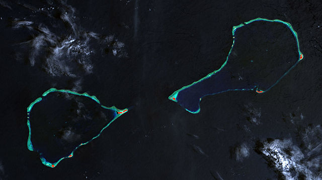
Deutsch: Landsat-7-Bild der Hall-Inseln, bestehend aus den Atollen Nomwin (links) und Murilo (rechts), Staat Chuuk, Föderierte Staaten von Mikronesien
English: Landsat 7 image of Hall Islands which consist of the two atolls Nowin (left) and Murilo (right), Chuuk State, Federated States of Micronesia |
| Date | |
| Source | http://www.oceandots.com/pacific/caroline/murilo3.php |
| Author | NASA millenium coral reefs landsat archive |
Licensing
[edit]
| This file is in the public domain in the United States because it was solely created by NASA. NASA copyright policy states that "NASA material is not protected by copyright unless noted". (See Template:PD-USGov, NASA copyright policy page or JPL Image Use Policy.) | ||
 |
Warnings:
|
| Annotations | This image is annotated: View the annotations at Commons |
File history
Click on a date/time to view the file as it appeared at that time.
| Date/Time | Thumbnail | Dimensions | User | Comment | |
|---|---|---|---|---|---|
| current | 19:36, 30 January 2010 | | 1,200 × 673 (140 KB) | Telim tor (talk | contribs) | == {{int:filedesc}} == {{Information |Description= {{de|Landsat-7-Bild der Hall-Inseln, bestehend aus den Atollen Nomwin (links) und Murilo (rechts), Staat Chuuk, Föderierte Staaten von Mikronesien}} {{en|Landsat 7 image of Hall Islands which consist of |
You cannot overwrite this file.
File usage on Commons
The following page uses this file:
File usage on other wikis
The following other wikis use this file:
- Usage on de.wikipedia.org
- Usage on en.wikipedia.org
- Usage on es.wikipedia.org
- Usage on fa.wikipedia.org
- Usage on fr.wikipedia.org
- Usage on ja.wikipedia.org
- Usage on lv.wikipedia.org
- Usage on mk.wikipedia.org
- Usage on tr.wikipedia.org
- Usage on www.wikidata.org
- Usage on zh.wikipedia.org