File:Haiti and Dominican Republic (MODIS 2016-02-07).jpg
Jump to navigation
Jump to search

Size of this preview: 794 × 600 pixels. Other resolutions: 318 × 240 pixels | 636 × 480 pixels | 1,017 × 768 pixels | 1,280 × 967 pixels | 2,560 × 1,934 pixels | 3,172 × 2,396 pixels.
Original file (3,172 × 2,396 pixels, file size: 972 KB, MIME type: image/jpeg)
Captions
Captions
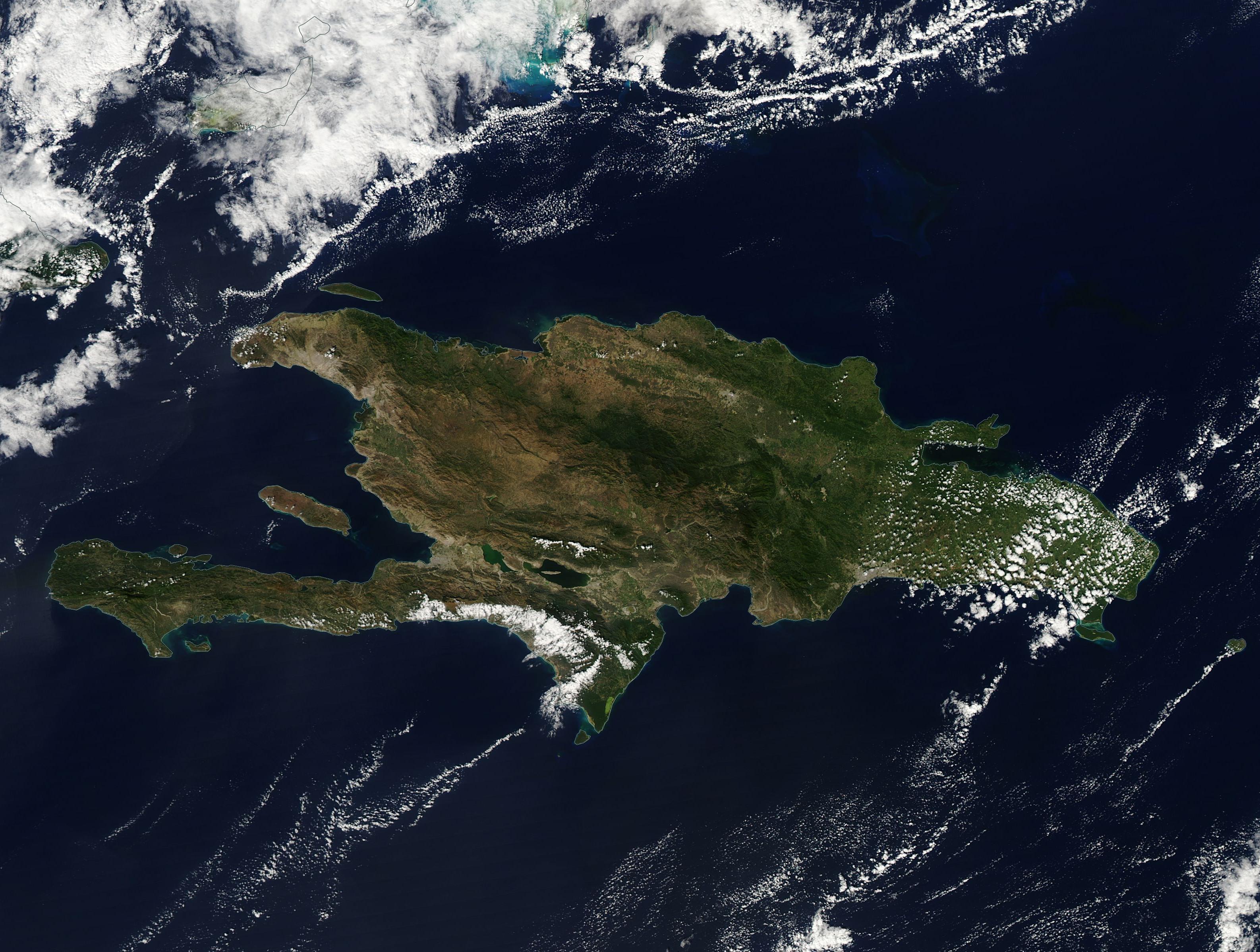
On January 19, 2016, the Moderate Resolution Imaging Spectroradiometer (MODIS) aboard NASA�s Aqua satellite flew over the West Indies and captured this beautiful clear-sky image of the island of Hispaniola.
Summary
[edit].jpg&action=edit§ion=1)
| Description |
English: On January 19, 2016, the Moderate Resolution Imaging Spectroradiometer (MODIS) aboard NASA�s Aqua satellite flew over the West Indies and captured this beautiful clear-sky image of the island of Hispaniola.
The second-largest island in the Caribbean, Hispaniola is home to two countries. The Dominican Republic lies in the eastern two-thirds of the island, and Haiti occupies the western third. The terrain is rugged, with five major mountain ranges that stretch across the island, interspersed with steep and typically fertile valleys. The arrangement, height and ruggedness of the terrain makes travel from south to north difficult. The Dominican Republic is about twice the size of the state of New Hampshire, with 51.5% of the land used for agriculture, with just over 10% in permanent crops and almost 25% in permanent pasture. Forests cover about 40.8% of the Dominican Republic. Haiti is slightly smaller than the state of Maryland, with 66.4% of land in agricultural use. Permanent crops account for just over 10% of agricultural land, and permanent pasture about 17.7 %. In contrast to the Dominican Republic, Haiti�s land is only 3.6% forested. |
||
| Date | Taken on 19 January 2016 | ||
| Source |
Haiti and Dominican Republic (direct link)
|
||
| Author | Jeff Schmaltz, MODIS Land Rapid Response Team, NASA GSFC |
| This media is a product of the Aqua mission Credit and attribution belongs to the mission team, if not already specified in the "author" row |
Licensing
[edit].jpg&action=edit§ion=2)
| This file is in the public domain in the United States because it was solely created by NASA. NASA copyright policy states that "NASA material is not protected by copyright unless noted". (See Template:PD-USGov, NASA copyright policy page or JPL Image Use Policy.) | ||
 |
Warnings:
|
File history
Click on a date/time to view the file as it appeared at that time.
| Date/Time | Thumbnail | Dimensions | User | Comment | |
|---|---|---|---|---|---|
| current | 19:46, 15 February 2024 | | 3,172 × 2,396 (972 KB) | OptimusPrimeBot (talk | contribs) | #Spacemedia - Upload of http://modis.gsfc.nasa.gov/gallery/images/image02072016_250m.jpg via Commons:Spacemedia |
You cannot overwrite this file.
File usage on Commons
There are no pages that use this file.
.jpg&oldid=852075474)