File:Hainaut centre SNCV openstreetmap.png
Jump to navigation
Jump to search
Size of this preview: 426 × 600 pixels. Other resolutions: 170 × 240 pixels | 341 × 480 pixels | 545 × 768 pixels | 727 × 1,024 pixels | 1,456 × 2,050 pixels.
Original file (1,456 × 2,050 pixels, file size: 2.71 MB, MIME type: image/png)
Captions
Captions
Add a one-line explanation of what this file represents
Summary[edit]
| Description |
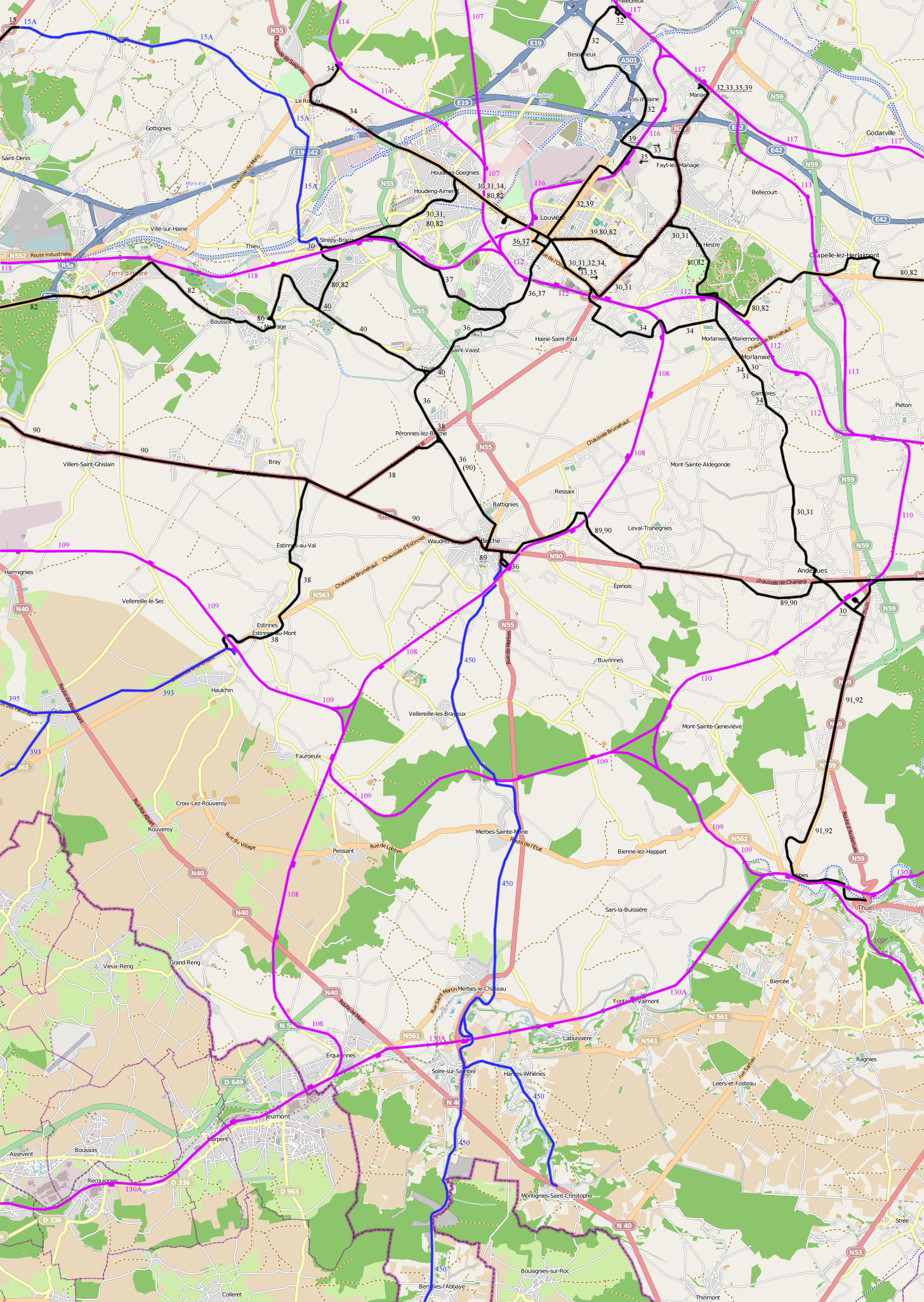
English: Map showing the vicinal tram routes in the Hainaut Centre area at the maximum extent. Not all lines where open at the same time and some routes were changed. The electric lines are as in 1947. This is with a openstreetmap background.
The black lines are electric, the blue lines non-electric lines and the red lines railways.
Nederlands: Kaart die de maximale uitbreiding van het tramnet in de Henegouwen Centre streek toont. Niet alle routes zijn gelijktijdig open en sommige routes zijn gewijzigd. De achtergrond is een openstreetmap.
De zwarte lijnen zijn elektrisch, de blauwe niet-elektrisch en de rode spoorwegen. |
| Date | |
| Source | Own work |
| Author | Smiley.toerist |
| Permission (Reusing this file) |
All OpenStreetMap data and maps are Creative Commons "CC-BY-SA 2.0" licensed |
| Other versions | original import: File:Hainaut Centre.png, without openstreet background: File:Hainaut centre SNCV names.png |
Licensing[edit]
I, the copyright holder of this work, hereby publish it under the following licenses:

|
Permission is granted to copy, distribute and/or modify this document under the terms of the GNU Free Documentation License, Version 1.2 or any later version published by the Free Software Foundation; with no Invariant Sections, no Front-Cover Texts, and no Back-Cover Texts. A copy of the license is included in the section entitled GNU Free Documentation License. |
This file is licensed under the Creative Commons Attribution-Share Alike 3.0 Unported, 2.5 Generic, 2.0 Generic and 1.0 Generic license.
- You are free:
- to share – to copy, distribute and transmit the work
- to remix – to adapt the work
- Under the following conditions:
- attribution – You must give appropriate credit, provide a link to the license, and indicate if changes were made. You may do so in any reasonable manner, but not in any way that suggests the licensor endorses you or your use.
- share alike – If you remix, transform, or build upon the material, you must distribute your contributions under the same or compatible license as the original.
You may select the license of your choice.
File history
Click on a date/time to view the file as it appeared at that time.
| Date/Time | Thumbnail | Dimensions | User | Comment | |
|---|---|---|---|---|---|
| current | 13:09, 15 August 2011 | | 1,456 × 2,050 (2.71 MB) | Smiley.toerist (talk | contribs) | Connection line 80 and 82 added + route in Gougnies changed |
| 14:25, 11 August 2011 |  | 1,456 × 2,050 (2.7 MB) | Smiley.toerist (talk | contribs) | {{Information |Description ={{en|1=Map showing the vicinal tram routes in the Hainaut Centre area at the maximum extent. Not all lines where open at the same time and some routes were changed. The electric lines are as in 1947. This is with a openstree |
You cannot overwrite this file.
File usage on Commons
The following 3 pages use this file:
File usage on other wikis
The following other wikis use this file:
- Usage on fr.wikipedia.org
- Lignes de tramway de la SNCV dans la province de Hainaut
- Ligne de tramway 30 (SNCV Groupe du Centre)
- Ligne de tramway 40 (SNCV Groupe du Centre)
- Ligne de tramway 39 (SNCV Groupe du Centre)
- Ligne de tramway 38 (SNCV Groupe du Centre)
- Ligne de tramway 37 (SNCV Groupe du Centre)
- Ligne de tramway 36A
- Ligne de tramway 36 (SNCV Groupe du Centre)
- Ligne de tramway 34 (SNCV Groupe du Centre)
- Ligne de tramway 33/35
- Ligne de tramway 32 (SNCV Groupe du Centre)