File:Hadrians Wall map-fi.png
Jump to navigation
Jump to search

Size of this preview: 482 × 599 pixels. Other resolutions: 193 × 240 pixels | 386 × 480 pixels.
Original file (800 × 995 pixels, file size: 250 KB, MIME type: image/png)
Captions
Captions
Add a one-line explanation of what this file represents
Summary[edit]
| Description |
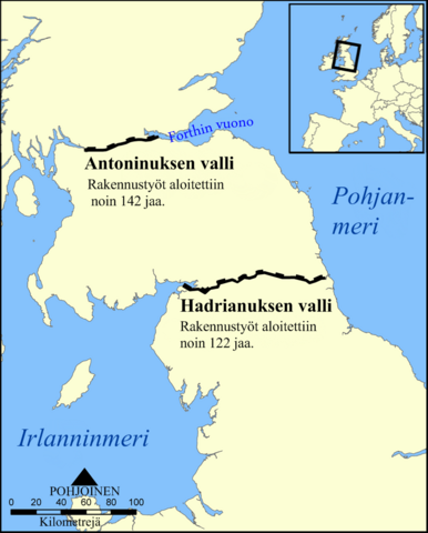
English: This map shows the location of Hadrian's Wall and the Antonine Wall in Scotland and Northern England.
|
| Date | |
| Source | Translated from File:Hadrians Wall map.png. |
| Author | Original:' User:NormanEinstein, Translated version: User:Barosaurus Lentus |
| Other versions | File:Hadrians Wall map.png |
Licensing[edit]
This file is licensed under the Creative Commons Attribution-Share Alike 3.0 Unported license.
- You are free:
- to share – to copy, distribute and transmit the work
- to remix – to adapt the work
- Under the following conditions:
- attribution – You must give appropriate credit, provide a link to the license, and indicate if changes were made. You may do so in any reasonable manner, but not in any way that suggests the licensor endorses you or your use.
- share alike – If you remix, transform, or build upon the material, you must distribute your contributions under the same or compatible license as the original.
File history
Click on a date/time to view the file as it appeared at that time.
| Date/Time | Thumbnail | Dimensions | User | Comment | |
|---|---|---|---|---|---|
| current | 15:27, 29 September 2009 | | 800 × 995 (250 KB) | Barosaurus Lentus (talk | contribs) | {{Information |Description={{en|1=This map shows the location of Hadrian's Wall and the Antonine Wall in Scotland and Northern England.}} {{fi|1=Hadrianuksen ja [[:fi:Antoninuksen val |
You cannot overwrite this file.
File usage on Commons
There are no pages that use this file.
File usage on other wikis
The following other wikis use this file:
- Usage on fi.wikipedia.org