File:HUA-214182-Kaart van het uitbreidingsplan van de stad Utrecht van Everard Meyster; met weergave van de bestaande stad met stratenplan en bebouwing en de ontworpe.jpg

Original file (5,956 × 4,008 pixels, file size: 7.6 MB, MIME type: image/jpeg)
Captions
Captions
Summary[edit]
| Description |
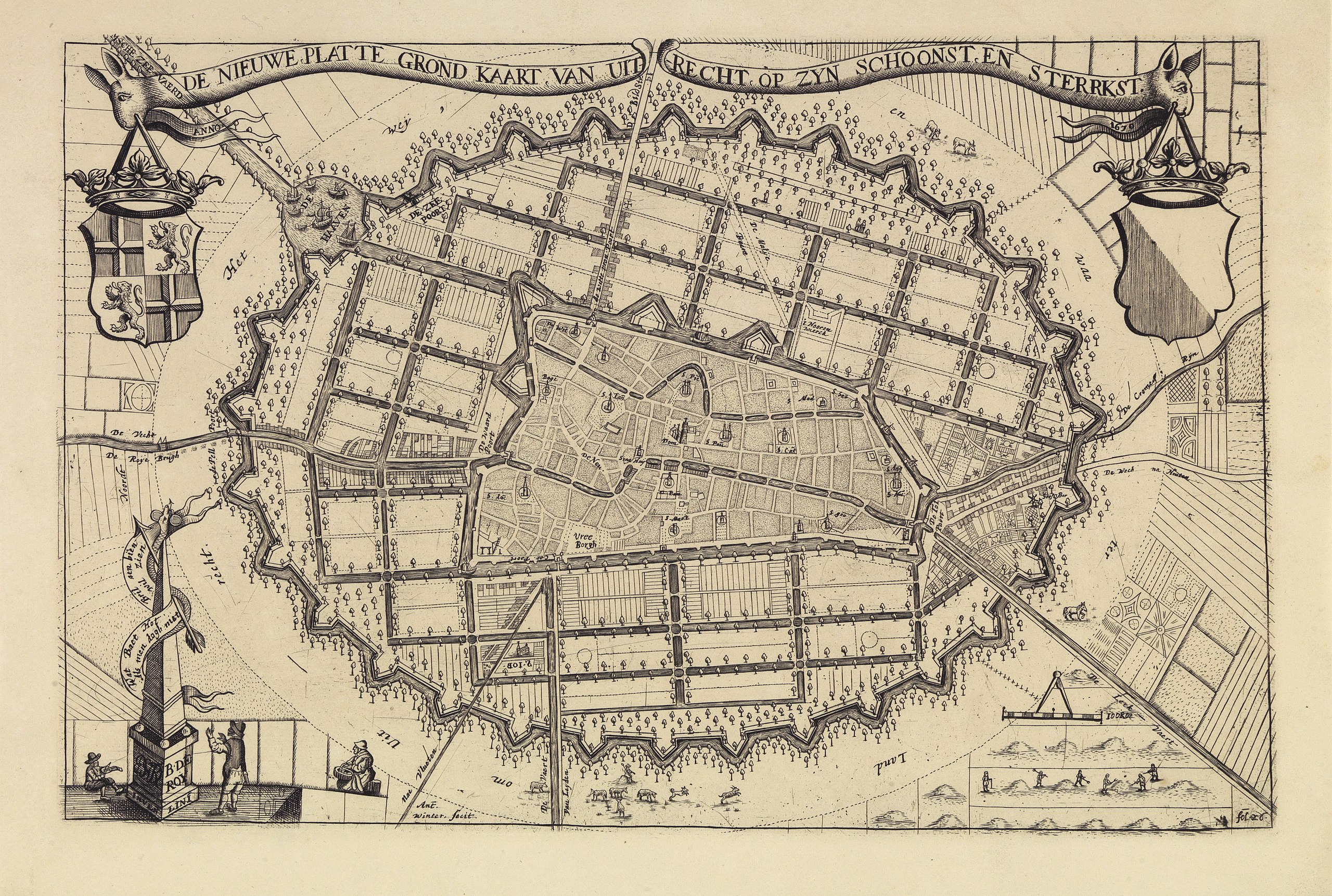
Kaart van het uitbreidingsplan van de stad Utrecht van Everard Meyster; met weergave van de bestaande stad met stratenplan en bebouwing en de ontworpen uitbreiding rond de stad met grachten, wegen, bouwkavels, een nieuwe omwalling en een haven. Linksboven het wapen van provincie Utrecht, rechtsboven het wapen van de stad Utrecht. |
||||||||||||||||||||
| Date | between 1 January 1670 and 31 December 1670 | ||||||||||||||||||||
| Source | https://hetutrechtsarchief.nl/beeld/530A47266AC850A5A16B7B7D68F7A6C3 | ||||||||||||||||||||
| Creator |
Winter, A., graficus; Roij I, B. de, landmeter/cartograaf |
||||||||||||||||||||
| Geotemporal data | |||||||||||||||||||||
| Scale |
Nederlands: 1:12.000 |
||||||||||||||||||||
| Georeferencing | If inappropriate please set warp_status = skip to hide. | ||||||||||||||||||||
| Archival data | |||||||||||||||||||||
| Collection |
|
||||||||||||||||||||
| Accession number |
GUID: 530A47266AC850A5A16B7B7D68F7A6C3, HUA Catalogusnummer: 214182 |
||||||||||||||||||||
| Dimensions | height: 27 cm (10.6 in); width: 41 cm (16.1 in) | ||||||||||||||||||||
| Medium |
Nederlands: kopergravure |
||||||||||||||||||||
| Inscriptions |
Nederlands: " DE NIEUWE PLATTE GROND KAART VAN UIT-RECHT OP ZYN SCHOONST EN STERRKST/ANNO 1670" |
||||||||||||||||||||
| Notes |
Nederlands: Niet-uitgevoerd uitbreidingsplan.<ZR>Een in 1840 gemaakte reproduktie van een 1670 door B. de Roy vervaardigde plattegrond.<ZR>De plattegrond is afkomstig uit: N. van der Monde, Tijdschrift voor geschiedenis, oudheden en statistiek van Utrecht, deel VI, t.o.p. 437.<ZR>Lit. M. Donkersloot-De Vrij, Kaarten van Utrecht, p. 108-110. |
||||||||||||||||||||

Licensing[edit]
|
This work is in the public domain in its country of origin and other countries and areas where the copyright term is the author's life plus 70 years or fewer.
| |
| This file has been identified as being free of known restrictions under copyright law, including all related and neighboring rights. | |
This media file is from the collections of the Het Utrechts Archief. This tag does not indicate the copyright status of the attached work. A normal copyright tag is still required. See Commons:Licensing.
|
File history
Click on a date/time to view the file as it appeared at that time.
| Date/Time | Thumbnail | Dimensions | User | Comment | |
|---|---|---|---|---|---|
| current | 15:46, 15 February 2021 | | 5,956 × 4,008 (7.6 MB) | CompanjeBot (talk | contribs) | Uploading image from Het Utrechts Archief: https://hetutrechtsarchief.nl/beeld/530A47266AC850A5A16B7B7D68F7A6C3 |
You cannot overwrite this file.
File usage on Commons
There are no pages that use this file.