File:Guyana Basemap With disputed areas.png
Jump to navigation
Jump to search

Size of this preview: 457 × 599 pixels. Other resolutions: 183 × 240 pixels | 566 × 742 pixels.
Original file (566 × 742 pixels, file size: 180 KB, MIME type: image/png)
Captions
Captions
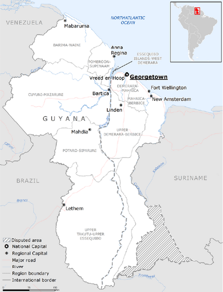
Corrected basemap from Europian union. The disputed areas were left out of the original map.
Summary[edit]
| Description |
English: Corrected basemap from Europian union. The disputed areas were left out of the original map. Guyana has 2 disputed areas. the Entire area west of the Esequibo river is disputed with Venezuela. The area between the Upper-Corantijn and the Coeroeni River is disputed with Suriname (Tigri Area) |
| Date | |
| Source | https://erccportal.jrc.ec.europa.eu/ECHO-Products/Maps#/maps?pageIndex=1&pageSize=200&mt=Base%20map |
| Author | JRC, Europian Union |
Licensing[edit]
This file is licensed under the Creative Commons Attribution-Share Alike 4.0 International license.
- You are free:
- to share – to copy, distribute and transmit the work
- to remix – to adapt the work
- Under the following conditions:
- attribution – You must give appropriate credit, provide a link to the license, and indicate if changes were made. You may do so in any reasonable manner, but not in any way that suggests the licensor endorses you or your use.
- share alike – If you remix, transform, or build upon the material, you must distribute your contributions under the same or compatible license as the original.
File history
Click on a date/time to view the file as it appeared at that time.
| Date/Time | Thumbnail | Dimensions | User | Comment | |
|---|---|---|---|---|---|
| current | 22:09, 16 June 2023 | | 566 × 742 (180 KB) | SurinameCentral (talk | contribs) | Uploaded a work by JRC, Europian Union from https://erccportal.jrc.ec.europa.eu/ECHO-Products/Maps#/maps?pageIndex=1&pageSize=200&mt=Base%20map with UploadWizard |
You cannot overwrite this file.
File usage on Commons
There are no pages that use this file.