File:Gulf of Finland ESA378549.jpg

Original file (1,920 × 1,875 pixels, file size: 3.13 MB, MIME type: image/jpeg)
Captions
Captions
Summary[edit]
| Description |
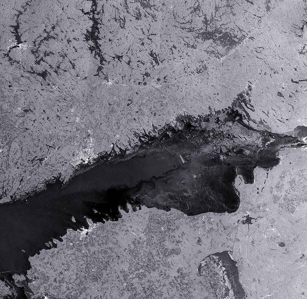
English: The Copernicus Sentinel-1B satellite brings us over the Gulf of Finland, with part of Finland along the top, Estonia along the bottom and Russia to the right.
The gulf is the eastern arm of the Baltic sea, stretching all the way to St Petersburg in Russia. The waters are relatively shallow, with an average depth of 38 m and a maximum of about 100 m. During winter, the waters freeze until late spring. Satellites play an important role during this season for shipping, providing information on ice cover and type that helps icebreaker boats navigate through the frozen waters. On the right side of the image, we can see the lines where icebreakers have created straight routes through the icy waters. In the lower right we can identify another ice-covered body of water: Lake Peipus, straddling the border of Estonia and Russia. Covering over 3550 sq km, it is the largest trans-boundary lake in Europe. Major cities appear as clusters of bright white radar reflections across the image, such as Tallinn in the lower left and Helsinki on the opposite side if the gulf. The Fringe workshop on advances in radar science and applications took place this week in Helsinki. The event brought together scientists who work with data like those provided by Sentinel-1 to detect changes on the ground, such as tectonic activity, the ‘breathing’ of active volcanoes or the movements of buildings. This image, also featured on theEarth from Space video programme, was captured on 8 February 2017. |
| Date | |
| Source | http://www.esa.int/spaceinimages/Images/2017/06/Gulf_of_Finland |
| Author | European Space Agency |
| Permission (Reusing this file) |
contains modified Copernicus Sentinel data (2017), processed by ESA,CC BY-SA 3.0 IGO |
| Other versions |
|
| Title | Gulf of Finland |
| Set | Earth observation image of the week |
| System | Copernicus |
| Mission | Sentinel-1 |
| Location | Estonia |
| Activity | Observing the Earth |
| Keywords | Ice; Icebreaker; Lake; Sea-ice; Shipping routes; Ships; Radar Images |

Licensing[edit]
- You are free:
- to share – to copy, distribute and transmit the work
- to remix – to adapt the work
- Under the following conditions:
- attribution – You must give appropriate credit, provide a link to the license, and indicate if changes were made. You may do so in any reasonable manner, but not in any way that suggests the licensor endorses you or your use.
- share alike – If you remix, transform, or build upon the material, you must distribute your contributions under the same or compatible license as the original.

|
This image contains data from a satellite in the Copernicus Programme, such as Sentinel-1, Sentinel-2 or Sentinel-3. Attribution is required when using this image.
Attribution: Contains modified Copernicus Sentinel data {{{year}}}
The use of Copernicus Sentinel Data is regulated under EU law (Commission Delegated Regulation (EU) No 1159/2013 and Regulation (EU) No 377/2014). Relevant excerpts:
Free access shall be given to GMES dedicated data [...] made available through GMES dissemination platforms [...].
Access to GMES dedicated data [...] shall be given for the purpose of the following use in so far as it is lawful:
GMES dedicated data [...] may be used worldwide without limitations in time.
GMES dedicated data and GMES service information are provided to users without any express or implied warranty, including as regards quality and suitability for any purpose. |
File history
Click on a date/time to view the file as it appeared at that time.
| Date/Time | Thumbnail | Dimensions | User | Comment | |
|---|---|---|---|---|---|
| current | 18:01, 14 June 2017 | | 1,920 × 1,875 (3.13 MB) | Fæ (talk | contribs) | European Space Agency, Id 378549, http://www.esa.int/spaceinimages/Images/2017/06/Gulf_of_Finland, User:Fæ/Project_list/ESA |
You cannot overwrite this file.
File usage on Commons
The following 4 pages use this file:
.jpg&redirect=no)
File usage on other wikis
The following other wikis use this file:
- Usage on bg.wikipedia.org
- Usage on www.wikidata.org