File:Guayana Esequiba (zona completa) incl disputed areas.png
Jump to navigation
Jump to search

Size of this preview: 598 × 600 pixels. Other resolutions: 239 × 240 pixels | 479 × 480 pixels | 784 × 786 pixels.
Original file (784 × 786 pixels, file size: 888 KB, MIME type: image/png)
Captions
Captions
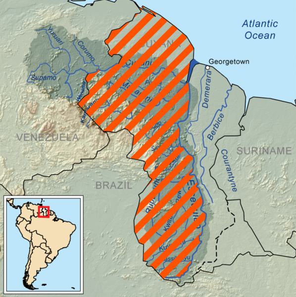
Map of Guyana Essequiba; The area lined in orange constitutes the area disputed between Venezuela and Guyana. This map includes the border dispute between Guyana and Suriname over the Tigri Area.
Summary
[edit]_incl_disputed_areas.png&action=edit§ion=1)
| Description |
English: Map of Guyana Essequiba; The area lined in orange constitutes the area disputed between Venezuela and Guyana. This map includes the border dispute between Guyana and Suriname over the Tigri Area.
Map corrected based on: https://commons.wikimedia.org/wiki/File:Guayana_Esequiba_(zona_completa). |
| Date | |
| Source | Wikimedia Commons |
| Author | Kmusser |
Licensing
[edit]_incl_disputed_areas.png&action=edit§ion=2)
This file is licensed under the Creative Commons Attribution 4.0 International license.
- You are free:
- to share – to copy, distribute and transmit the work
- to remix – to adapt the work
- Under the following conditions:
- attribution – You must give appropriate credit, provide a link to the license, and indicate if changes were made. You may do so in any reasonable manner, but not in any way that suggests the licensor endorses you or your use.
File history
Click on a date/time to view the file as it appeared at that time.
| Date/Time | Thumbnail | Dimensions | User | Comment | |
|---|---|---|---|---|---|
| current | 21:10, 17 December 2023 | | 784 × 786 (888 KB) | SurinameCentral (talk | contribs) | Uploaded a work by Kmusser from Wikimedia Commons with UploadWizard |
You cannot overwrite this file.
File usage on Commons
There are no pages that use this file.
File usage on other wikis
The following other wikis use this file:
- Usage on en.wikipedia.org
_incl_disputed_areas.png&oldid=855659089)