File:Guang Yutu 1588 Vol 2 Pg 102 Grand Canal 3.jpg
Jump to navigation
Jump to search

Size of this preview: 571 × 599 pixels. Other resolutions: 229 × 240 pixels | 458 × 480 pixels | 732 × 768 pixels | 976 × 1,024 pixels | 1,952 × 2,048 pixels | 4,440 × 4,658 pixels.
Original file (4,440 × 4,658 pixels, file size: 3.49 MB, MIME type: image/jpeg)
Captions
Captions
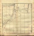
Chinese map of part of the Grand Canal c. 1540
Summary
[edit]| Description |
English: The 3rd "Grand Canal Map" (Caoyun Tu) from Luo Hongxian's Enlarged Atlas, Vol. 2, based on the maps first drafted by Zhu Siben. Library of Congress copy of Hu Song's 1558 revision. Grid of 100×100 li (about 33×33 km or 20×20 mi).
中文:《廣輿圖·第一百零二·漕運圖三》每方百里 |
| Date | |
| Source | LOC |
| Author | Zhu Siben, redrafted and revised by Luo Hongxian, edited by Hu Song |
| Other versions |
|


Licensing
[edit]
|
This work is in the public domain in its country of origin and other countries and areas where the copyright term is the author's life plus 70 years or fewer. This work is in the public domain in the United States because it was published (or registered with the U.S. Copyright Office) before January 1, 1929. | |
| This file has been identified as being free of known restrictions under copyright law, including all related and neighboring rights. | |
| Annotations | This image is annotated: View the annotations at Commons |
File history
Click on a date/time to view the file as it appeared at that time.
| Date/Time | Thumbnail | Dimensions | User | Comment | |
|---|---|---|---|---|---|
| current | 10:14, 4 April 2023 | | 4,440 × 4,658 (3.49 MB) | LlywelynII (talk | contribs) | Uploaded a work by Zhu Siben, redrafted and revised by Luo Hongxian, edited by Hu Song from [https://www.loc.gov/resource/lcnclscd.2008623187.1A002/ LOC] with UploadWizard |
You cannot overwrite this file.
File usage on Commons
The following 7 pages use this file:
- User:Chumwa/OgreBot/Transport Maps/2023 April 1-10
- User:Magog the Ogre/Multilingual legend/2023 April 1-10
- File:Guang Yutu 1588 Vol 2 Pg 101 Grand Canal 2.jpg
- File:Guang Yutu 1588 Vol 2 Pg 103 Grand Canal 4.jpg
- File:Guang Yutu 1588 Vol 2 Pg 104 Grand Canal 5.jpg
- File:Guang yu tu - er juan LOC 2008623187-40.jpg
- File:Guang yu tu - er juan LOC 2008623187-40.tif