File:Grundschule Krötenbruck Hof (Saale) (OSM) Text.svg

Original file (SVG file, nominally 2,663 × 2,325 pixels, file size: 777 KB)
Captions
Captions
Summary
[edit]_(OSM)_Text.svg&action=edit§ion=1)
| Description |
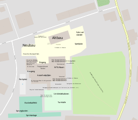
Deutsch: Grundschule Krötenbruck in Hof (Saale) über OpenStreetMap mit Beschreibungen.
English: Street course of Eppenreuther Straße in Hof (Saale) per OpenStreetMap with descriptions. |
| Date | |
| Source | OpenStreetMap / https://www.openstreetmap.org/#map=18/50.29172/11.90314 / geo:50.29172,11.90314?z=18 / Zusätzliche Beschreibungen: Own work / Teilweise Beschreibung: https://www.schule-kroetenbruck.de/schule/lernlandschaft/ |
| Author | Contributors to OSM/Zusätzliche Beschreibungen: PantheraLeo1359531 😺 |
| Other versions | Grundschule Krötenbruck Hof (Saale) (OSM).svg: Blank |
| SVG development |
_(OSM).svg)
BJS = Bundesjugendspiele
Licensing
[edit]_(OSM)_Text.svg&action=edit§ion=2)
| Description |
This map was created from OpenStreetMap project data, collected by the community. This map may be incomplete, and may contain errors. Don't rely solely on it for navigation. |
|||
| Date | (see file history) | |||
| Source | openstreetmap.org | |||
| Creator |
OpenStreetMap contributors |
|||
| Permission (Reusing this file) |
OpenStreetMap data is available under the Open Database License (details). Map tiles are licensed under the Creative Commons Attribution-ShareAlike 2.0 license (CC-BY-SA 2.0).
This file is licensed under the Creative Commons Attribution-Share Alike 2.0 Generic license.
|
|||
| Georeferencing | If inappropriate please set warp_status = skip to hide. |
//Zusätzliche Beschreibungen:
| I, the copyright holder of this work, release this work into the public domain. This applies worldwide. In some countries this may not be legally possible; if so: I grant anyone the right to use this work for any purpose, without any conditions, unless such conditions are required by law. |
File history
Click on a date/time to view the file as it appeared at that time.
| Date/Time | Thumbnail | Dimensions | User | Comment | |
|---|---|---|---|---|---|
| current | 12:15, 19 June 2021 | | 2,663 × 2,325 (777 KB) | PantheraLeo1359531 (talk | contribs) | Anpassungen |
| 12:12, 19 June 2021 |  | 2,663 × 2,325 (776 KB) | PantheraLeo1359531 (talk | contribs) | Anpassungen | |
| 11:27, 19 June 2021 |  | 2,663 × 2,325 (774 KB) | PantheraLeo1359531 (talk | contribs) | Uploaded a work by Contributors to OSM/Zusätzliche Beschreibungen: ~~~ from OpenStreetMap / https://www.openstreetmap.org/#map=18/50.29172/11.90314 / geo:50.29172,11.90314?z=18 / Zusätzliche Beschreibungen: {{own}} with UploadWizard |
You cannot overwrite this file.
File usage on Commons
There are no pages that use this file.
File usage on other wikis
The following other wikis use this file:
- Usage on de.wikipedia.org
_(OSM)_Text.svg&oldid=774163009)