File:Groundwater zone.png
Jump to navigation
Jump to search
No higher resolution available.
Groundwater_zone.png (535 × 303 pixels, file size: 108 KB, MIME type: image/png)
Captions
Captions
Add a one-line explanation of what this file represents
Summary[edit]
| Description |
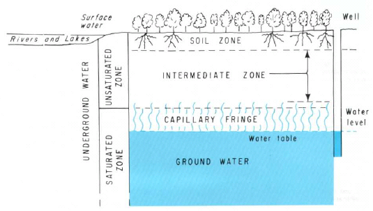
ไทย: น้ำใต้ดินแบ่งออกเป็น 3 โซนได้แก่ soil zone, intermediate zone และ the upper part of capillary fringe |
| Source | https://pubs.er.usgs.gov/ |
| Author | Heath, Ralph C. |
Licensing[edit]
This image is in the public domain in the United States because it only contains materials that originally came from the United States Geological Survey, an agency of the United States Department of the Interior. For more information, see the official USGS copyright policy.
|
File history
Click on a date/time to view the file as it appeared at that time.
| Date/Time | Thumbnail | Dimensions | User | Comment | |
|---|---|---|---|---|---|
| current | 08:50, 22 February 2011 | | 535 × 303 (108 KB) | Tanitha (talk | contribs) | {{Information |Description ={{th|1=น้ำใต้ดินแบ่งออกเป็น 3 โซนได้แก่ soil zone, intermediate zone และ the upper part of capillary fringe}} |Source =http://pubs.er.usgs.gov/ |Author |
You cannot overwrite this file.
File usage on Commons
There are no pages that use this file.
File usage on other wikis
The following other wikis use this file:
- Usage on hr.wikipedia.org
- Usage on sl.wikipedia.org
- Usage on th.wikipedia.org