File:Greenland ice sheet AMSL thickness map-en.svg
Jump to navigation
Jump to search

Size of this PNG preview of this SVG file: 352 × 599 pixels. Other resolutions: 141 × 240 pixels | 282 × 480 pixels | 451 × 768 pixels | 601 × 1,024 pixels | 1,202 × 2,048 pixels | 1,060 × 1,805 pixels.
Original file (SVG file, nominally 1,060 × 1,805 pixels, file size: 2.19 MB)
Captions
Captions
Add a one-line explanation of what this file represents
Summary[edit]
| Description |
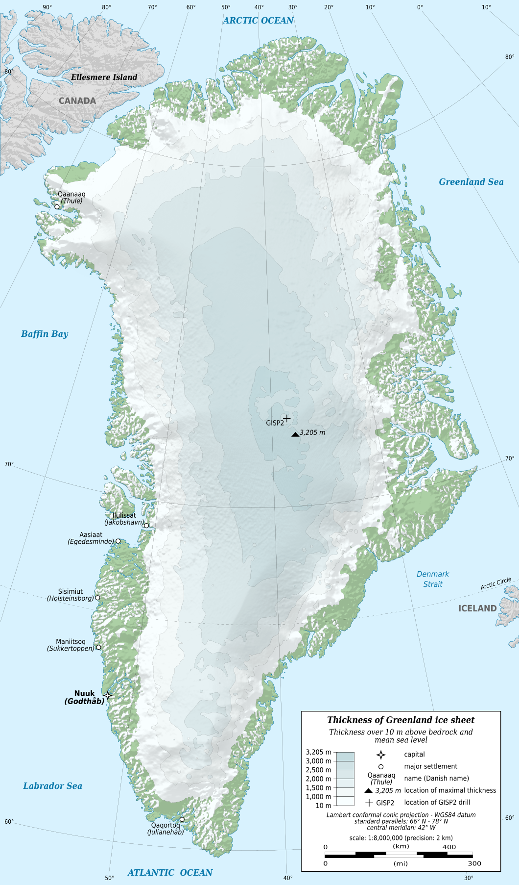
English: Map in English of Greenland ice sheet thickness. Thickness over 10 m above bedrock and mean sea level.
Note: the shaded relief is a raster image embedded in the SVG file. Français : Carte en anglais de l'épaisseur de l'inlandsis du Groenland. Épaisseur supérieure à 10 m au-dessus de la surface rocheuse et du niveau moyen des mers. Note : le relief ombré est une image bitmap embarquée dans le fichier SVG.
|
||
| Date | |||
| Source |
Own work
|
||
| Author | Eric Gaba (Sting - fr:Sting) | ||
| Permission (Reusing this file) |
|
||
| Other versions |
[]
|


| Camera location | | View this and other nearby images on: OpenStreetMap |
|---|

|
This SVG file contains embedded text that can be translated into your language, using any capable SVG editor, text editor or the SVG Translate tool. For more information see: About translating SVG files. |
Licensing[edit]
Eric Gaba (Wikimedia Commons user Sting), the copyright holder of this work, hereby publishes it under the following license:
This file is licensed under the Creative Commons Attribution-Share Alike 3.0 Unported license.
Attribution: Eric Gaba (Wikimedia Commons user Sting)
- You are free:
- to share – to copy, distribute and transmit the work
- to remix – to adapt the work
- Under the following conditions:
- attribution – You must give appropriate credit, provide a link to the license, and indicate if changes were made. You may do so in any reasonable manner, but not in any way that suggests the licensor endorses you or your use.
- share alike – If you remix, transform, or build upon the material, you must distribute your contributions under the same or compatible license as the original.
File history
Click on a date/time to view the file as it appeared at that time.
| Date/Time | Thumbnail | Dimensions | User | Comment | |
|---|---|---|---|---|---|
| current | 21:57, 18 February 2011 | | 1,060 × 1,805 (2.19 MB) | Ras67 (talk | contribs) | black frame removed |
| 18:53, 3 January 2011 |  | 1,060 × 1,805 (2.19 MB) | Sting (talk | contribs) | == {{int:filedesc}} == {{Information |Description={{en|Map in English of Greenland ice sheet thickness. Thickness over 10 m above bedrock and mean sea level.<br/> ''Note: the shaded relief is a raster image embedded in the SVG |
You cannot overwrite this file.
File usage on Commons
The following 10 pages use this file:
- Ice sheets
- File:Greenland Ice.svg
- File:Greenland ice sheet AMSL thickness map-en.png
- File:Greenland ice sheet AMSL thickness map-en.svg
- File:Greenland ice sheet AMSL thickness map-fr.png
- File:Greenland ice sheet AMSL thickness map-ka.svg
- File:Greenland ice sheet AMSL thickness map-mk.svg
- File:Greenland ice sheet AMSL thickness map-pl.svg
- File:Greenland ice sheet thickness map-be.svg
- Template:Other versions/Greenland ice sheet AMSL thickness map
File usage on other wikis
The following other wikis use this file:
- Usage on af.wikipedia.org
- Usage on da.wikipedia.org
- Usage on eu.wikipedia.org
- Usage on fa.wikipedia.org
- Usage on hi.wikipedia.org
- Usage on hr.wikipedia.org
- Usage on hy.wikipedia.org
- Usage on id.wikipedia.org
- Usage on ja.wikipedia.org
- Usage on nl.wikipedia.org
- Usage on nn.wikipedia.org
- Usage on no.wikipedia.org
- Usage on ro.wikipedia.org
- Usage on ru.wikipedia.org
- Usage on sv.wikipedia.org
- Usage on ta.wikipedia.org