File:Goldfinger Tavern, Newburgh Place, Highworth (geograph 2306704).jpg
Jump to navigation
Jump to search

Size of this preview: 800 × 546 pixels. Other resolutions: 320 × 218 pixels | 640 × 437 pixels | 1,024 × 699 pixels.
Original file (1,024 × 699 pixels, file size: 155 KB, MIME type: image/jpeg)
Captions
Captions
Add a one-line explanation of what this file represents
Summary
[edit].jpg&action=edit§ion=1)
| Description |
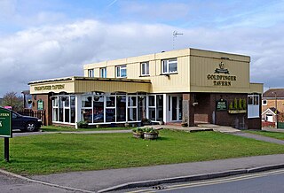
English: Goldfinger Tavern, Newburgh Place, Highworth |
| Date | |
| Source | From geograph.org.uk |
| Author | P L Chadwick |
| Permission (Reusing this file) |
Creative Commons Attribution Share-alike license 2.0 |
| Attribution (required by the license) | P L Chadwick / Goldfinger Tavern, Newburgh Place, Highworth / |
| Camera location | | View this and other nearby images on: OpenStreetMap |
|---|
.jpg¶ms=051.633216_N_-001.715609_E_globe:Earth_type:camera_source:geograph-osgb36(SU19789275)_heading:315.00&language=en)
| Object location | | View this and other nearby images on: OpenStreetMap |
|---|
.jpg¶ms=051.633220_N_-001.715610_E_globe:Earth_class:object_type:object_source:geograph-osgb36(SU19789275)_heading:315.00&language=en)
Licensing
[edit].jpg&action=edit§ion=2)

|
This image was taken from the Geograph project collection. See this photograph's page on the Geograph website for the photographer's contact details. The copyright on this image is owned by P L Chadwick and is licensed for reuse under the Creative Commons Attribution-ShareAlike 2.0 license.
|
This file is licensed under the Creative Commons Attribution-Share Alike 2.0 Generic license.
Attribution: P L Chadwick
- You are free:
- to share – to copy, distribute and transmit the work
- to remix – to adapt the work
- Under the following conditions:
- attribution – You must give appropriate credit, provide a link to the license, and indicate if changes were made. You may do so in any reasonable manner, but not in any way that suggests the licensor endorses you or your use.
- share alike – If you remix, transform, or build upon the material, you must distribute your contributions under the same or compatible license as the original.
File history
Click on a date/time to view the file as it appeared at that time.
| Date/Time | Thumbnail | Dimensions | User | Comment | |
|---|---|---|---|---|---|
| current | 07:19, 7 March 2021 | | 1,024 × 699 (155 KB) | Dumelow (talk | contribs) | Transferred from geograph.co.uk using [https://tools.wmflabs.org/geograph2commons/ geograph2commons] |
You cannot overwrite this file.
File usage on Commons
There are no pages that use this file.
File usage on other wikis
The following other wikis use this file:
- Usage on en.wikipedia.org
- Pub
- Wikipedia:Did you know/Statistics/Monthly DYK pageview leaders/2021
- Flat-roofed pub
- Talk:Flat-roofed pub
- Template:Did you know nominations/Flat-roofed pub
- Wikipedia:Recent additions/2021/April
- Wikipedia:Main Page history/2021 April 5
- Wikipedia:Did you know/Statistics/Monthly DYK pageview leaders/2021/April
- Usage on tum.wikipedia.org
.jpg&oldid=827764502)