File:Goettingen fortifikationsplan matthaeus seutter um 1730.jpg
Jump to navigation
Jump to search

Size of this preview: 701 × 600 pixels. Other resolutions: 281 × 240 pixels | 561 × 480 pixels | 898 × 768 pixels | 1,197 × 1,024 pixels | 1,674 × 1,432 pixels.
Original file (1,674 × 1,432 pixels, file size: 3.31 MB, MIME type: image/jpeg)
Captions
Captions
Add a one-line explanation of what this file represents
Summary[edit]
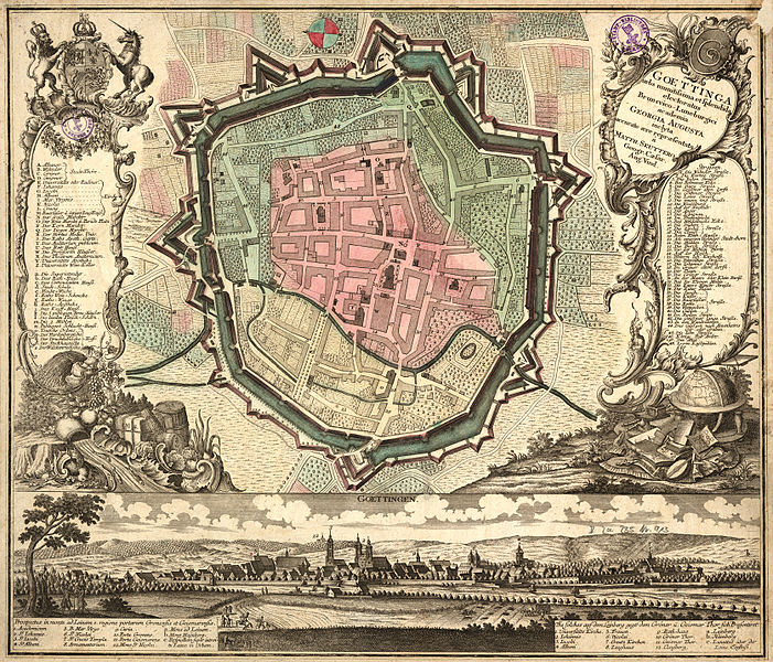
| Description | Goettinga: urbs munitissima et splendida electoratus Brunsvico-Luneburgici academia Georgia Augusta inclyta. Fortifikationsplan der Stadt Göttingen, von Matthäus Seutter (1678-1757), geostet (Osten ist oben, Westen unten) | |||||||||||||||||||||||
| Date | circa 1730 | |||||||||||||||||||||||
| Source | ||||||||||||||||||||||||
| Author |
|
|||||||||||||||||||||||

Licensing[edit]
|
This work is in the public domain in its country of origin and other countries and areas where the copyright term is the author's life plus 100 years or fewer. | |
| This file has been identified as being free of known restrictions under copyright law, including all related and neighboring rights. | |
File history
Click on a date/time to view the file as it appeared at that time.
| Date/Time | Thumbnail | Dimensions | User | Comment | |
|---|---|---|---|---|---|
| current | 12:28, 7 May 2007 | | 1,674 × 1,432 (3.31 MB) | Jonas kork (talk | contribs) | {{Information |Description=Fortifikationsplan der Stadt Göttingen |Source= |Date=um 1730 |Author=Matthäus Seutter |Permission=PD-old |other_versions= }} |
You cannot overwrite this file.
File usage on Commons
The following page uses this file:
File usage on other wikis
The following other wikis use this file:
- Usage on azb.wikipedia.org