File:Gobi Desert (MODIS 2017-08-22).jpg
Jump to navigation
Jump to search

Size of this preview: 800 × 561 pixels. Other resolutions: 320 × 224 pixels | 640 × 449 pixels | 1,024 × 718 pixels | 1,280 × 897 pixels | 2,560 × 1,795 pixels | 5,853 × 4,103 pixels.
Original file (5,853 × 4,103 pixels, file size: 2.92 MB, MIME type: image/jpeg)
Captions
Captions
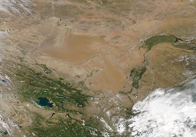
On August 13, 2017, the Moderate Resolution Imaging Spectroradiometer (MODIS) aboard NASA’s Aqua satellite acquired a true-color image of the Gobi Desert.
Summary
[edit].jpg&action=edit§ion=1)
| Description |
English: The Gobi Desert stretches over approximately 500,000 square miles (13 million square km) over China and Mongolia. The name has been translated as “waterless place” or “very large and dry” in Mongolian – and the desert is both vast as well as very arid. The average annual precipitation across the entire desert region is only about 7.6 inches (194 mm), with the heaviest rain falling on the steppes on the edges of the desert. The desert is also a land of extreme temperatures. Known as a “cold” desert, lows of -40°F (-40°C) have been recorded in the dead of winter, while summer temperatures can soar to 40°C (104°F) or more.
On August 13, 2017, the Moderate Resolution Imaging Spectroradiometer (MODIS) aboard NASA’s Aqua satellite acquired a true-color image of the Gobi Desert. Camel-colored sandy regions can be seen near the center of the image. Outside of the sand dunes, the desert is filled with nearly barren rocky outcrops and gravel plains, which appear as various colors of tan. Where precipitation is adequate – mostly outside the Desert - vegetation appears green. This can be seen in the Qilian Mountains in the southwest and in the Yellow River Valley to the southeast. The blue of Qinghai Lake can be seen in the mountains. |
||
| Date | Taken on 13 August 2017 | ||
| Source |
|
||
| Author | Jeff Schmaltz, MODIS Land Rapid Response Team, NASA GSFC |
| This media is a product of the Aqua mission Credit and attribution belongs to the mission team, if not already specified in the "author" row |
Licensing
[edit].jpg&action=edit§ion=2)
| This file is in the public domain in the United States because it was solely created by NASA. NASA copyright policy states that "NASA material is not protected by copyright unless noted". (See Template:PD-USGov, NASA copyright policy page or JPL Image Use Policy.) | ||
 |
Warnings:
|
File history
Click on a date/time to view the file as it appeared at that time.
| Date/Time | Thumbnail | Dimensions | User | Comment | |
|---|---|---|---|---|---|
| current | 17:55, 16 February 2024 | | 5,853 × 4,103 (2.92 MB) | OptimusPrimeBot (talk | contribs) | #Spacemedia - Upload of http://modis.gsfc.nasa.gov/gallery/images/image08222017_250m.jpg via Commons:Spacemedia |
You cannot overwrite this file.
File usage on Commons
There are no pages that use this file.
.jpg&oldid=852747082)