File:Geography of Ecuador within South America.jpg
Jump to navigation
Jump to search

Size of this preview: 800 × 470 pixels. Other resolutions: 320 × 188 pixels | 640 × 376 pixels | 1,159 × 681 pixels.
Original file (1,159 × 681 pixels, file size: 304 KB, MIME type: image/jpeg)
Captions
Captions
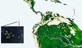
Maps of Galápagos and Ecuador, within South America
Summary
[edit]
| Description |
English: Ecuador is comprised of the Insular Region, Costa Region, Sierra Andina Region, and Oriente Amazónico Region; the reliefs illustrate how the continental geographical regions are interconnected, with the Amazon Basin.
Español: El Ecuador está formado por La Región Insular, Región Costa, Región Sierra Andina, y Región Oriente Amazónico, los relieves muestran como están relacionadas las regiones geográficas continentales, con la cuenca Amazónica. |
| Date | |
| Source | Fusionando https://earthobservatory.nasa.gov/images/7705/leaf-area-index-south-america con https://earthobservatory.nasa.gov/images/2324/galapagos-islands |
| Author | Berposen |
Licensing
[edit]
| This file is in the public domain in the United States because it was solely created by NASA. NASA copyright policy states that "NASA material is not protected by copyright unless noted". (See Template:PD-USGov, NASA copyright policy page or JPL Image Use Policy.) | ||
 |
Warnings:
|
File history
Click on a date/time to view the file as it appeared at that time.
| Date/Time | Thumbnail | Dimensions | User | Comment | |
|---|---|---|---|---|---|
| current | 06:45, 17 November 2023 | | 1,159 × 681 (304 KB) | Berposen (talk | contribs) | Uploaded a work by Berposen from Fusionando https://earthobservatory.nasa.gov/images/7705/leaf-area-index-south-america con https://earthobservatory.nasa.gov/images/2324/galapagos-islands with UploadWizard |
You cannot overwrite this file.
File usage on Commons
There are no pages that use this file.
File usage on other wikis
The following other wikis use this file:
- Usage on es.wikipedia.org