File:Geographic Map of the Captaincy of Mato Grosso WDL910.png
Jump to navigation
Jump to search

Size of this preview: 698 × 600 pixels. Other resolutions: 279 × 240 pixels | 559 × 480 pixels | 894 × 768 pixels | 1,192 × 1,024 pixels.
Original file (1,192 × 1,024 pixels, file size: 2.49 MB, MIME type: image/png)
Captions
Captions
Add a one-line explanation of what this file represents
Summary[edit]
| Title |
Русский: Географическая карта капитанства Мату-Гросу
Français : Carte géographique de la Capitainerie du Mato Grosso
English: Geographic Map of the Captaincy of Mato Grosso
中文:船长马托·格罗索的地形图
Português: Mapa Geográfico da Capitania de Mato Grosso
العربية: خريطة جغرافية لقبطانية ماتو غروسو
Español: Mapa geográfico de la capitanía de Mato Grosso |
| Description |
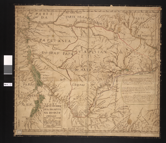
Русский: На этой рукописной карте показаны топографические особенности бразильского штата Мату-Гросу, а также участки Гран-Пара, реки Негро и Сан-Паулу. На ней также изображена провинция Ассумпсон в Парагвае и западные провинции индейцев Моксос и Чикитос. Эти регионы имели особую значимость в войне 1756 года за покорение индейских племенам гуарани — они были в центре территориального спора между португальской и испанской коронами. Важные примечания на правой стороне карты содержат информацию о двух договорах, заключенных двумя королевствами: Мадридском договоре (1750 г.) и Первом договоре в Сан-Ильдефонсо (1777 г.), которые определяли границы территорий, принадлежавших Испании и Португалии в Южной Америке.
Границы; Бразилия -- Границы -- Боливия; Бразилия, Средний Запад; Индейцы Южной Америки Français : Cette carte manuscrite coloriée à la main présente la topographie de l'État brésilien du Mato Grosso, avec des parties de Grão Pará, le fleuve Negro, Goiás, et São Paulo. Elle montre également la province Assumpção du Paraguay ainsi que les provinces occidentales des indiens Moxós et Chiquitos. Ces dernières régions, zones importantes de la guerre des Guaranis de 1756, étaient au centre du conflit territorial entre les couronnes d'Espagne et du Portugal. Des remarques importantes sur le côté droit de la carte fournissent des informations sur les deux traités entre les deux royaumes : le traité de Madrid (1750) et le Premier traité de Santo Ildefonso (1777), définissant l'étendue des possessions respectives de l'Espagne et du Portugal en Amérique du Sud.
Frontières; Brésil -- Frontières -- Bolivie; Brésil, Midwest; Indiens d'Amérique du Sud English: This hand-colored manuscript map shows the topography of the Brazilian state of Mato Grosso, along with parts of Grão Pará, the Negro River, Goiás, and São Paulo. It also shows the Assumpção province of Paraguay and the western provinces of the Moxós and Chiquitos Indians. The latter regions, important areas in the Guarani War of 1756, were at the center of the disputes over territory between the crowns of Spain and Portugal. Important notes on the right side of the map provide information about two treaties between the two kingdoms: the Treaty of Madrid (1750) and the First Treaty of Santo Ildefonso (1777), both of which defined the extent of Spain's and Portugal's respective holdings in South America.
Borders; Brazil -- Borders -- Bolivia; Brazil, Midwest; Indians of South America 中文:这幅手绘彩色地图描绘的是巴西马托格罗索州以及格劳-帕拉省、内格罗河、戈亚斯以及圣保罗的地形地貌。 地图描绘了巴拉圭的 Assumpção 省,以及西部的 Moxós 省和 Chiquitos 印第安省。 后一地区在 1756 年的瓜拉尼战争中作为重要地区,是西班牙和葡萄牙争夺领土归属的中心。 地图右边的重要注释提供了两国间的两个条约:马德里条约(1750 年)以及圣依尔代丰索第一条约(1777 年),这两个条约均定义了西班牙和葡萄牙在南美洲各自所占领的领土。
边界; 巴西-边界-玻利维亚; 巴西中西部; 南美洲印第安人 Português: Esta mapa manuscrito, colorido à mão, mostra a topografia do estado brasileiro de Mato Grosso, juntamente com partes do Grão Pará, o Rio Negro, Goiás e São Paulo. Também mostra a província de Assunção do Paraguai e as províncias ocidentais dos índios Moxós e Chiquitos. Estas últimas regiões, importantes áreas na Guerra dos Guaranis de 1756, eram o centro das disputas territoriais entre as coroas da Espanha e de Portugal. Notas importantes, no lado direito do mapa, fornecem informações sobre dois tratados entre os dois reinos: o Tratado de Madri (1750) e o Primeiro Tratado de Santo Ildefonso (1777), ambos os quais definiram a extensão dos respectivos territórios da Espanha e de Portugal na América do Sul.
Fronteiras; Brasil - Fronteiras - Bolívia; Brasil, Centro-Oeste; Índios da América do Sul العربية: تبين هذه الخريطة المخطوطة الملونة باليد تضاريس ولاية ماتو جروسو في البرازيل، مع أجزاء من غراو بارا، ونهر نيغرو، وغوياس، وساو باولو. وهي تبين كذلك مقاطعة أسامبكاو في باراجواي والمقاطعات الغربية لهنود موكسوس وتشيكيتا. وكانت المناطق التي ورد ذكرها مؤخرًا من المناطق الهامة في حرب غوارانني التي نشبت عام 1756، ومثلت محورًا هاماً للنزاعات حول الأراضي بين التاجين الأسباني والبرتغالي. وتوفر الملاحظات الهامة على الجانب الأيمن من الخريطة معلومات عن معاهدتين تم التوصل إليهما بين المملكتين: معاهدة مدريد (1750)، ومعاهدة سانتو إلديفونسو الأولى ( 1777)، وتحدد كل منهما مدى مقتنيات أسبانيا والبرتغال في أمريكا الجنوبية.
الحدود; البرازيل -- حدود -- بوليفيا; البرازيل، الغرب الأوسط; هنود أمريكا الجنوبية Español: Este mapa manuscrito pintado a mano muestra la topografía del estado brasileño de Mato Grosso, junto con partes de Grão Pará, río Negro, Goiás y São Paulo. También muestra la provincia de Asunción del Paraguay y las provincias occidentales de los indios Chiquitos y Moxos. Estas última regiones, áreas importantes en la Guerra Guaraní de 1756, se encontraban en el centro de las disputas sobre el territorio entre las coronas de España y de Portugal. Notas importantes en el lado derecho del mapa proporcionan información sobre dos tratados entre los dos reinos: el Tratado de Madrid (1750) y el Primer Tratado de San Ildefonso (1777), que definen la extensión de las explotaciones de España y Portugal en América del Sur.
Fronteras; Brasil - Fronteras - Bolivia; Brasil, Oeste Medio; Indios de América del Sur |
| Date | 1800 |
| Medium |
Русский: Карты
Français : Cartes
English: Maps
中文:地图
Português: Mapas
العربية: خرائط
Español: Mapas |
| Dimensions |
English: 1 manuscript map : color ; 62 x 69 centimeters |
| Collection |
Русский: Национальная библиотека Бразилии
Français : Bibliothèque nationale du Brésil
English: National Library of Brazil
中文:巴西国家图书馆
Português: Biblioteca Nacional do Brasil
العربية: مكتبة البرازيل الوطنية
Español: Biblioteca Nacional de Brasil |
| Place of creation |
Русский: Мату-Гросу
Français : Mato Grosso
English: Mato Grosso
中文:马托格罗索
Português: Mato Grosso
العربية: ماتو غروسو
Español: Mato Grosso |
| Notes | Original language title: Carta geografica da capitania do Mato Grosso |
| References | http://hdl.loc.gov/loc.wdl/brrjbn.910 |
| Source/Photographer |
|
Licensing[edit]
|
This is a faithful photographic reproduction of a two-dimensional, public domain work of art. The work of art itself is in the public domain for the following reason:
The official position taken by the Wikimedia Foundation is that "faithful reproductions of two-dimensional public domain works of art are public domain".
This photographic reproduction is therefore also considered to be in the public domain in the United States. In other jurisdictions, re-use of this content may be restricted; see Reuse of PD-Art photographs for details. | ||||
File history
Click on a date/time to view the file as it appeared at that time.
| Date/Time | Thumbnail | Dimensions | User | Comment | |
|---|---|---|---|---|---|
| current | 01:50, 12 March 2014 | | 1,192 × 1,024 (2.49 MB) | Fæ (talk | contribs) | =={{int:filedesc}}== {{Artwork |artist = |author = |title ={{ru|1=Географическая карта капитанства Мату-Гросу}} {{fr|1=Carte géographique de la Capitainerie du Mato Grosso}} {{en|1=Geographic Map of the Captaincy... |
You cannot overwrite this file.
File usage on Commons
The following page uses this file:
File usage on other wikis
The following other wikis use this file:
- Usage on de.wikipedia.org