File:Geocentric vs geodetic latitude with elevation.svg
From Wikimedia Commons, the free media repository
Jump to navigation
Jump to search

Size of this PNG preview of this SVG file: 300 × 275 pixels. Other resolutions: 262 × 240 pixels | 524 × 480 pixels | 838 × 768 pixels | 1,117 × 1,024 pixels | 2,234 × 2,048 pixels.
Original file (SVG file, nominally 300 × 275 pixels, file size: 70 KB)
File information
Structured data
Captions
Captions
Add a one-line explanation of what this file represents
Summary[edit]
| DescriptionGeocentric vs geodetic latitude with elevation.svg |
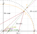
English: Shows how corrections have to be made for height (altitude) when converting from geodetic to geocentric coordinates. Point H is a point on the surface of a spheroid. This point has a geodetic latitude (α) and a geocentric latitude (β). Point H' is a point sharing the same geodetic latitude as point H, but is at a higher altitude and has a different geocentric latitude (γ). |
| Date | |
| Source | Own work. Download source code. |
| Author | SharkD |
| Other versions |
|
This vector image was created with GeoGebra.
Licensing[edit]
| Public domainPublic domainfalsefalse |
| I, the copyright holder of this work, release this work into the public domain. This applies worldwide. In some countries this may not be legally possible; if so: I grant anyone the right to use this work for any purpose, without any conditions, unless such conditions are required by law. |
File history
Click on a date/time to view the file as it appeared at that time.
| Date/Time | Thumbnail | Dimensions | User | Comment | |
|---|---|---|---|---|---|
| current | 15:37, 27 March 2013 |  | 300 × 275 (70 KB) | Citypeek (talk | contribs) | Cleanup of file. Valid SVG now. |
| 23:36, 6 August 2008 |  | 300 × 275 (93 KB) | Datumizer (talk | contribs) | changed style of lines | |
| 23:35, 6 August 2008 |  | 300 × 275 (93 KB) | Datumizer (talk | contribs) | matched color of lines to color of angles | |
| 04:39, 6 August 2008 |  | 300 × 275 (95 KB) | Datumizer (talk | contribs) | image dimensions are now more convenient | |
| 04:33, 6 August 2008 |  | 339 × 311 (95 KB) | Datumizer (talk | contribs) | changed color of one of the angle measurements to purple | |
| 04:31, 6 August 2008 |  | 339 × 311 (95 KB) | Datumizer (talk | contribs) | angle measurements were overlapping | |
| 04:30, 6 August 2008 |  | 339 × 311 (95 KB) | Datumizer (talk | contribs) | Less wasted space, more readable in thumbnail sizes. | |
| 03:00, 8 March 2008 |  | 830 × 633 (59 KB) | Datumizer (talk | contribs) | Angle markers were too hard to distinguish. | |
| 20:15, 16 February 2008 |  | 830 × 633 (61 KB) | Datumizer (talk | contribs) | Image was too small. | |
| 20:00, 16 February 2008 |  | 415 × 316 (61 KB) | Datumizer (talk | contribs) | {{Information |Description=Shows how corrections have to be made for height (altitude) when converting from geodetic to geocentric coordinates. |Source=self-made |Date=2008-02-16 |Author= SharkD |Permission= |other_versions= }} |
You cannot overwrite this file.
File usage on Commons
The following 2 pages use this file:
File usage on other wikis
The following other wikis use this file:
- Usage on ko.wikipedia.org
- Usage on ko.wikiversity.org
- Usage on vi.wikipedia.org
Metadata
This file contains additional information such as Exif metadata which may have been added by the digital camera, scanner, or software program used to create or digitize it. If the file has been modified from its original state, some details such as the timestamp may not fully reflect those of the original file. The timestamp is only as accurate as the clock in the camera, and it may be completely wrong.
| Image title | Creator: FreeHEP Graphics2D Driver Producer: geogebra.b.b Revision: 1.8 Source: Date: Wednesday, August 6, 2008 7:36:21 PM EDT |
|---|---|
| Width | 300 |
| Height | 275 |

