File:Gengub admin.png
Jump to navigation
Jump to search

Size of this preview: 524 × 600 pixels. Other resolutions: 210 × 240 pixels | 419 × 480 pixels | 671 × 768 pixels | 895 × 1,024 pixels | 2,122 × 2,428 pixels.
Original file (2,122 × 2,428 pixels, file size: 1.66 MB, MIME type: image/png)
Captions
Captions
Add a one-line explanation of what this file represents
Summary[edit]
| Description |
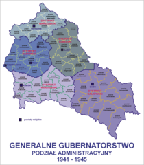
Polski: Generalne Gubernatorstwo - podział administracyjny (1941 -1945) English: Administrative map of the Generalgouvernement (1941 -1945) |
| Date | |
| Source | Own work na bazie: Generalgouvernement fur die besetzten polnischen gebiete |
| Author | Lonio17 |
| Other versions |
 |
Licensing[edit]
I, the copyright holder of this work, hereby publish it under the following licenses:

|
Permission is granted to copy, distribute and/or modify this document under the terms of the GNU Free Documentation License, Version 1.2 or any later version published by the Free Software Foundation; with no Invariant Sections, no Front-Cover Texts, and no Back-Cover Texts. A copy of the license is included in the section entitled GNU Free Documentation License. |
This file is licensed under the Creative Commons Attribution-Share Alike Attribution-Share Alike 4.0 International, 3.0 Unported, 2.5 Generic, 2.0 Generic and 1.0 Generic license.
- You are free:
- to share – to copy, distribute and transmit the work
- to remix – to adapt the work
- Under the following conditions:
- attribution – You must give appropriate credit, provide a link to the license, and indicate if changes were made. You may do so in any reasonable manner, but not in any way that suggests the licensor endorses you or your use.
- share alike – If you remix, transform, or build upon the material, you must distribute your contributions under the same or compatible license as the original.
You may select the license of your choice.
File history
Click on a date/time to view the file as it appeared at that time.
| Date/Time | Thumbnail | Dimensions | User | Comment | |
|---|---|---|---|---|---|
| current | 10:27, 6 October 2021 | | 2,122 × 2,428 (1.66 MB) | Kamilhrub (talk | contribs) | Korekta kształtu powiatów biłgorajskiego, hrubieszowskiego i zamojskiego, w 1941 nie były zmniejszone, a oryginalna granica Galicji nie została zmniejszona, lecz zachowano pas północnej Galicji w dystrykcie lubelskim (na podstawie wykazu gmin GG w 1943). |
| 14:52, 6 March 2021 |  | 2,122 × 2,428 (1.67 MB) | Barry Kent~commonswiki (talk | contribs) | sokolow-wengrow fix | |
| 09:06, 12 May 2009 |  | 2,122 × 2,428 (1.45 MB) | Lonio17 (talk | contribs) | {{Information |Description={{pl|1=Generalne Gubernatorstwo - podział administracyjny (1941 -1945)}} |Source=Praca własna osoby przesyłającej (own work by uploader) na bazie: http://commons.wikimedia.org/wiki/File:Generalgouvernement_fur_die_besetzten |
You cannot overwrite this file.
File usage on Commons
The following 4 pages use this file:
File usage on other wikis
The following other wikis use this file:
- Usage on lt.wikipedia.org
- Usage on pl.wikipedia.org
- Częstochowa
- Generalne Gubernatorstwo
- Kielce
- Lublin
- Radom
- Tomaszów Mazowiecki
- Lwów
- Galicja (Europa Środkowa)
- Dystrykt krakowski
- Landkreis Sanok
- Okupacja niemiecka ziem polskich (1939–1945)
- Dystrykt Galicja
- Landkreis Krosno
- Wikipedysta:Lonio17
- Landkreis Przemysl
- Dystrykt radomski
- Szablon:Dawne powiaty Generalnego Gubernatorstwa
- Landkreis Radom
- Landkreis Kielce
- Landkreis Krakau
- Landkreis Warschau
- Landkreis Drohobycz
- Dystrykt lubelski
- Dystrykt warszawski
- Szablon:Generalne Gubernatorstwo
- Landkreis Debica
- Podział administracyjny Generalnego Gubernatorstwa 1939–1945
- Wikipedysta:Malarz pl/brudnopis/wpss
- Landkreis Busko
- Wikipedysta:Malarz pl/szablony/Państwo infobox
- Landkreis Kamionka Strumiłowa
- Landkreis Rawa Ruska
- Landkreis Lemberg
- Landkreis Stanislau
- Landkreis Stryj
- Landkreis Kolomea
- Landkreis Złoczów
- Landkreis Czortków
- Landkreis Tarnopol
- Landkreis Brzeżany
- Landkreis Jaroslau
- Landkreis Kałusz
- Landkreis Rohatyn
- Landkreis Sambor
- Landkreis Horodenka
- Landkreis Lemberg-Land-Ost
- Landkreis Lemberg-Land-West
- Landkreis Sądowa Wisznia
View more global usage of this file.