File:Gelderland1601-1603 Mauritius de Nassauw 1601.jpg
Jump to navigation
Jump to search

Size of this preview: 737 × 599 pixels. Other resolutions: 295 × 240 pixels | 590 × 480 pixels | 944 × 768 pixels | 1,259 × 1,024 pixels | 2,518 × 2,048 pixels | 4,584 × 3,728 pixels.
Original file (4,584 × 3,728 pixels, file size: 22.61 MB, MIME type: image/jpeg)
Captions
Captions
Add a one-line explanation of what this file represents
Summary
[edit]| Artist |
|
|||||||||||||||||||||||
| Description |
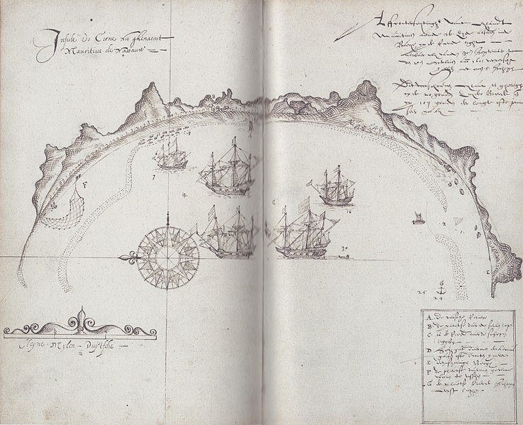
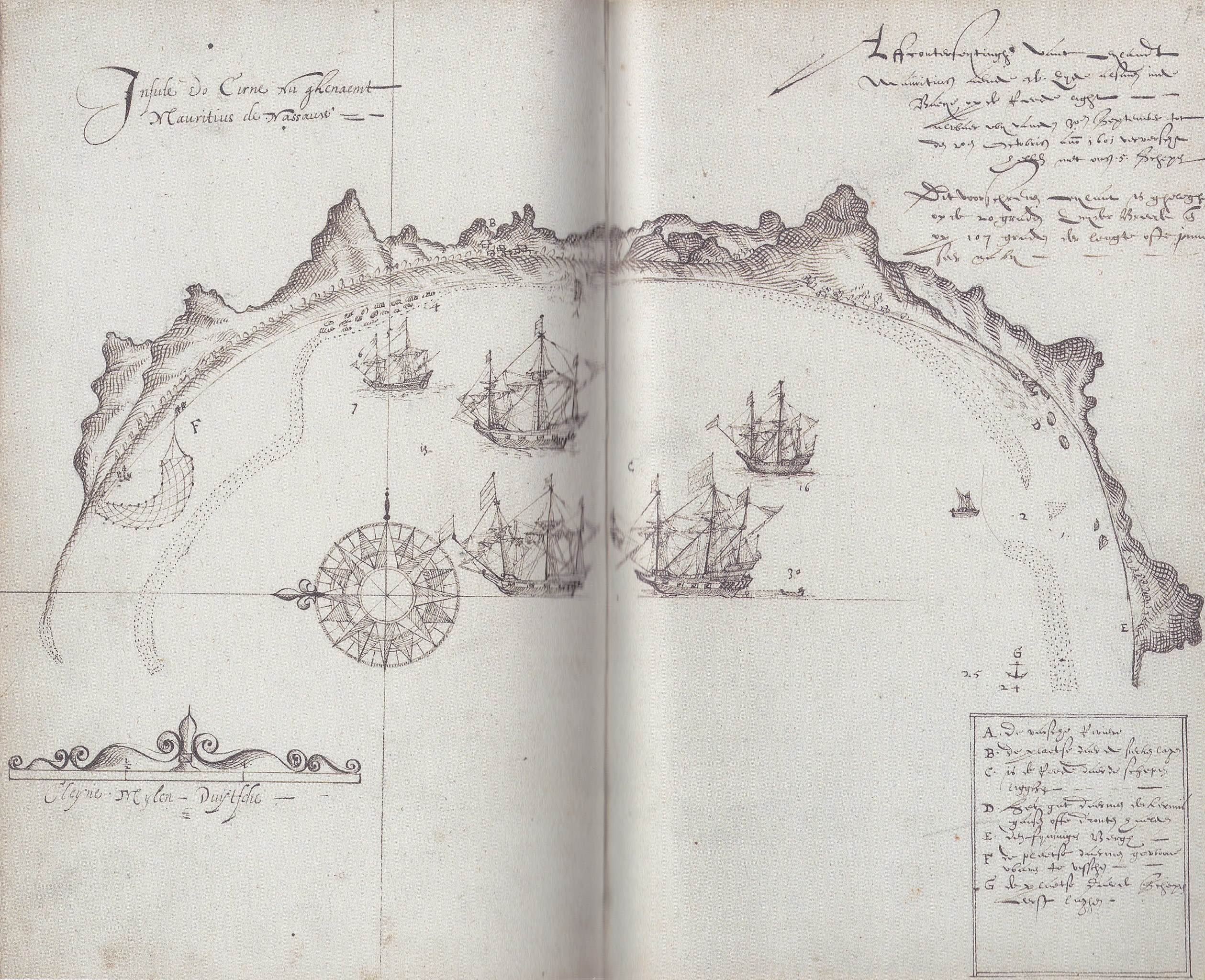
Nederlands: Kaart uit het journaal van het schip De Gelderland. Te zien is een baai in het zuidwesten van Mauritius. In oud-Nederlands staat het volgende erbij geschreven: "Insulde do Cirne nu ghenaemt Mauritius de Nassauw" en "Affconterfeytinghe vant eylant Mauritius aende w. zyde alsmen inde baye opde reede light, alwaer wy vanden 30en september tot den 20en octobris anno 1601 ververscht hebben met onsen 5 schepen. Dit voorschreven eylant is ghelegen op de 20 graden zuyder breedt ende op 107 graden der lengte ofte janner (?) seer naby" en "A. De varsche rivier, B. De plaetse daer de siecken lagen, C. Is de reede daer de schepen ligghen, D. Het gat daermen de Kermisgansen ofte Dronten haelden, E. Den fyninigen bergh, F. De plaetse daermen gewoone waren te visschen, G. De plaetse daer de schepen eerst laghen".
English: Map from the journal of the Dutch ship 'Gelderland'. It shows the bay in the southwest of Mauritius. In old Dutch it says: "Insulde do Cirne nu ghenaemt Mauritius de Nassauw [=Insulde do Cirne now named Mauritius the Nassau]" and "Affconterfeytinghe vant eylant Mauritius aende w. zyde alsmen inde baye opde reede light [= Representation of the island Mauritius at the west side if you lie in the bay's roadsted], alwaer wy vanden 30en september tot den 20en octobris anno 1601 ververscht hebben met onsen 5 schepen [= where we refreshed from 30 September to 20 October 1601 with our 5 ships]. Dit voorschreven eylant is ghelegen op de 20 graden zuyder breedt ende op 107 graden der lengte ofte janner (?) seer naby [= This forementioned island is situated at a latitude of 20 degree South and at 107 degree of longitude of the Janner?? very close by]" and "A. De varsche rivier [= The fresh river], B. De plaetse daer de siecken lagen [= The place where the sick lay], C. Is de reede daer de schepen ligghen [= Is the roadstead where the ships remained], D. Het gat daermen de Kermisgansen ofte Dronten haelden [= The spot where they got the dodo's], E. Den fyninigen bergh [= The fierce mountain], F. De plaetse daermen gewoone waren te visschen [= The place where they usually fished], G. De plaetse daer de schepen eerst laghen [= The place where the ships anchored first]". |
|||||||||||||||||||||||
| Date | 1601 | |||||||||||||||||||||||
| Collection |
|
|||||||||||||||||||||||
| Accession number |
1.04.01, inventory nr 135 |
|||||||||||||||||||||||
| Place of creation | Mauritius | |||||||||||||||||||||||
| Source/Photographer | Nationaal Archief, Den Haag, Archieven van de Compagnieën op Oost-Indië 1.04.01 inventorynumber 135 | |||||||||||||||||||||||

Licensing
[edit]
|
This is a faithful photographic reproduction of a two-dimensional, public domain work of art. The work of art itself is in the public domain for the following reason:
The official position taken by the Wikimedia Foundation is that "faithful reproductions of two-dimensional public domain works of art are public domain".
This photographic reproduction is therefore also considered to be in the public domain in the United States. In other jurisdictions, re-use of this content may be restricted; see Reuse of PD-Art photographs for details. | ||||
This is an image from the Nationaal Archief, the Dutch National Archives, donated in the context of a partnership program. This tag does not indicate the copyright status of the attached work. A normal copyright tag is still required. See Commons:Licensing.
|
File history
Click on a date/time to view the file as it appeared at that time.
| Date/Time | Thumbnail | Dimensions | User | Comment | |
|---|---|---|---|---|---|
| current | 00:06, 10 January 2012 | | 4,584 × 3,728 (22.61 MB) | Pmaas (talk | contribs) |
You cannot overwrite this file.
File usage on Commons
The following 5 pages use this file:
File usage on other wikis
The following other wikis use this file:
- Usage on ar.wikipedia.org
- Usage on bn.wikipedia.org
- Usage on ca.wikipedia.org
- Usage on ceb.wikipedia.org
- Usage on cs.wikipedia.org
- Usage on en.wikipedia.org
- Usage on eu.wikipedia.org
- Usage on it.wikipedia.org
- Usage on pt.wikipedia.org
- Usage on ru.wikipedia.org
- Usage on sv.wikipedia.org