File:Gaza strip 001.gif
Jump to navigation
Jump to search
No higher resolution available.
Gaza_strip_001.gif (329 × 352 pixels, file size: 37 KB, MIME type: image/gif)
Captions
Captions
Add a one-line explanation of what this file represents
| Description |
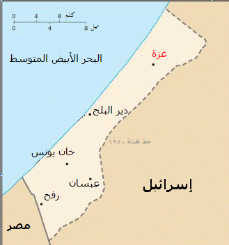
العربية: خارطة للقطاع تبين موقع مدينة غزة
English: This image was copied from en.wikipedia.org. The original description was:
A map of the Gaza Strip showing key towns and neighbouring countries. Taken from CIA World Factbook website on 15 August. Public domain, as is all content from the CIA factbook. |
| Source | File:Gz-map.png |
| Author | |
| Other versions |
 |
Licensing[edit]
This image is in the public domain because it contains materials that originally came from the United States Central Intelligence Agency's World Factbook.
|
 |
Original upload log[edit]
The original description page was here. All following user names refer to ar.wikipedia.
- 2004-05-02 13:38 ירון 329×352× (38097 bytes) ת××× × ×©× ×¨×¦×עת ×¢×× ×¢× ××§×¡× ×¢×¨×× ×ת×ק×
- 2004-04-17 22:15 Ashraf2004 329×352× (38237 bytes) خارطة ÙÙÙطاع تبÙÙ Ù ÙÙع ٠دÙÙØ© غزة
File history
Click on a date/time to view the file as it appeared at that time.
| Date/Time | Thumbnail | Dimensions | User | Comment | |
|---|---|---|---|---|---|
| current | 17:24, 9 January 2009 | | 329 × 352 (37 KB) | File Upload Bot (Magnus Manske) (talk | contribs) | {{BotMoveToCommons|ar.wikipedia}} {{Information |Description={{ar|ترج٠ة ÙصÙرة Øرة. thumb|اÙأص٠٠٠CIA Fact book Ùص٠اÙأص٠This imag |
You cannot overwrite this file.
File usage on Commons
There are no pages that use this file.
File usage on other wikis
The following other wikis use this file:
- Usage on ar.wikipedia.org
- Usage on el.wikinews.org