File:Gaza Strip 2009 Jan 13.png

Original file (1,062 × 1,504 pixels, file size: 369 KB, MIME type: image/png)
Captions
Captions

|
This military map image could be re-created using vector graphics as an SVG file. This has several advantages; see Commons:Media for cleanup for more information. If an SVG form of this image is available, please upload it and afterwards replace this template with
{{vector version available|new image name}}.
It is recommended to name the SVG file “Gaza Strip 2009 Jan 13.svg”—then the template Vector version available (or Vva) does not need the new image name parameter. |
Click the map to enlarge it. To see an even larger version of the map see the first upload of the map to the Commons.
Summary[edit]
| Description |
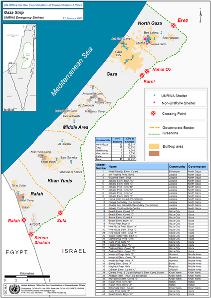
English: Map of the Gaza Strip |
| Date | |
| Source | |
| Author | OCHA oPt (United Nations Office for the Coordination of Humanitarian Affairs - occupied Palestinian territory) |
Licensing[edit]
| This image is a map derived from a United Nations map.
Unless stated otherwise, UN maps are to be considered in the public domain. This applies worldwide. UN maps are, in principle, open source material and you can use them in your work or for making your own map. UN requests however that you delete the UN name, logo and reference number upon any modification to the map. Content of your map will be your responsibility. You can state in your publication, if you wish, something like: based on UN map … (map name, map number, revision number and date). See: Geospatial Information Section. And: Geospatial, location data for a better world. |
 |
File history
Click on a date/time to view the file as it appeared at that time.
| Date/Time | Thumbnail | Dimensions | User | Comment | |
|---|---|---|---|---|---|
| current | 08:41, 15 January 2009 | | 1,062 × 1,504 (369 KB) | Timeshifter (talk | contribs) | More manageable size when people click to see the full-size version. |
| 07:28, 15 January 2009 |  | 1,773 × 2,516 (609 KB) | Timeshifter (talk | contribs) | {{Information |Description={{en|1=Map of the Gaza Strip}} |Source=United Nations |Author=OCHA oPt (United Nations Office for the Coordination of Humanitarian Affairs - occupied Palestinian territory) |Date=Jan. 14, 2009 |Permission= |other_versions= }} {{ |
You cannot overwrite this file.
File usage on Commons
There are no pages that use this file.
File usage on other wikis
The following other wikis use this file:
- Usage on ar.wikipedia.org
- Usage on en.wikipedia.org
- Usage on hu.wikipedia.org
- Usage on it.wikipedia.org