File:Galileo image of Antarctica and Africa.gif
Jump to navigation
Jump to search

Size of this preview: 585 × 600 pixels. Other resolutions: 234 × 240 pixels | 468 × 480 pixels | 702 × 720 pixels.
Original file (702 × 720 pixels, file size: 258 KB, MIME type: image/gif)
Captions
Captions
Add a one-line explanation of what this file represents
Summary[edit]
| Description |
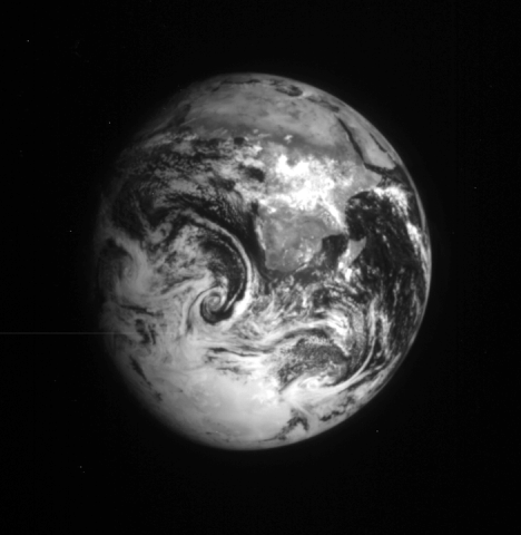
Original caption: " Galileo raw image of Earth taken from 2.7 million km 3 days after the first flyby. Africa and the Middle East can be seen at the top and Antarctica at the bottom. Weather systems are visible in the clouds over the Atlantic and Indian oceans. The image was taken through the infrared (9680 nm) filter, which enhances the visibility of the land masses. Earth is 12,750 km in diameter. (Galileo, 00615203.00) " |
|||||
| Date | ||||||
| Source | NASA | |||||
| Author | Galileo orbiter, NASA/JPL | |||||
| Permission (Reusing this file) |
|

File history
Click on a date/time to view the file as it appeared at that time.
| Date/Time | Thumbnail | Dimensions | User | Comment | |
|---|---|---|---|---|---|
| current | 08:20, 29 April 2011 | | 702 × 720 (258 KB) | Tony Wills (talk | contribs) | {{Information |Description={{Original caption|Galileo raw image of Earth taken from 2.7 million km 3 days after the first flyby. Africa and the Middle East can be seen at the top and Antarctica at the bottom. Weather systems are visible in the clouds over |
You cannot overwrite this file.
File usage on Commons
There are no pages that use this file.
File usage on other wikis
The following other wikis use this file:
- Usage on beta.wikiversity.org
- Usage on en.wikiversity.org