File:GOC Ally Pally 104-110 London from Alexandra Palace (28798288410).jpg

Original file (15,825 × 2,419 pixels, file size: 3.24 MB, MIME type: image/jpeg)
Captions
Captions
Summary[edit]
.jpg&action=edit§ion=1)
| Description |
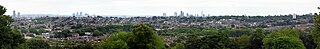
<a href="https://www.flickr.com/photos/anemoneprojectors/28798288410/sizes/o/">View full size here.</a> Panorama of London made from seven photos stitched together, showing the view from Alexandra Palace, Wood Green, Haringey, London N22. Visible here are the O2 Arena (Millennium Dome), Canary Wharf (1 Canada Square, 8 Canada Square, etc), City of London (Tower 42, 30 St Mary Axe, Leadenhall Building, 20 Fenchurch Street, etc), The Shard, the Crystal Palace transmitting tower, Strata, London Eye. The only notable building missing from this shot is the BT Tower. GOC Hertfordshire's walk on 9 July 2016, a 10.2-mile circular walk in London, from Alexandra Palace, visiting Highgate, Finsbury Park, West Green and Wood Green. Andy H led this walk, attended by 15 people. You can view my <a href="https://www.flickr.com/photos/anemoneprojectors/sets/72157672247657155">other photos of this event</a>, read the <a href="http://www.goc.org.uk/groups/reports/hertfordshire/9-july-2016--ally-pally-circular" rel="nofollow">original event report</a>, find out more about the <a href="www.goc.org.uk" rel="nofollow">Gay Outdoor Club</a> or see <a href="https://www.flickr.com/photos/anemoneprojectors/collections/">my collections</a>. |
| Date | |
| Source | GOC Ally Pally 104-110: London from Alexandra Palace |
| Author | Peter O'Connor aka anemoneprojectors |
| Camera location | | View this and other nearby images on: OpenStreetMap |
|---|
.jpg¶ms=051.593463_N_-000.130228_E_globe:Earth_type:camera_source:Flickr_&language=en)
Licensing[edit]
.jpg&action=edit§ion=2)
- You are free:
- to share – to copy, distribute and transmit the work
- to remix – to adapt the work
- Under the following conditions:
- attribution – You must give appropriate credit, provide a link to the license, and indicate if changes were made. You may do so in any reasonable manner, but not in any way that suggests the licensor endorses you or your use.
- share alike – If you remix, transform, or build upon the material, you must distribute your contributions under the same or compatible license as the original.
| This image was originally posted to Flickr by Peter O'Connor aka anemoneprojectors at https://flickr.com/photos/58414938@N00/28798288410. It was reviewed on 11 March 2021 by FlickreviewR 2 and was confirmed to be licensed under the terms of the cc-by-sa-2.0. |
File history
Click on a date/time to view the file as it appeared at that time.
| Date/Time | Thumbnail | Dimensions | User | Comment | |
|---|---|---|---|---|---|
| current | 17:45, 11 March 2021 | 15,825 × 2,419 (3.24 MB) | Matlin (talk | contribs) | Transferred from Flickr via #flickr2commons |
You cannot overwrite this file.
File usage on Commons
There are no pages that use this file.
.jpg&oldid=710233159)