File:Gällivare, Nabreloukta - KMB - 16001000063544.jpg
Gällivare,_Nabreloukta_-_KMB_-_16001000063544.jpg (773 × 531 pixels, file size: 175 KB, MIME type: image/jpeg)
Captions
Captions
| Gällivare, Nabreloukta
( |
|||||||||||||||||||||||||||
|---|---|---|---|---|---|---|---|---|---|---|---|---|---|---|---|---|---|---|---|---|---|---|---|---|---|---|---|
| Photographer |
|
||||||||||||||||||||||||||
| Title |
Gällivare, Nabreloukta |
||||||||||||||||||||||||||
| Original caption |
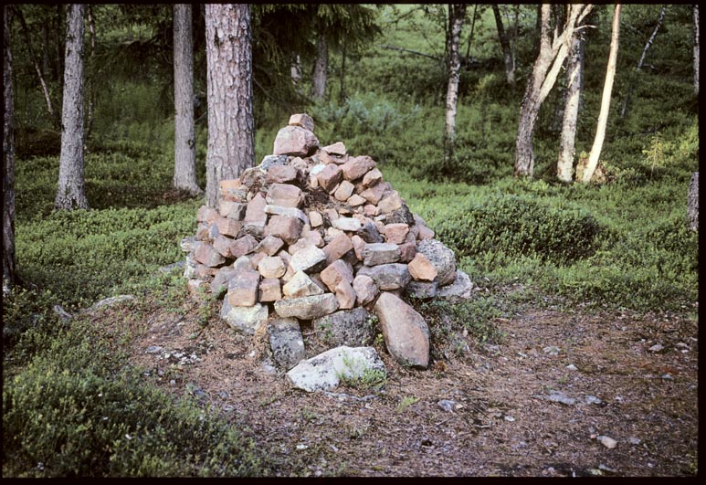
Notera Av dokumentationsskäl har originalbeskrivningen från Riksantikvarieämbetet behållits. Tillrättalägganden och alternativa beskrivningar bör införas separat från nedanstående information. Gällivare 19:1. Nebreloukta. Plats för kapell. På angiven plats skall enligt uppgift, fornminnesinventeringen 1965, Gällivare sockens äldsta kyrka ha uppförts 1650, för att kort efter ha brännts ner. Utgrävd på 1940-talet. Vid besök på platsen vid inventeringstillfälle 1992 iakttogs en stenhög-spismursrest?.Felaktigheter kan även anmälas till denna sida. Motiv: Gällivare 19:1 |
||||||||||||||||||||||||||
| Description |
Gällivare 19:1. Nebreloukta. Plats för kapell. På angiven plats skall enligt uppgift, fornminnesinventeringen 1965, Gällivare sockens äldsta kyrka ha uppförts 1650, för att kort efter ha brännts ner. Utgrävd på 1940-talet. Vid besök på platsen vid inventeringstillfälle 1992 iakttogs en stenhög-spismursrest?. Gällivare 19:1.
|
||||||||||||||||||||||||||
| Depicted place | Sweden, Gällivare Municipality, Gällivare socken | ||||||||||||||||||||||||||
| Date | 1992 | ||||||||||||||||||||||||||
| Collection |
|
||||||||||||||||||||||||||
| Accession number | |||||||||||||||||||||||||||
| Source |
John-Eric Gustafsson / Kulturmiljöbild, Riksantikvarieämbetet
|
||||||||||||||||||||||||||
| Permission (Reusing this file) |
This file is licensed under the Creative Commons Attribution 2.5 Generic license. Attribution: John-Eric Gustafsson / Riksantikvarieämbetet
|
||||||||||||||||||||||||||


| Object location | | View this and other nearby images on: OpenStreetMap |
|---|
File history
Click on a date/time to view the file as it appeared at that time.
| Date/Time | Thumbnail | Dimensions | User | Comment | |
|---|---|---|---|---|---|
| current | 14:43, 11 July 2017 | | 773 × 531 (175 KB) | AndreCostaWMSE-bot (talk | contribs) | {{Kulturmiljöbild-image | short title = Gällivare, Nabreloukta | original description = Gällivare 19:1. Nebreloukta. Plats för kapell. På angiven plats skall enligt uppgift, fornminnesinventeringen 1965, Gällivare sockens äldsta kyrka ha uppför... |
You cannot overwrite this file.
File usage on Commons
The following 2 pages use this file: