File:Friendshiptrail (German text).svg
Jump to navigation
Jump to search

Size of this PNG preview of this SVG file: 512 × 196 pixels. Other resolutions: 320 × 123 pixels | 640 × 245 pixels | 1,024 × 392 pixels | 1,280 × 490 pixels | 2,560 × 980 pixels.
Original file (SVG file, nominally 512 × 196 pixels, file size: 53 KB)
Captions
Captions
Add a one-line explanation of what this file represents
Summary[edit]
.svg&action=edit§ion=1)
| Description |
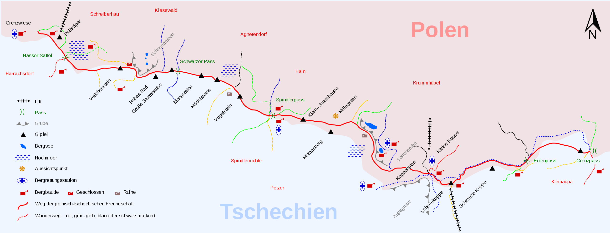
Deutsch: Schematische Karte des Wanderwegs. Die polnischen bzw. tschechischen Namen sind in der Originaldatei hinterlegt und werden beim Überfahren mit der Maus (hover) als Notiz (Tooltip) eingeblendet. English: Schematic map of the trail. The Polish and Czech names are stored in the original file and will be displayed when moving the mouse (hover) as a note (tooltip). Français : Carte schématique du chemin. Les noms polonais et tchèques sont stockés dans le fichier d'origine et seront affichés en déplaçant la souris (hover) comme une note (infobulle). |
| Date | 04.11.15 |
| Source | Own work, based on File:Friendshiptrail1.png |
| Author |
|
| Other versions |
|
| Instructions |
|
| Quality | W3C-validity not checked. |
Licensing[edit]
.svg&action=edit§ion=2)
I, the copyright holder of this work, hereby publish it under the following licenses:

|
Permission is granted to copy, distribute and/or modify this document under the terms of the GNU Free Documentation License, Version 1.2 or any later version published by the Free Software Foundation; with no Invariant Sections, no Front-Cover Texts, and no Back-Cover Texts. A copy of the license is included in the section entitled GNU Free Documentation License. |
This file is licensed under the Creative Commons Attribution-Share Alike Attribution-Share Alike 4.0 International, 3.0 Unported, 2.5 Generic, 2.0 Generic and 1.0 Generic license.
- You are free:
- to share – to copy, distribute and transmit the work
- to remix – to adapt the work
- Under the following conditions:
- attribution – You must give appropriate credit, provide a link to the license, and indicate if changes were made. You may do so in any reasonable manner, but not in any way that suggests the licensor endorses you or your use.
- share alike – If you remix, transform, or build upon the material, you must distribute your contributions under the same or compatible license as the original.
You may select the license of your choice.
File history
Click on a date/time to view the file as it appeared at that time.
| Date/Time | Thumbnail | Dimensions | User | Comment | |
|---|---|---|---|---|---|
| current | 10:15, 8 April 2016 | 512 × 196 (53 KB) | MagentaGreen (talk | contribs) | Weitere Namen hinterlegt | |
| 08:53, 5 April 2016 | 512 × 196 (53 KB) | MagentaGreen (talk | contribs) | Beschriftungs/Zuordnungsfehler korrigiert | ||
| 16:52, 4 April 2016 | 512 × 196 (53 KB) | MagentaGreen (talk | contribs) | polnische und tchechische Namen via Parameter „lang“ | ||
| 14:12, 5 November 2015 | 512 × 196 (67 KB) | MagentaGreen (talk | contribs) | typo | ||
| 13:45, 5 November 2015 | 512 × 196 (67 KB) | MagentaGreen (talk | contribs) | == {{int:filedesc}} == {{Information |Description={{de|1=Schematischer Karte des Wanderwegs}}{{en|1=Schematic map of the trail}}{{fr|1=Carte schématique du chemin}} |Source={{own}}, based on File:Friendshiptrail1.png |Author=*[[User:Kicior99|Kici... |
You cannot overwrite this file.
File usage on Commons
The following 8 pages use this file:
- User:Chumwa/OgreBot/Potential transport maps/2016 April 1-10
- User:Chumwa/OgreBot/Transport Maps/2015 November 1-10
- User:Chumwa/OgreBot/Transport Maps/2016 April 1-10
- User:Chumwa/OgreBot/Travel and communication maps/2016 April 1-10
- File:Friendshiptrail1.png
- File:Friendshiptrail (German text).svg
- File:Friendshiptrail (German text - Czech names).svg
- File:Friendshiptrail (German text - Polish names).svg
.svg)
.svg)
.svg)
File usage on other wikis
The following other wikis use this file:
- Usage on de.wikipedia.org
- Usage on de.wikivoyage.org
.svg&oldid=829401054)