File:Free Territory of Trieste map.png
Jump to navigation
Jump to search

Size of this preview: 379 × 599 pixels. Other resolutions: 152 × 240 pixels | 505 × 798 pixels.
Original file (505 × 798 pixels, file size: 131 KB, MIME type: image/png)
Captions
Captions
Add a one-line explanation of what this file represents
Summary[edit]
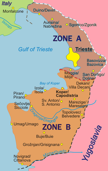
Map of the Free Territory of Trieste (1947-1954), with zone delimitation, in English. Own adaptation of http://sl.wikipedia.org/wiki/Slika:STO.png from the Slovene Wikipedia, by kind permission of the original author.
German version: Image:Freies_Territorium_Triest_Karte.png
Italian version: Image:Territorio_libero_di_Trieste_carta.png
Licensing[edit]
| I, the copyright holder of this work, release this work into the public domain. This applies worldwide. In some countries this may not be legally possible; if so: I grant anyone the right to use this work for any purpose, without any conditions, unless such conditions are required by law. |
File history
Click on a date/time to view the file as it appeared at that time.
| Date/Time | Thumbnail | Dimensions | User | Comment | |
|---|---|---|---|---|---|
| current | 19:34, 21 March 2010 | | 505 × 798 (131 KB) | Ras67 (talk | contribs) | cropped |
| 01:32, 6 October 2007 |  | 511 × 804 (108 KB) | Tomchiukc (talk | contribs) | replace colours of map to distinguish land from the sea. | |
| 16:36, 6 October 2005 |  | 511 × 804 (122 KB) | Alib (talk | contribs) | Map of the Free Territory of Trieste (1947-1954), with zone delimitation, in English. Own adaptation of http://sl.wikipedia.org/wiki/Slika:STO.png from the Slovene Wikipedia, by kind permission of the original author. German version: [[Freies_Territorium_ |
You cannot overwrite this file.
File usage on Commons
There are no pages that use this file.
File usage on other wikis
The following other wikis use this file:
- Usage on fi.wikipedia.org
- Usage on hr.wikipedia.org
- Usage on ja.wikipedia.org
- Usage on nl.wikipedia.org
- Usage on sh.wikipedia.org
- Usage on sv.wikipedia.org
- Usage on tg.wikipedia.org