File:Frederik de Wit, Insula Malta accuratißime Delineata Urbibus et Fortalitiis expressa (FL13730017 2564566).jpg

Original file (10,171 × 8,713 pixels, file size: 119.55 MB, MIME type: image/jpeg)
Captions
Captions
Summary
[edit]| Frederik de Wit: Insula Malta accuratißime Delineata Urbibus et Fortalitiis expressa
( |
||||||||||||||||||||||||
|---|---|---|---|---|---|---|---|---|---|---|---|---|---|---|---|---|---|---|---|---|---|---|---|---|
| Artist |
|
|||||||||||||||||||||||
| Title |
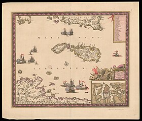
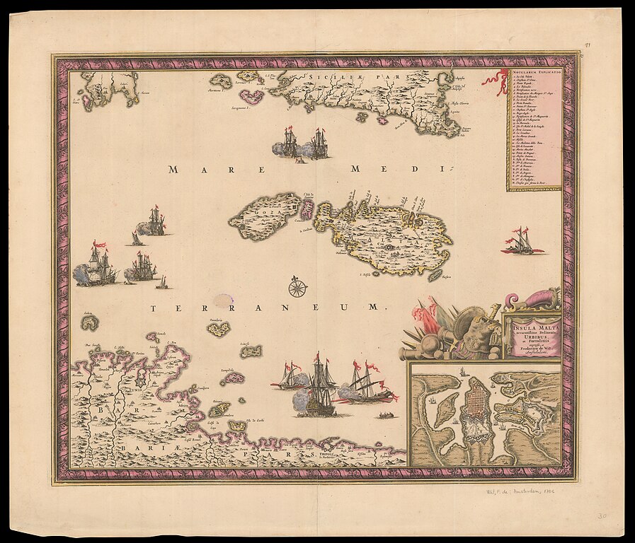
Insula Malta accuratißime Delineata Urbibus et Fortalitiis expressa |
|||||||||||||||||||||||
| Description |
Insula Malta accuratißime Delineata Urbibus et Fortalitiis expressa. a Frederico de Wit.. "A fine map of Malta, with the south coast of Sicily and North Africa including Tunis & Tripoli, with an inset plan of Valletta. It is based on a map by French engineer Sébastien Pontault de Beaulieu, who is regarded as the first military topographer. He drew several maps of Mediterranean islands and their defences during the Ottoman wars, often decorated with a frame-like border like this. The vignette sea battle between a galleon and two galleys highlight the threat from Barbary pirates from Tunis and Tripoli." [1] |
|||||||||||||||||||||||
| Language | Latin | |||||||||||||||||||||||
| Publication date | circa 1680 | |||||||||||||||||||||||
| Medium | 1 sheet : col ; | |||||||||||||||||||||||
| Dimensions | 54 × 63 cm (21.2 × 24.8 in) | |||||||||||||||||||||||
| Collection |
|
|||||||||||||||||||||||
| Current location |
|
|||||||||||||||||||||||
| Place of publication | Amstelaedami | |||||||||||||||||||||||
| search Merhav catalog | Amstelaedami | |||||||||||||||||||||||
| Notes | Bottom right inset, Valetta. Index top right.; Upper right 25 | |||||||||||||||||||||||
| IE PID | IE13730015 | |||||||||||||||||||||||
| Rosetta filename | FL13730017 | |||||||||||||||||||||||
| NNL item ID (P3959) | 990025645660205171 | |||||||||||||||||||||||
| search Merhav catalog | Latin, Frederik de Wit | |||||||||||||||||||||||
| Source/Photographer |
|
|||||||||||||||||||||||
| Other versions | ||||||||||||||||||||||||
| Jpg / Tif version |
|
|||||||||||||||||||||||

.jpg)

.jpg&action=edit§ion=1)
Licensing
[edit].jpg&action=edit§ion=2)
|
This is a faithful photographic reproduction of a two-dimensional, public domain work of art. The work of art itself is in the public domain for the following reason:
The official position taken by the Wikimedia Foundation is that "faithful reproductions of two-dimensional public domain works of art are public domain".
This photographic reproduction is therefore also considered to be in the public domain in the United States. In other jurisdictions, re-use of this content may be restricted; see Reuse of PD-Art photographs for details. | ||||
File history
Click on a date/time to view the file as it appeared at that time.
| Date/Time | Thumbnail | Dimensions | User | Comment | |
|---|---|---|---|---|---|
| current | 12:06, 7 August 2023 | | 10,171 × 8,713 (119.55 MB) | Geagea (talk | contribs) | pattypan 22.03 |
You cannot overwrite this file.
File usage on Commons
The following 2 pages use this file:
.jpg&oldid=819095656)