File:France 40-44.GIF
Jump to navigation
Jump to search

Size of this preview: 709 × 599 pixels. Other resolutions: 284 × 240 pixels | 568 × 480 pixels | 794 × 671 pixels.
Original file (794 × 671 pixels, file size: 50 KB, MIME type: image/gif)
Captions
Captions
Add a one-line explanation of what this file represents
Summary[edit]
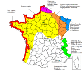
| Description | Map France under German occupation (1940-44) |
| Date | |
| Source | Created by the author, adapted from english version of w:en:User:Adam Carr |
| Author | Emmanuel de Chambost (France) |
| Permission (Reusing this file) |
This adaptation of map of 1940-44 France, created by myself can be used under the GNU Licence EdC, Sept 30th 2006 |
Licensing[edit]
I, the copyright holder of this work, hereby publish it under the following licenses:

|
Permission is granted to copy, distribute and/or modify this document under the terms of the GNU Free Documentation License, Version 1.2 or any later version published by the Free Software Foundation; with no Invariant Sections, no Front-Cover Texts, and no Back-Cover Texts. A copy of the license is included in the section entitled GNU Free Documentation License. |
| This file is licensed under the Creative Commons Attribution-Share Alike 3.0 Unported license. | ||
| ||
| This licensing tag was added to this file as part of the GFDL licensing update. |
You may select the license of your choice.
File history
Click on a date/time to view the file as it appeared at that time.
| Date/Time | Thumbnail | Dimensions | User | Comment | |
|---|---|---|---|---|---|
| current | 20:48, 21 November 2008 | | 794 × 671 (50 KB) | EdC (talk | contribs) | Reverted to version as of 20:43, 21 November 2008 |
| 20:47, 21 November 2008 |  | 794 × 671 (50 KB) | EdC (talk | contribs) | {{Information |Description= |Source= |Date= |Author= |Permission= |other_versions= }} | |
| 20:43, 21 November 2008 |  | 794 × 671 (50 KB) | EdC (talk | contribs) | {{Information |Description= |Source= |Date= |Author= |Permission= |other_versions= }} | |
| 20:40, 21 November 2008 |  | 794 × 671 (50 KB) | EdC (talk | contribs) | Correction of an error in the text | |
| 21:35, 2 November 2008 |  | 794 × 671 (49 KB) | EdC (talk | contribs) | {{Information |Description= Map France under German occupation (1940-44) |Source=Created by the author, adapted from english version of w:en:User:Adam Carr |Date= Sept 30th 2006 modified nov 2nd 2008 |Author=Emmanuel de Chambost (France) |Permission=T | |
| 12:40, 30 September 2006 |  | 743 × 638 (60 KB) | EdC (talk | contribs) |
You cannot overwrite this file.
File usage on Commons
The following page uses this file:
File usage on other wikis
The following other wikis use this file:
- Usage on ca.wikipedia.org
- Usage on de.wikipedia.org
- Usage on es.wikipedia.org
- Usage on ru.wikipedia.org
- Usage on tr.wikipedia.org