File:Forsøkskommuner kommunevalget 2011.svg
Jump to navigation
Jump to search

Size of this PNG preview of this SVG file: 423 × 599 pixels. Other resolutions: 169 × 240 pixels | 339 × 480 pixels | 542 × 768 pixels | 723 × 1,024 pixels | 1,447 × 2,048 pixels | 2,105 × 2,980 pixels.
Original file (SVG file, nominally 2,105 × 2,980 pixels, file size: 1.88 MB)
Captions
Captions
Add a one-line explanation of what this file represents
| Description |
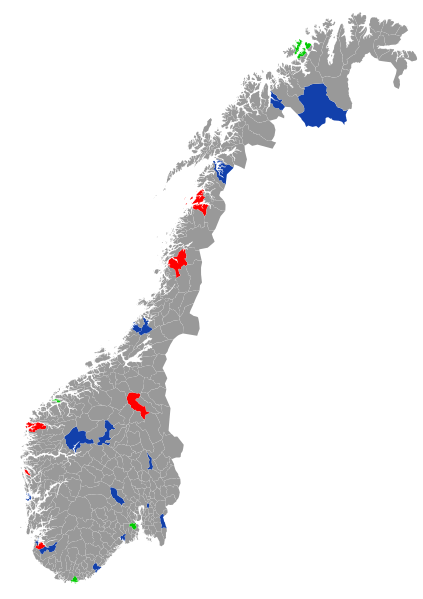
English: A map of the municipalities of Norway taking part of tryouts during the en:Norwegian local elections, 2011. Norsk bokmål: Kart som viser kommunene som deltar i forsøksordningene under kommune og fylkestingsvalget 2011.
Deltar i elektronisk valg
Deltar i stemmerett for 16. åringer
Deltar i begge forsøkene. |
| Date | (UTC) |
| Source |
|
| Author |
|
This file is licensed under the Creative Commons Attribution-Share Alike 2.0 Generic license.
- You are free:
- to share – to copy, distribute and transmit the work
- to remix – to adapt the work
- Under the following conditions:
- attribution – You must give appropriate credit, provide a link to the license, and indicate if changes were made. You may do so in any reasonable manner, but not in any way that suggests the licensor endorses you or your use.
- share alike – If you remix, transform, or build upon the material, you must distribute your contributions under the same or compatible license as the original.
Original upload log
[edit]
This image is a derivative work of the following images:
- File:Norway_municipalities_2010_blank.svg licensed with Cc-by-sa-2.0
- 2011-01-13T15:20:49Z Røed 2105x2980 (1976077 Bytes) La inn fylkesnavn i parantes på kommuner som har samme navn.
- 2011-01-12T00:56:03Z Røed 2105x2980 (1975939 Bytes) Some names missed and rearranged the IDs so that they are sorted by number, also removed some unused code.
- 2011-01-11T22:22:54Z Kåre-Olav 2105x2980 (1988078 Bytes) Added names.
- 2010-03-03T21:55:10Z Kåre-Olav 2105x2980 (1957722 Bytes) {{Information |Description={{en|1=A blank map of the municipalities of Norway (2010). Made with [[w:QGIS|QGIS]] and [[w:Inkscape|Inkscape]] from the following data sources: Coastline from [[w:VMAP0|VMAP0]] (PD). Administrativ
File history
Click on a date/time to view the file as it appeared at that time.
| Date/Time | Thumbnail | Dimensions | User | Comment | |
|---|---|---|---|---|---|
| current | 16:37, 13 January 2011 | | 2,105 × 2,980 (1.88 MB) | Røed (talk | contribs) | {{Information |Description={{en|1=A map of the municipalities of Norway taking part of tryouts during the en:Norwegian local elections, 2011.}} {{no|1=Kart som viser kommunene som deltar i forsøksordningene under kommune og fylkestingsvalget 2011. |
You cannot overwrite this file.
File usage on Commons
There are no pages that use this file.
File usage on other wikis
The following other wikis use this file:
- Usage on nn.wikipedia.org
- Usage on no.wikipedia.org