File:Floods in the Ebro Basin, Spain - detail of the area north of Zaragoza (Copernicus).jpg
Original file (4,454 × 2,540 pixels, file size: 8.44 MB, MIME type: image/jpeg)
Captions
Captions
Summary
[edit].jpg&action=edit§ion=1)
| Description |
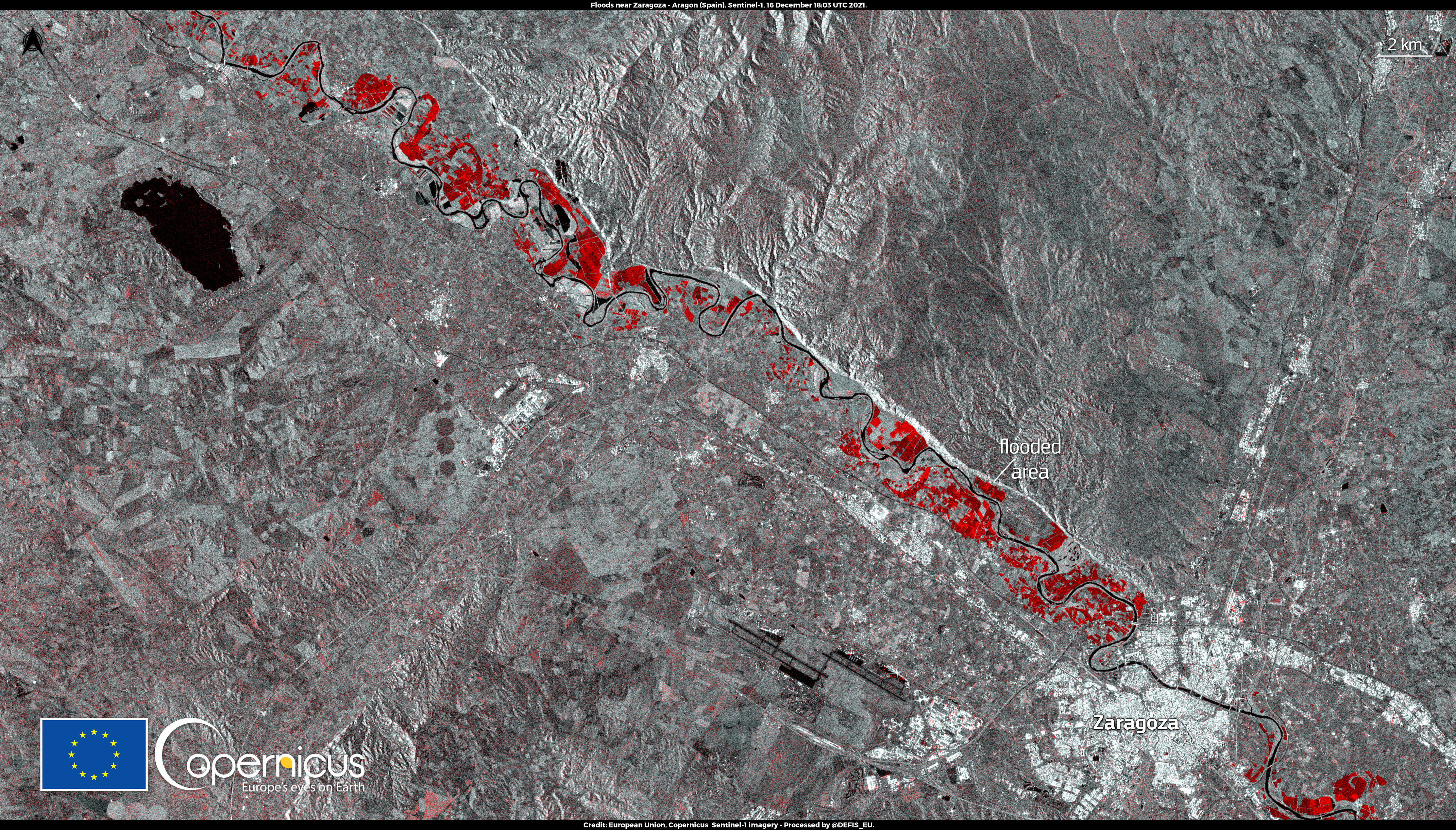
English: In the second weekend of December 2021, Spain was affected by a violent storm that caused heavy floods in parts of Navarra, Aragon, La Rioja, and in the Basque Country. Two casualties have been reported and the damage to crops has been significant. This radar image, acquired by one of the Copernicus Sentinel-1 satellites on 16 December at 18:03 UTC, shows flooded areas north of Zaragoza. According to the Copernicus Emergency Management Service, on the day this image was acquired the flooded areas detected in satellite imagery amounted to more than 11,000 ha. |
| Date | Taken on 16 December 2021 |
| Source | Floods in the Ebro Basin, Spain - detail of the area north of Zaragoza |
| Author | European Union, Copernicus Sentinel-2 imagery |
Licensing
[edit].jpg&action=edit§ion=2)

|
This image contains data from a satellite in the Copernicus Programme, such as Sentinel-1, Sentinel-2 or Sentinel-3. Attribution is required when using this image.
Attribution: Contains modified Copernicus Sentinel data 2021
The use of Copernicus Sentinel Data is regulated under EU law (Commission Delegated Regulation (EU) No 1159/2013 and Regulation (EU) No 377/2014). Relevant excerpts:
Free access shall be given to GMES dedicated data [...] made available through GMES dissemination platforms [...].
Access to GMES dedicated data [...] shall be given for the purpose of the following use in so far as it is lawful:
GMES dedicated data [...] may be used worldwide without limitations in time.
GMES dedicated data and GMES service information are provided to users without any express or implied warranty, including as regards quality and suitability for any purpose. |
File history
Click on a date/time to view the file as it appeared at that time.
| Date/Time | Thumbnail | Dimensions | User | Comment | |
|---|---|---|---|---|---|
| current | 20:28, 3 September 2023 | | 4,454 × 2,540 (8.44 MB) | OptimusPrimeBot (talk | contribs) | #Spacemedia - Upload of https://www.copernicus.eu/system/files/2021-12/image_day/20211218_FloodsAragon_north.jpg via Commons:Spacemedia |
You cannot overwrite this file.
File usage on Commons
There are no pages that use this file.
.jpg&oldid=798653769)