File:Flooding over HWY 190. (2146bb50-5ee2-4c7d-8ecb-a9be278677c1).jpg
Jump to navigation
Jump to search

Size of this preview: 800 × 600 pixels. Other resolutions: 320 × 240 pixels | 640 × 480 pixels | 1,024 × 768 pixels.
Original file (1,024 × 768 pixels, file size: 127 KB, MIME type: image/jpeg)
Captions
Captions
Add a one-line explanation of what this file represents

|
The categories of this image need checking. You can do so here.
|
.jpg&action=edit&withJS=MediaWiki:Catcheck.js)
Summary
[edit].jpg&action=edit§ion=1)
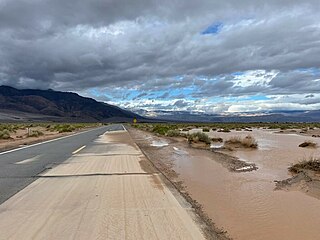
| English: Stovepipe Wells Flooding | ||||
|---|---|---|---|---|
| Photographer |
English: NPS |
|||
| Title |
English: Stovepipe Wells Flooding |
|||
| Description |
English: A long stretch of road flooded with muddy water. Mountains line the valley where the road runs. Flooding over HWY 190.
|
|||
| Depicted place |
English: Death Valley National Park |
|||
| Date | Taken on 21 August 2023 | |||
| Accession number | ||||
| Source |
English: NPGallery |
|||
| Permission (Reusing this file) |
|
|||
| NPS Unit Code | DEVA | |||
| Album(s) | English: Flooding |
|||
File history
Click on a date/time to view the file as it appeared at that time.
| Date/Time | Thumbnail | Dimensions | User | Comment | |
|---|---|---|---|---|---|
| current | 05:09, 25 October 2023 | | 1,024 × 768 (127 KB) | BMacZeroBot (talk | contribs) | Batch upload (Commons:Batch uploading/NPGallery) |
You cannot overwrite this file.
File usage on Commons
The following page uses this file:
.jpg)
.jpg&oldid=815076644)