File:Flooding in Western Europe (MODIS 2021-07-21).jpg

Original file (1,797 × 1,571 pixels, file size: 448 KB, MIME type: image/jpeg)
Captions
Captions
Summary[edit]
.jpg&action=edit§ion=1)
| Description |
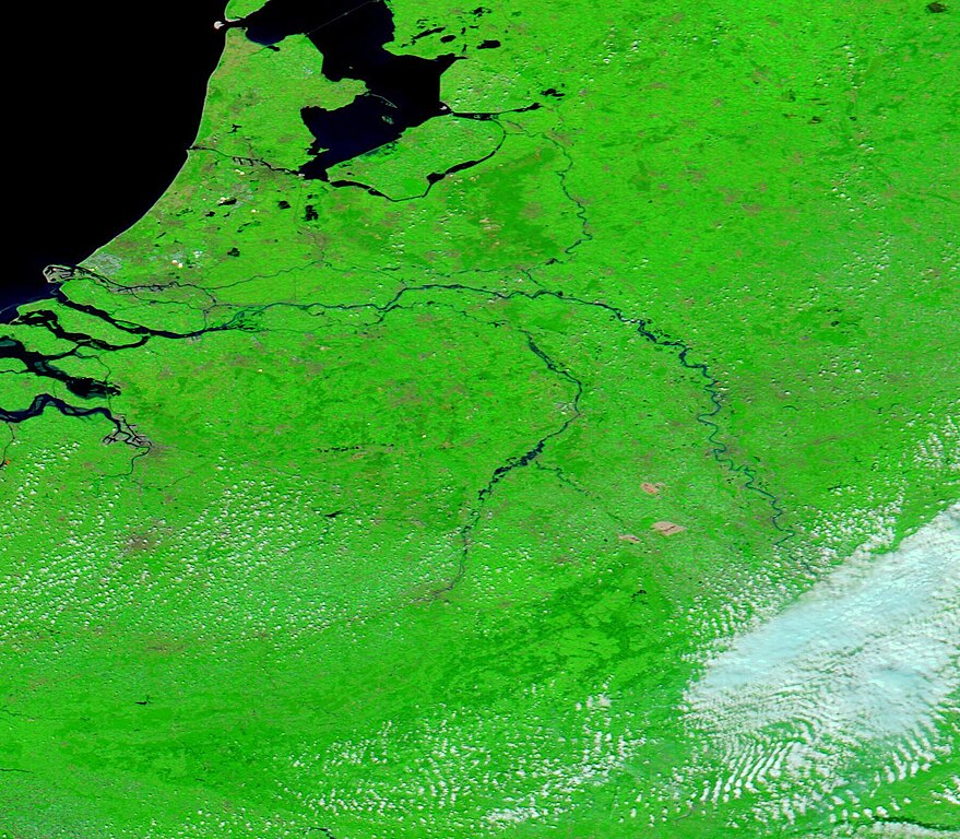
English: Communities in Germany, Belgium, and The Netherlands are reeling after extreme July rainfall swamped parts of Western Europe. Some of the worst-hit areas saw as much as two months of rain within 24 hours—enough to break precipitation records, push rivers to new heights, and trigger devastating flash floods.
Nighttime downpours on July 14-15, 2021, proved especially damaging. Many people were asleep when the most intense rain fell, and they were caught off guard as rivers raged, dams failed, and floodwaters inundated homes. News media estimated that 196 people were killed by flooding and thousands more were injured. Hundreds of people are still listed as missing. On July 17, 2021, the Moderate Resolution Imaging Spectroradiometer (MODIS) on board NASA’s Aqua satellite captured this false-color image of flooding along the Meuse and Roer rivers. This type of image uses infrared and visible light to help separate water from vegetation. Vegetation appears electric green while water appears dark blue. The Meuse and Roer Rivers can be seen colored in dark blue and overflowing their banks, southeast of large Lake Markermeer. While this single image shows substantial flooding, to evaluate the extent of the event it is often helpful to compare images captured by the same instrument in the same area on different days. The NASA Worldview App makes this remarkably easy to do. To view a roll-over comparison between this image collected on July 17 and one collected on June 13 click here. As water levels rose, nearly 5,000 people were forced to evacuate from Roermond, a city in The Netherlands near the border with Germany. The city sits on the lower Roer River at the east bank of the Meuse River. A dam breach on the Roer contributed to the extensive flooding. While it will take some time for experts to analyze whether this event was influenced by human-caused global warming, scientists have amassed data showing that warming has led to more intense and frequent downpours in many parts of the world. Some researchers and meteorologists have also suggested that warming may be changing the jet stream in ways that make atmospheric "blocking" patterns—like the one that prolonged these downpours—more likely. |
||
| Date | Taken on 17 July 2021 | ||
| Source |
Flooding in Western Europe (direct link)
|
||
| Author | MODIS Land Rapid Response Team, NASA GSFC |
| This media is a product of the Aqua mission Credit and attribution belongs to the mission team, if not already specified in the "author" row |
Licensing[edit]
.jpg&action=edit§ion=2)
| This file is in the public domain in the United States because it was solely created by NASA. NASA copyright policy states that "NASA material is not protected by copyright unless noted". (See Template:PD-USGov, NASA copyright policy page or JPL Image Use Policy.) | ||
 |
Warnings:
|
File history
Click on a date/time to view the file as it appeared at that time.
| Date/Time | Thumbnail | Dimensions | User | Comment | |
|---|---|---|---|---|---|
| current | 17:37, 30 January 2024 | | 1,797 × 1,571 (448 KB) | OptimusPrimeBot (talk | contribs) | #Spacemedia - Upload of http://modis.gsfc.nasa.gov/gallery/images/image07212021_250m.jpg via Commons:Spacemedia |
You cannot overwrite this file.
File usage on Commons
There are no pages that use this file.
.jpg&oldid=847255751)