File:Flevoland, the Netherlands (49502353748).jpg

Original file (3,527 × 2,633 pixels, file size: 13.17 MB, MIME type: image/jpeg)
Captions
Captions
Summary
[edit].jpg&action=edit§ion=1)
| Description |
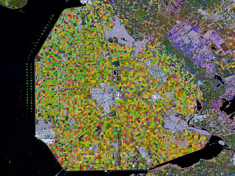
English: The Copernicus Sentinel-1 mission takes us over part of the Dutch province of Flevoland – the newest province in the Netherlands and one of the largest land reclamation projects in the world.
With almost a third of the country lying below sea level, the Netherlands is famously known as a ‘low country,’ and has a long history of land reclamation. One reclamation project resulted in Flevoland. After a major flood it was decided to tame the Zuiderzee, a large, shallow inlet of the North Sea, to improve flood protection and also create additional land for agricultural use. The project entailed the creation of land known as polders. The ‘Noordoostpolder,’ or the Northeast polder is the focus of this image. Over the years, the region has developed to become a home to a modern and innovative agricultural industry. The province produces predominantly apples, cereals, potatoes and flowers – with each colourful patch in the image representing a different crop. This image combines three radar acquisitions from the Copernicus Sentinel-1 mission taken about two months apart to show change in crop and land conditions over time. The first image from 8 May 2018 is associated with red, the second from 7 July depicts changes in green, and the third from 5 September has been linked to blue.
Along the dikes of the Ijsselmeer, west of the Noordoostpolder, lies one of the largest wind farms in the Netherlands. The strong, almost star-shaped, reflections that can be seen near the shore are around 86 wind turbines. The wind farm is said to generate approximately 1.4 billion kWh of clean renewable energy per year – comparable to the power consumption of over 400 000 households. Images acquired with radar are interpreted by studying the intensity of the backscatter radar signal, which is related to the roughness of the ground. Cities and towns are visible in white owing to the stronger reflection of the signal. Emmeloord can be seen in the centre of the Noordoostpolder, as well as several farms that appear as bright white dots along the roads. This image is also featured on the Earth from Space video programme. Credits: contains modified Copernicus Sentinel data (2018), processed by ESA; CC BY-SA 3.0 IGO |
| Date | Taken on 13 March 2019, 16:21:07 |
| Source | Flevoland, the Netherlands |
| Author | europeanspaceagency |
| Flickr set | Earth from Space |
| Flickr tags | flevoland; spacetechnology; observingtheearth; europeanspaceagency; qualityhigh; polders; earthfromspace; space; spacescience; ccon; emmeloord; northsea; satelliteimage; tech; sentinel; sentinel1; copernicus; netherlands; zuiderzee; earthobservation; ijsselmeer; cosmos; technology; esa; radar; universe; science; noordoostpolder; earthexplorer; windfarms |
| Object location | | View this and other nearby images on: OpenStreetMap |
|---|
.jpg¶ms=052.708427_N_0005.769538_E_globe:Earth_class:object_type:object__&language=en)
Licensing
[edit].jpg&action=edit§ion=2)

|
This image contains data from a satellite in the Copernicus Programme, such as Sentinel-1, Sentinel-2 or Sentinel-3. Attribution is required when using this image.
Attribution: Contains modified Copernicus Sentinel data 2018
The use of Copernicus Sentinel Data is regulated under EU law (Commission Delegated Regulation (EU) No 1159/2013 and Regulation (EU) No 377/2014). Relevant excerpts:
Free access shall be given to GMES dedicated data [...] made available through GMES dissemination platforms [...].
Access to GMES dedicated data [...] shall be given for the purpose of the following use in so far as it is lawful:
GMES dedicated data [...] may be used worldwide without limitations in time.
GMES dedicated data and GMES service information are provided to users without any express or implied warranty, including as regards quality and suitability for any purpose. |
- You are free:
- to share – to copy, distribute and transmit the work
- to remix – to adapt the work
- Under the following conditions:
- attribution – You must give appropriate credit, provide a link to the license, and indicate if changes were made. You may do so in any reasonable manner, but not in any way that suggests the licensor endorses you or your use.
- share alike – If you remix, transform, or build upon the material, you must distribute your contributions under the same or compatible license as the original.
| This image was originally posted to Flickr by europeanspaceagency at https://flickr.com/photos/37472264@N04/49502353748. It was reviewed on 26 July 2023 by FlickreviewR 2 and was confirmed to be licensed under the terms of the cc-by-sa-2.0. |
File history
Click on a date/time to view the file as it appeared at that time.
| Date/Time | Thumbnail | Dimensions | User | Comment | |
|---|---|---|---|---|---|
| current | 21:26, 26 July 2023 | | 3,527 × 2,633 (13.17 MB) | OptimusPrimeBot (talk | contribs) | #Spacemedia - Upload of https://live.staticflickr.com/65535/49502353748_dac610cbd4_o.jpg via Commons:Spacemedia |
You cannot overwrite this file.
File usage on Commons
There are no pages that use this file.
.jpg&oldid=797515949)