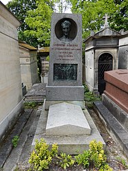
File:Fleury - Le Père Lachaise historique - 135 - Börne.jpg

Original file (835 × 1,291 pixels, file size: 1.08 MB, MIME type: image/jpeg)
Captions
Captions
Contents
Summary
Object
| David d'Angers: Grave of Börne
|
|||||||||||||||||||||||||||
|---|---|---|---|---|---|---|---|---|---|---|---|---|---|---|---|---|---|---|---|---|---|---|---|---|---|---|---|
| Artist |
|
||||||||||||||||||||||||||
| Title |
Grave of Börne label QS:Len,"Grave of Börne"
label QS:Ltr,"Börne Mezarı" |
||||||||||||||||||||||||||
| Object type |
grave |
||||||||||||||||||||||||||
| Genre |
funerary art |
||||||||||||||||||||||||||
| Medium |
bronze |
||||||||||||||||||||||||||
| Dimensions |
height: 40 cm (15.7 in) dimensions QS:P2048,+40U174728 dimensions QS:P2049,+60U174728 |
||||||||||||||||||||||||||
| Collection |
institution QS:P195,Q311
|
||||||||||||||||||||||||||
| Current location | |||||||||||||||||||||||||||
| Object location |
|
||||||||||||||||||||||||||
Photograph
| DescriptionFleury - Le Père Lachaise historique - 135 - Börne.jpg |
Français : Carte postale ancienne - Le Père-Lachaise historique (19e Don) - 135 - Ludwig Boerne, poète allemand. Bas-relief et médaillon de David d'Angers. |
||||||||||||||||
| Date | turn of the 19/20th century | ||||||||||||||||
| Source | Delcampe | ||||||||||||||||
| Author |
creator QS:P170,Q29579172 |
||||||||||||||||
| Object location | 48° 51′ 33.07″ N, 2° 23′ 42.99″ E | View this and other nearby images on: OpenStreetMap |
|---|
Licensing
| Public domainPublic domainfalsefalse |
|
This work is in the public domain in its country of origin and other countries and areas where the copyright term is the author's life plus 70 years or fewer. This work is in the public domain in the United States because it was published (or registered with the U.S. Copyright Office) before January 1, 1929. | |
| This file has been identified as being free of known restrictions under copyright law, including all related and neighboring rights. | |
https://creativecommons.org/publicdomain/mark/1.0/PDMCreative Commons Public Domain Mark 1.0falsefalse
File history
Click on a date/time to view the file as it appeared at that time.
| Date/Time | Thumbnail | Dimensions | User | Comment | |
|---|---|---|---|---|---|
| current | 12:43, 30 May 2017 |  | 835 × 1,291 (1.08 MB) | Pyb (talk | contribs) | Uploaded with LrMediaWiki 0.6.0, LR 6.8 Win |
You cannot overwrite this file.
File usage on Commons
The following 3 pages use this file:
Metadata
This file contains additional information such as Exif metadata which may have been added by the digital camera, scanner, or software program used to create or digitize it. If the file has been modified from its original state, some details such as the timestamp may not fully reflect those of the original file. The timestamp is only as accurate as the clock in the camera, and it may be completely wrong.
| Author | Pierre-Yves Beaudouin |
|---|---|
| Copyright holder |
|
| Online copyright statement | https://creativecommons.org/licenses/by-sa/4.0/ |
| Short title |
|
| City shown | Paris |
| Horizontal resolution | 609 dpi |
| Vertical resolution | 609 dpi |
| Software used | Adobe Photoshop Lightroom 6.8 (Windows) |
| File change date and time | 14:43, 30 May 2017 |
| Exif version | 2.3 |
| Color space | sRGB |
| Unique ID of original document | BEC1EAC20F786974EBE5E8A71FE42F9E |
| Copyright status | Copyrighted |
| Date metadata was last modified | 16:43, 30 May 2017 |
| Code for country shown | FR |
| Sublocation of city shown | Cimetière du Père-Lachaise |
| Country shown | France |
| Province or state shown | Île-de-France |
| IIM version | 4 |


