File:Fires in West Africa (MODIS 2021-12-27).jpg
Jump to navigation
Jump to search

Size of this preview: 800 × 567 pixels. Other resolutions: 320 × 227 pixels | 640 × 453 pixels | 1,024 × 725 pixels | 1,280 × 906 pixels | 2,560 × 1,813 pixels | 3,855 × 2,730 pixels.
Original file (3,855 × 2,730 pixels, file size: 719 KB, MIME type: image/jpeg)
Captions
Captions
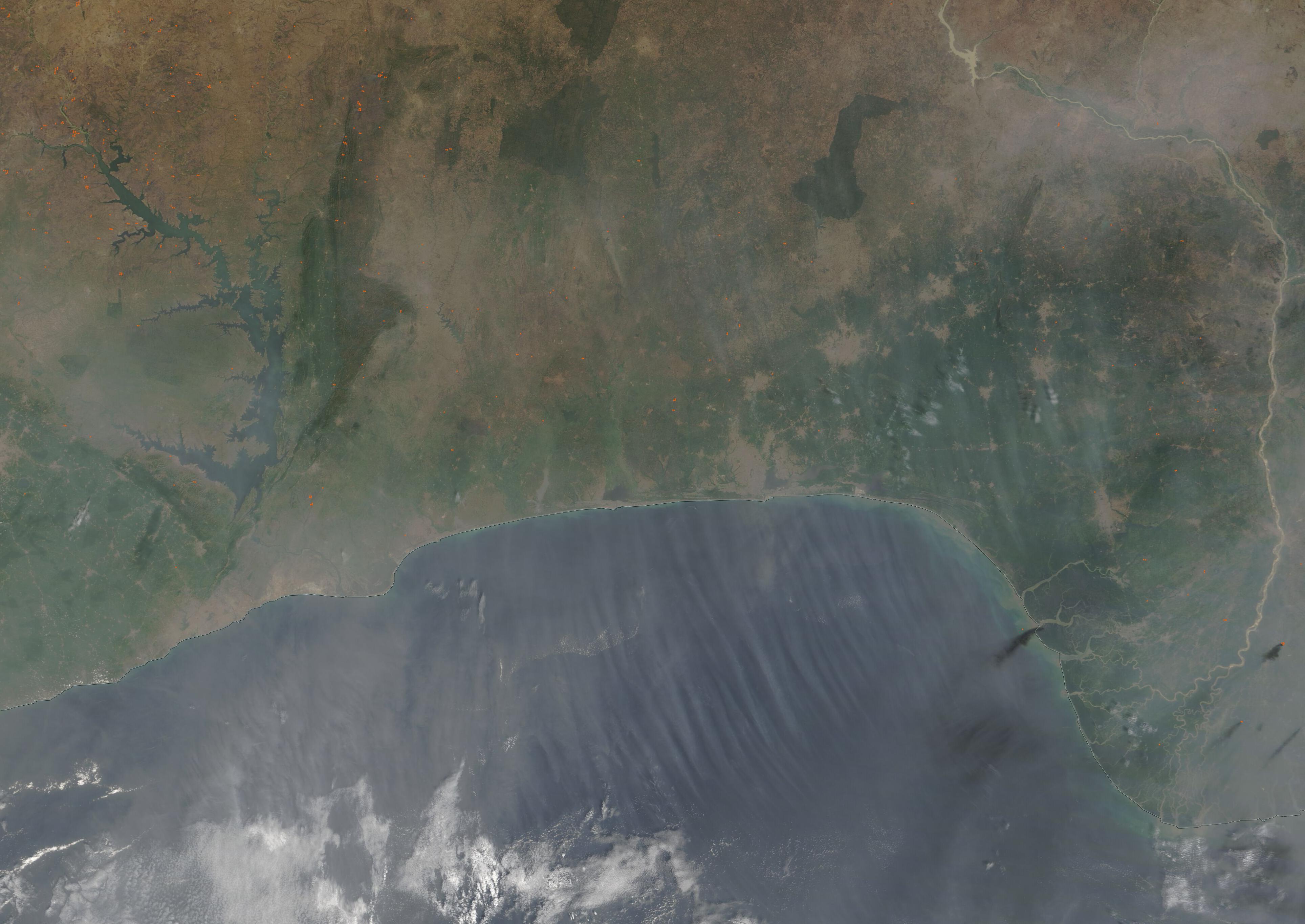
The Moderate Resolution Imaging Spectroradiometer (MODIS) on board NASA’s Terra satellite captured a true-color image of the smoke-filled scene on December 23.
Summary
[edit].jpg&action=edit§ion=1)
| Description |
English: Dozens of fires burned across the southern coast of West Africa in late December 2021. The Moderate Resolution Imaging Spectroradiometer (MODIS) on board NASA’s Terra satellite captured a true-color image of the smoke-filled scene on December 23.
Each red “hot spot” marks an area where the thermal bands on the MODIS instrument detected high temperatures. When combined with typical smoke, as in this image, such hot spots mark actively burning fire. The fires span five countries. From west to east they are Côte d'Ivoire, Ghana, Togo, Benin, and Nigeria. Most are clustered in Côte d'Ivoire and Ghana. Smoke covers the entire region and streamers of smoke pour across the Gulf of Guinea. The location, high number, and time of year strongly suggest that these are agricultural fires, which have been deliberately set to manage crops or pasture. The economy of many of these countries is dominated by agriculture, with high numbers of residents employed as farmers. Fires are used to clear stubble from harvested crops, prepare land for new crops, and to clear new land for pasture or cropping. They are also sometimes ignited to facilitate hunting, by driving game towards the hunters. On a small scale, the fires do not necessarily do serious harm, but large numbers of fire and smoke can cause respiratory problems in people and animals, damage air quality, and may even impact climate. |
||
| Date | Taken on 23 December 2021 | ||
| Source |
Fires in West Africa (direct link)
|
||
| Author | MODIS Land Rapid Response Team, NASA GSFC |
| This media is a product of the Terra mission Credit and attribution belongs to the mission team, if not already specified in the "author" row |
Licensing
[edit].jpg&action=edit§ion=2)
| This file is in the public domain in the United States because it was solely created by NASA. NASA copyright policy states that "NASA material is not protected by copyright unless noted". (See Template:PD-USGov, NASA copyright policy page or JPL Image Use Policy.) | ||
 |
Warnings:
|
File history
Click on a date/time to view the file as it appeared at that time.
| Date/Time | Thumbnail | Dimensions | User | Comment | |
|---|---|---|---|---|---|
| current | 00:19, 17 January 2024 | | 3,855 × 2,730 (719 KB) | OptimusPrimeBot (talk | contribs) | #Spacemedia - Upload of http://modis.gsfc.nasa.gov/gallery/images/image12272021_250m.jpg via Commons:Spacemedia |
You cannot overwrite this file.
File usage on Commons
There are no pages that use this file.
.jpg&oldid=842552847)