File:Fires and Poor Air Quality in West Africa (MODIS 2020-01-23).jpg
Jump to navigation
Jump to search

Size of this preview: 772 × 600 pixels. Other resolutions: 309 × 240 pixels | 618 × 480 pixels | 989 × 768 pixels | 1,280 × 994 pixels | 2,560 × 1,988 pixels | 7,857 × 6,102 pixels.
Original file (7,857 × 6,102 pixels, file size: 2.9 MB, MIME type: image/jpeg)
Captions
Captions
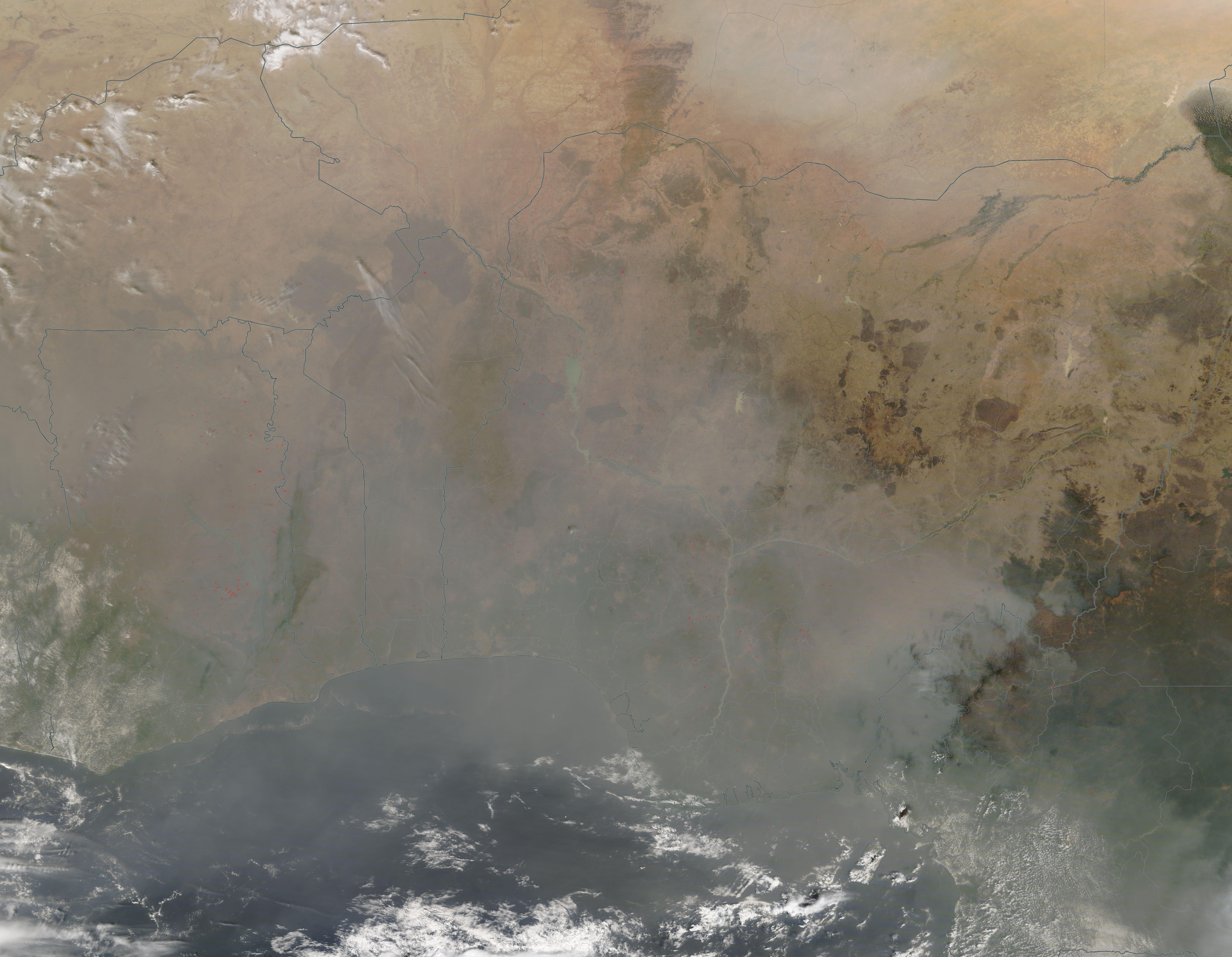
On January 21, 2020, NASA’s Terra satellite passed over West Africa, allowing the Moderate Resolution Imaging Spectroradiometer (MODIS) on board to acquire a true-color image of hundreds of fires burning underneath an expansive shroud of smoke.
Summary
[edit].jpg&action=edit§ion=1)
| Description |
English: On January 21, 2020, NASA’s Terra satellite passed over West Africa, allowing the Moderate Resolution Imaging Spectroradiometer (MODIS) on board to acquire a true-color image of hundreds of fires burning underneath an expansive shroud of smoke.
Fire activity in this region cycles with the season. In the Sahel and savannas just south of the Sahara Desert, the agricultural burning season begins in Northern Hemisphere fall and progresses toward a peak of activity in mid-winter. Each red “hot spot” marks where the thermal bands on the instrument detected increased temperature. When combined with typical smoke, as in this image, such hot spots mark actively burning fire. Fires are burning across the entire region, except for where little vegetation exists. Clusters are especially heavy in Ghana (west), with Nigeria (east), also filled with high numbers of fire. The widespread nature, location, and time of year strongly suggest that these fires have been set to clear or manage land for agricultural purposes. A heavy covering of gray smoke stretches over the entire region, even reaching north to the Sahara. The smoke is so thick over some areas that it obscures the feature of the land beneath. |
||
| Date | Taken on 21 January 2020 | ||
| Source |
Fires and Poor Air Quality in West Africa (direct link)
|
||
| Author | MODIS Land Rapid Response Team, NASA GSFC |
| This media is a product of the Terra mission Credit and attribution belongs to the mission team, if not already specified in the "author" row |
Licensing
[edit].jpg&action=edit§ion=2)
| This file is in the public domain in the United States because it was solely created by NASA. NASA copyright policy states that "NASA material is not protected by copyright unless noted". (See Template:PD-USGov, NASA copyright policy page or JPL Image Use Policy.) | ||
 |
Warnings:
|
File history
Click on a date/time to view the file as it appeared at that time.
| Date/Time | Thumbnail | Dimensions | User | Comment | |
|---|---|---|---|---|---|
| current | 03:21, 17 February 2024 | | 7,857 × 6,102 (2.9 MB) | OptimusPrimeBot (talk | contribs) | #Spacemedia - Upload of http://modis.gsfc.nasa.gov/gallery/images/image01232020_250m.jpg via Commons:Spacemedia |
You cannot overwrite this file.
File usage on Commons
There are no pages that use this file.
.jpg&oldid=852729696)