File:Ferrer 1998 map.jpg
Jump to navigation
Jump to search

Size of this preview: 351 × 599 pixels. Other resolutions: 140 × 240 pixels | 281 × 480 pixels | 913 × 1,559 pixels.
Original file (913 × 1,559 pixels, file size: 165 KB, MIME type: image/jpeg)
Captions
Captions
Add a one-line explanation of what this file represents


Summary
[edit]
| Description |
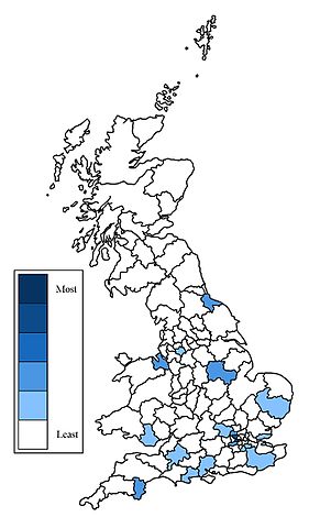
English: Map of Great Britain showing the distribution of the surname Ferrer in 1998. The map is divided into postal areas of the United Kingdom. |
| Date | |
| Source | Own work (Original text: self-made) |
| Author | Celtus (talk) |
Licensing
[edit]
This file is licensed under the Creative Commons Attribution 3.0 Unported license.
- You are free:
- to share – to copy, distribute and transmit the work
- to remix – to adapt the work
- Under the following conditions:
- attribution – You must give appropriate credit, provide a link to the license, and indicate if changes were made. You may do so in any reasonable manner, but not in any way that suggests the licensor endorses you or your use.
{{self|author=Celtus at English Wikipedia
Original upload log
[edit]
The original description page was here. All following user names refer to en.wikipedia.
| Date/Time | Dimensions | User | Comment |
|---|---|---|---|
| 2008-02-29 09:39 | 913×1559× (168520 bytes) | Celtus | {{Information |Description=Distribution map of the surname Ferrer in Great Britain in 1998. The map is divided in UK postal areas. |Source=self-made |Date=February 28, 2008 |Location= |Author=~~~ |other_versions= }} |
File history
Click on a date/time to view the file as it appeared at that time.
| Date/Time | Thumbnail | Dimensions | User | Comment | |
|---|---|---|---|---|---|
| current | 03:42, 9 June 2016 | | 913 × 1,559 (165 KB) | BD2412 (talk | contribs) | Transferred from en.wikipedia |
You cannot overwrite this file.
File usage on Commons
There are no pages that use this file.