File:Feldberger Seen Abflussverteilung 2003–2018.png
Jump to navigation
Jump to search
Size of this preview: 370 × 599 pixels. Other resolutions: 148 × 240 pixels | 296 × 480 pixels | 880 × 1,424 pixels.
Original file (880 × 1,424 pixels, file size: 51 KB, MIME type: image/png)
Captions
Captions
Add a one-line explanation of what this file represents
Summary[edit]
| Description |
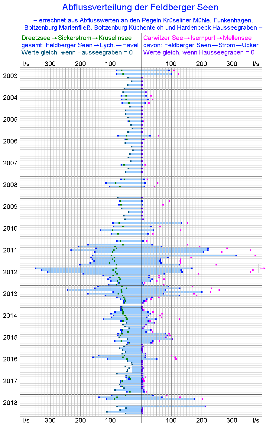
English: Distribution of the water discharge from the Feldberger Seen (group of lakes near Feldberg in the municipality of Feldberger Seenlandschaft) to various waterways and finally the rivers Havel and Ucker/Uecker.
Deutsch: Zugrunde liegende Berechnungen: Die Abflussmenge des Sickerstrom aus dem Dreetzsee zum Krüseliner See ist die Differenz aus den Messwerten an der Krüseliner Mühle und dem Wassereintrag aus dem Oberflächeneinzugsgebiet des Krüseliner Sees. Der ist zu kalkulieren aus dessen Fläche und der gleichzeitigen regionalen Dichte des Niederschlagsüberschusses, diese aus der Abflussdifferenz zwischen den Pegeln Marienfließ und Funkenhagen und der Fläche des dazwischen liegenden Teileinzugsgebietes. Die Verteilung des Abflusses durch die Isernpurt (Pegel Funkenhagen) auf Ucker und Havel ergibt sich aus dem Verhältnis zwischen den beiden Abflüssen aus der Biotzenburger Scheitelhaltung, also den Abflusswerten am Wehr Küchenteich und am Wehr Hardenbeck (Ausgangspunkt des Hausseebruchgrabens). |
| Date | |
| Source | Hydrological data lists of LfU Brandenburg in Potsdam-Groß-Glienecke and StALU Mecklenburgische Seenplatte in Neubrandenburg |
| Author | Ulamm (talk) |
Licensing[edit]
I, the copyright holder of this work, hereby publish it under the following licenses:

|
Permission is granted to copy, distribute and/or modify this document under the terms of the GNU Free Documentation License, Version 1.2 or any later version published by the Free Software Foundation; with no Invariant Sections, no Front-Cover Texts, and no Back-Cover Texts. A copy of the license is included in the section entitled GNU Free Documentation License. |
This file is licensed under the Creative Commons Attribution-Share Alike Attribution-Share Alike 4.0 International, 3.0 Unported, 2.5 Generic, 2.0 Generic and 1.0 Generic license.
- You are free:
- to share – to copy, distribute and transmit the work
- to remix – to adapt the work
- Under the following conditions:
- attribution – You must give appropriate credit, provide a link to the license, and indicate if changes were made. You may do so in any reasonable manner, but not in any way that suggests the licensor endorses you or your use.
- share alike – If you remix, transform, or build upon the material, you must distribute your contributions under the same or compatible license as the original.
You may select the license of your choice.
File history
Click on a date/time to view the file as it appeared at that time.
| Date/Time | Thumbnail | Dimensions | User | Comment | |
|---|---|---|---|---|---|
| current | 07:35, 13 July 2019 | | 880 × 1,424 (51 KB) | Ulamm (talk | contribs) | time of the overshoot value of Isernpurt |
| 06:26, 12 July 2019 |  | 880 × 1,424 (51 KB) | Ulamm (talk | contribs) | visibility improved by bars | |
| 11:37, 9 July 2019 |  | 880 × 1,424 (51 KB) | Ulamm (talk | contribs) | {{Information |Description= {{en|Distribution of the water discharge from the Feldberger Seen (group of lakes near Feldberg in the municipality of Feldberger Seenlandschaft) to various waterways and finally the rivers Havel and Ucker/Uecker.}} {{de|Zugrunde liegende Berechnungen: Die Abflussmenge des Sickerstrom aus dem Dreetzsee zum Krüseliner See ist die Differenz aus den Messwerten an der Krüseliner Mühle und dem Wassereintrag aus dem Oberflächeneinzugsgebiet des Krüseliner Sees. Der ist z... |
You cannot overwrite this file.
File usage on Commons
There are no pages that use this file.
File usage on other wikis
The following other wikis use this file:
- Usage on de.wikipedia.org