File:Faroe Islands ESA21791216.jpeg

Original file (2,412 × 3,015 pixels, file size: 5.15 MB, MIME type: image/jpeg)
Captions
Captions
Summary[edit]
| Description |
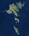
English: The Copernicus Sentinel-2 mission takes us over the Faroe Islands, located halfway between Iceland and Norway in the North Atlantic Ocean. The Faroe Islands are an archipelago made up of 18 jagged islands and are a self-governing nation under the external sovereignty of the Kingdom of Denmark. The archipelago is around 80 km wide and has a total area of approximately 1400 sq km. The official language of the Faroe Islands is Faroese, a Nordic language which derives from the language of the Norsemen who settled the islands over 1000 years ago. The islands have a population of around 50 000 inhabitants – as well as 70 000 sheep. Around 40% of the population reside in the capital and largest city of the Faroe Islands, Tórshavn, visible on the island of Streymoy, slightly above the centre of the image. The islands are a popular destination for birdwatchers, particularly on the island of Mykines, the westernmost island of the Faroese Archipelago. The island provides a breeding and feeding habitat for thousands of birds, including the Atlantic Puffins. Several inland water bodies can be seen dotted around the islands. Lake Sørvágsvatn, the largest lake of the Faroe Islands, is visible at the bottom of Vágar Island to the right of Mykines. Vágar Airport, the only airport in the Faroe Islands, can be seen left of the lake. In this image, captured on 21 June 2018, several clouds can be seen over the Northern Isles, top right of the image. Low vegetation is visible in bright green. The unique landscape of the Faroe Islands was shaped by volcanic activity approximately 50 to 60 million years ago. The original plateau was later restructured by the glaciers of the ice age and the landscape eroded into an archipelago characterised by steep cliffs, deep valleys and narrow fjords. The islands are particularly known for their dramatic landscape, grass-roofed houses and treeless moorlands. The Faroe Islands boast over 1000 km of coastline and because of their elongated shape, one can never be more than five km to the ocean from any point of the islands. This image is also featured on the Earth from Space video programme. |
| Date | Taken on 21 June 2018 |
| Source | Faroe Islands |
| Author | European Space Agency |
| Other versions |
|
| Activity | Observing the Earth |
| Mission | Sentinel-2 |
| Set | Earth observation image of the week |
| System | Copernicus |
Licensing[edit]

|
This image contains data from a satellite in the Copernicus Programme, such as Sentinel-1, Sentinel-2 or Sentinel-3. Attribution is required when using this image.
Attribution: Contains modified Copernicus Sentinel data 2018
The use of Copernicus Sentinel Data is regulated under EU law (Commission Delegated Regulation (EU) No 1159/2013 and Regulation (EU) No 377/2014). Relevant excerpts:
Free access shall be given to GMES dedicated data [...] made available through GMES dissemination platforms [...].
Access to GMES dedicated data [...] shall be given for the purpose of the following use in so far as it is lawful:
GMES dedicated data [...] may be used worldwide without limitations in time.
GMES dedicated data and GMES service information are provided to users without any express or implied warranty, including as regards quality and suitability for any purpose. |
This media was created by the European Space Agency (ESA).
Where expressly so stated, images or videos are covered by the Creative Commons Attribution-ShareAlike 3.0 IGO (CC BY-SA 3.0 IGO) licence, ESA being an Intergovernmental Organisation (IGO), as defined by the CC BY-SA 3.0 IGO licence. The user is allowed under the terms and conditions of the CC BY-SA 3.0 IGO license to Reproduce, Distribute and Publicly Perform the ESA images and videos released under CC BY-SA 3.0 IGO licence and the Adaptations thereof, without further explicit permission being necessary, for as long as the user complies with the conditions and restrictions set forth in the CC BY-SA 3.0 IGO licence, these including that:
See the ESA Creative Commons copyright notice for complete information, and this article for additional details.
|
 | |
This file is licensed under the Creative Commons Attribution-ShareAlike 3.0 IGO license. Attribution: ESA, CC BY-SA IGO 3.0
| ||
File history
Click on a date/time to view the file as it appeared at that time.
| Date/Time | Thumbnail | Dimensions | User | Comment | |
|---|---|---|---|---|---|
| current | 12:47, 7 June 2020 | | 2,412 × 3,015 (5.15 MB) | OptimusPrimeBot (talk | contribs) | #Spacemedia - Upload of https://www.esa.int/var/esa/storage/images/esa_multimedia/images/2020/01/faroe_islands/21791206-1-eng-GB/Faroe_Islands.jpg via Commons:Spacemedia |
You cannot overwrite this file.
File usage on Commons
The following page uses this file: